The summer heat will bring severe storms with a tornado risk to Oklahoma late Monday going into early Tuesday. >> Go to the KOCO weather page | Get KOCO on the Go | Subscribe to KOCO 5’s YouTube channel 2:48 a.m. Tuesday Update: The severe thunderstorm watch for Garfield, Grant, Kay and Noble counties in northern Oklahoma has been extended to 5 a.m. The watch was previously in effect until 3 a.m. Tuesday. Cities included in the watch are Blackwell, Enid, Lamont, Medford, Perry, Ponca City, Pond Creek and Wakita. 2:07 a.m. Tuesday Update: A severe thunderstorm warning was issued for Kay and Grant counties until 2:45 a.m. The storms could bring 60 mph wind gusts and penny-size hail. The storm was located along a line north of Renfrow to Medford. The storm was moving east at 35 mph. 1:50 a.m. Tuesday Update: The only severe thunderstorm in Oklahoma was allowed to expire. KOCO 5 Chief Meteorologist Damon Lane says the storms in northern Oklahoma are seeing a downward trend. The First Alert Weather Team is still monitoring storms as the risk for severe weather remains. A strong but non-severe thunderstorm is moving through Grant County, bringing 50 mph winds and half-inch-size hail. 1:02 a.m. Tuesday Update: A severe thunderstorm warning was issued for Alfalfa County until 1:45 a.m. The National Weather Service only issued the warning due to the potential for 60 mph winds. The storm was located right along the Oklahoma and Kansas border near Dacoma. The storms will likely stay very far north into12:32 a.m. Tuesday Update: A severe thunderstorm warning was issued for Woods County until 1:15 a.m. The storm was located along a line extending 5 miles northeast of Freedom, east of Alabaster Caverns State Park to Quinlan. The storm is moving fairly quickly at 50 mph. It could bring 60 mph wind gusts and small hail. 12:12 a.m. Tuesday Update: A severe thunderstorm warning was issued for Woodward County until 12:45 a.m. The storm could bring 60 mph winds and penny-size hail. The storm was located 6 miles northwest of Mooreland, moving northeast at 45 mph. 11:20 p.m. Monday Update: More counties were added to the severe thunderstorm watch. Ellis, Garfield, Major and Noble counties are under the watch until 3 a.m. 10:30 p.m. Monday Update: KOCO 5 Chief Meteorologist Damon Lane says the tornado risk for Oklahoma has decreased. The threat for tornadoes remains low for northern Oklahoma, but brief ones are still possible. >> Video Below: Tornado threat decreases but still present Monday night into Tuesday (Sept. 22, 2025)A severe thunderstorm warning was issued in the Panhandle, but it is quickly moving north into Kansas. More storms are expected to move into Oklahoma, first hitting areas like Woodward before moving toward Wakita, Medford and Ponca City. The main threat will be hail and strong winds. 8:40 p.m. Monday Update: A severe thunderstorm watch has been issued for Alfalfa, Grant, Harper, Kay, Woods, Woodward, Beaver and Texas counties until 3 a.m. KOCO 5 Chief Meteorologist Damon Lane says the main threat will be hail as large as golf balls and up to 80 mph winds. There is a tornado risk, but it is low and brief. 6:20 p.m. Monday Update: KOCO 5 Chief Meteorologist Damon Lane says the main threat for Monday night into Tuesday morning will be up to golf-ball-size hail and 70 mph winds. However, an embedded circulation is possible overnight. By 2 a.m., the storm system could bring a tornado threat to areas including Wakita and Medford. By 4 a.m., those storms are expected to move into Kay County, near the Kansas border. >> Video Below: Severe storm timeline for tonightSevere storms could move into Enid and Ponca City by around 5 a.m., but they are expected to stay in northern and northeastern Oklahoma. Strong thunderstorms and rain could drop as far south as I-40, but the severe risk will mainly stay in northern Oklahoma. 5 p.m. Monday Update: Oklahoma is bracing for severe weather this evening, with risks including tornadoes, damaging winds and hail as a cold front moves through the area. KOCO 5 Chief Meteorologist Damon Lane says areas marked in green face a marginal risk, while those in yellow, such as Kingfisher, Guthrie, and northern Oklahoma, have a slight risk of severe storms. Open the video player above to see the map. Unlike recent weather threats, this system carries a tornado risk, with brief spin-ups possible along the leading edge. The tornado threat is rated at a level two from Woodward to Fairview, Enid, Perry and Stillwater, with a slightly higher risk in far northern Oklahoma, including Wakita, Medford and Ponca City. There is also a chance of hail ranging from quarters to golf balls and damaging winds. Winds of 50 to 60 mph are the main threat for storms from the Oklahoma City metro and south, with stronger winds of 60 to 70 mph north of I-40.The timeline for severe weather is narrowing in on the Oklahoma-Kansas line, with storms expected to bring strong winds and hail to Buffalo, Alva and Woodward around 1 a.m. The tornado threat will be most significant in northern Kay County around 3 a.m., moving into eastern Kay County and Osage by 5 to 6 a.m. 12:15 p.m. Monday Update: KOCO 5 Meteorologist Michael Armstrong says storms will start to develop in northwestern Oklahoma and will make their way east and possibly southeast. The chance for rain in the OKC metro is 40 percent, and it decreases the further south you go. The highest chance for storms is in northern Oklahoma, where Michael says he expects to see a lot of thunder activity. People living in northern Oklahoma can expect a noisy night. The window for storms:Panhandle and Western Oklahoma: Midnight to 2 a.m.West-central and Central Oklahoma (including OKC metro): 2-4 a.m.East of I-35: 4-6 a.m. Eastern Oklahoma: 6-8 a.m. A level 2 slight risk has been issued for northern Oklahoma. The risk zone is north of the OKC metro and includes areas near Stillwater, Tulsa, Enid, Bartlesville, Ponca City, Alva and Woodward. A level 1 marginal risk has been issued for the rest of the state, including the OKC metro. The tornado index is 2 out of 10 in northern Oklahoma where ethe slight risk was issued. Michael says it’s a low tornado risk, and it comes down just north of the OKC metro. The storms also could produce hail the size of golf balls in northwestern Oklahoma. Other parts of the state could get small hail stones. Another severe weather risk moves into Oklahoma after 10 p.m. on Tuesday. A marginal risk has been issued for south-central, central, northern and northeastern Oklahoma. There’s also a slight risk for southeastern Oklahoma. Those storms also pose a tornado risk, with the biggest threat being in eastern Oklahoma near the Arkansas border. The tornado index is 4 out of 10 and lessens the further west you go. 7:15 a.m. Monday Update: KOCO 5 Meteorologist Jonathan Conder says a level 2 slight risk has been issued for the OKC metro, western, northern and northwestern Oklahoma. A level 1 marginal risk also has been issued for the rest of the state. The tornado index is 2 out of 10 for the OKC metro and to the north of Interstate 40 and 1 out of 10 for the rest of Oklahoma. Jonathan says we’re going to be looking for rotating storms. Jonathan says the storms could produce hail as big as golf balls and wind gusts as strong as 70 mph.This is a nocturnal event, as storms with a tornado risk will come in during the overnight hours. Radar predictor shows a dry day, with storms coming into far northwestern Oklahoma out of Kansas around 8 p.m. More robust storms will then be near Beaver, Buffalo, Alva and Woodward around 1 a.m. Tuesday. Those storms will move to the east from 2-4 a.m. Tuesday between Highway 81 and Interstate 35. They’ll then move east of Interstate 35 after 6-8 a.m. Tuesday. Jonathan says there’s another risk of severe weather, possibly with a more significant tornado risk, hitting eastern Oklahoma on Tuesday. Be sure to download the KOCO 5 App to receive customized weather alerts. You can watch our team coverage on the app, too.>> Check Closings>> Check Live, Interactive Radar>> Watch KOCO 5 Coverage>> Download the KOCO 5 App on iPhone>> Download the KOCO 5 App on Android>> “Like” KOCO 5 on Facebook>> “Follow” KOCO 5 on X>> Stream KOCO 5 weather updates anytime on the Very Local app
The summer heat will bring severe storms with a tornado risk to Oklahoma late Monday going into early Tuesday.
>> Go to the KOCO weather page | Get KOCO on the Go | Subscribe to KOCO 5’s YouTube channel
2:48 a.m. Tuesday Update: The severe thunderstorm watch for Garfield, Grant, Kay and Noble counties in northern Oklahoma has been extended to 5 a.m. The watch was previously in effect until 3 a.m. Tuesday.
Cities included in the watch are Blackwell, Enid, Lamont, Medford, Perry, Ponca City, Pond Creek and Wakita.
2:07 a.m. Tuesday Update: A severe thunderstorm warning was issued for Kay and Grant counties until 2:45 a.m. The storms could bring 60 mph wind gusts and penny-size hail.
The storm was located along a line north of Renfrow to Medford. The storm was moving east at 35 mph.
1:50 a.m. Tuesday Update: The only severe thunderstorm in Oklahoma was allowed to expire. KOCO 5 Chief Meteorologist Damon Lane says the storms in northern Oklahoma are seeing a downward trend.
The First Alert Weather Team is still monitoring storms as the risk for severe weather remains. A strong but non-severe thunderstorm is moving through Grant County, bringing 50 mph winds and half-inch-size hail.
1:02 a.m. Tuesday Update: A severe thunderstorm warning was issued for Alfalfa County until 1:45 a.m. The National Weather Service only issued the warning due to the potential for 60 mph winds.
The storm was located right along the Oklahoma and Kansas border near Dacoma. The storms will likely stay very far north into
12:32 a.m. Tuesday Update: A severe thunderstorm warning was issued for Woods County until 1:15 a.m. The storm was located along a line extending 5 miles northeast of Freedom, east of Alabaster Caverns State Park to Quinlan.
The storm is moving fairly quickly at 50 mph. It could bring 60 mph wind gusts and small hail.
12:12 a.m. Tuesday Update: A severe thunderstorm warning was issued for Woodward County until 12:45 a.m. The storm could bring 60 mph winds and penny-size hail.
The storm was located 6 miles northwest of Mooreland, moving northeast at 45 mph.
11:20 p.m. Monday Update: More counties were added to the severe thunderstorm watch. Ellis, Garfield, Major and Noble counties are under the watch until 3 a.m.
10:30 p.m. Monday Update: KOCO 5 Chief Meteorologist Damon Lane says the tornado risk for Oklahoma has decreased. The threat for tornadoes remains low for northern Oklahoma, but brief ones are still possible.
>> Video Below: Tornado threat decreases but still present Monday night into Tuesday (Sept. 22, 2025)
A severe thunderstorm warning was issued in the Panhandle, but it is quickly moving north into Kansas. More storms are expected to move into Oklahoma, first hitting areas like Woodward before moving toward Wakita, Medford and Ponca City.
The main threat will be hail and strong winds.
8:40 p.m. Monday Update: A severe thunderstorm watch has been issued for Alfalfa, Grant, Harper, Kay, Woods, Woodward, Beaver and Texas counties until 3 a.m.
KOCO 5 Chief Meteorologist Damon Lane says the main threat will be hail as large as golf balls and up to 80 mph winds. There is a tornado risk, but it is low and brief.
This content is imported from Facebook.
You may be able to find the same content in another format, or you may be able to find more information, at their web site.
6:20 p.m. Monday Update: KOCO 5 Chief Meteorologist Damon Lane says the main threat for Monday night into Tuesday morning will be up to golf-ball-size hail and 70 mph winds. However, an embedded circulation is possible overnight.
By 2 a.m., the storm system could bring a tornado threat to areas including Wakita and Medford. By 4 a.m., those storms are expected to move into Kay County, near the Kansas border.
>> Video Below: Severe storm timeline for tonight
Severe storms could move into Enid and Ponca City by around 5 a.m., but they are expected to stay in northern and northeastern Oklahoma.
Strong thunderstorms and rain could drop as far south as I-40, but the severe risk will mainly stay in northern Oklahoma.
5 p.m. Monday Update: Oklahoma is bracing for severe weather this evening, with risks including tornadoes, damaging winds and hail as a cold front moves through the area.
KOCO 5 Chief Meteorologist Damon Lane says areas marked in green face a marginal risk, while those in yellow, such as Kingfisher, Guthrie, and northern Oklahoma, have a slight risk of severe storms. Open the video player above to see the map.
Unlike recent weather threats, this system carries a tornado risk, with brief spin-ups possible along the leading edge. The tornado threat is rated at a level two from Woodward to Fairview, Enid, Perry and Stillwater, with a slightly higher risk in far northern Oklahoma, including Wakita, Medford and Ponca City.
There is also a chance of hail ranging from quarters to golf balls and damaging winds. Winds of 50 to 60 mph are the main threat for storms from the Oklahoma City metro and south, with stronger winds of 60 to 70 mph north of I-40.
The timeline for severe weather is narrowing in on the Oklahoma-Kansas line, with storms expected to bring strong winds and hail to Buffalo, Alva and Woodward around 1 a.m. The tornado threat will be most significant in northern Kay County around 3 a.m., moving into eastern Kay County and Osage by 5 to 6 a.m.
12:15 p.m. Monday Update: KOCO 5 Meteorologist Michael Armstrong says storms will start to develop in northwestern Oklahoma and will make their way east and possibly southeast. The chance for rain in the OKC metro is 40 percent, and it decreases the further south you go.
The highest chance for storms is in northern Oklahoma, where Michael says he expects to see a lot of thunder activity. People living in northern Oklahoma can expect a noisy night.
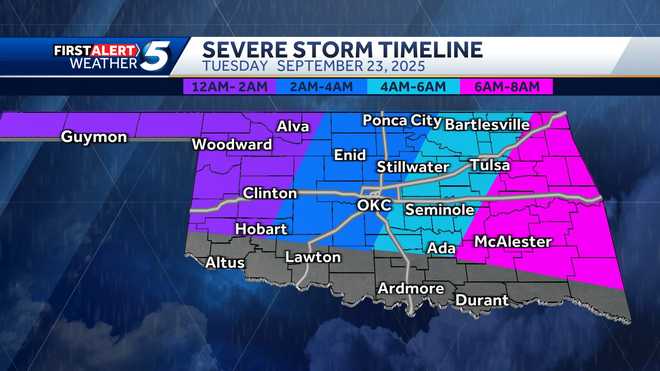
The window for storms:
Panhandle and Western Oklahoma: Midnight to 2 a.m.West-central and Central Oklahoma (including OKC metro): 2-4 a.m.East of I-35: 4-6 a.m. Eastern Oklahoma: 6-8 a.m.
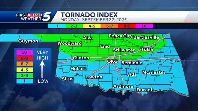
A level 2 slight risk has been issued for northern Oklahoma. The risk zone is north of the OKC metro and includes areas near Stillwater, Tulsa, Enid, Bartlesville, Ponca City, Alva and Woodward.
A level 1 marginal risk has been issued for the rest of the state, including the OKC metro.
The tornado index is 2 out of 10 in northern Oklahoma where ethe slight risk was issued. Michael says it’s a low tornado risk, and it comes down just north of the OKC metro.
The storms also could produce hail the size of golf balls in northwestern Oklahoma. Other parts of the state could get small hail stones.
Another severe weather risk moves into Oklahoma after 10 p.m. on Tuesday. A marginal risk has been issued for south-central, central, northern and northeastern Oklahoma. There’s also a slight risk for southeastern Oklahoma.
Those storms also pose a tornado risk, with the biggest threat being in eastern Oklahoma near the Arkansas border. The tornado index is 4 out of 10 and lessens the further west you go.
7:15 a.m. Monday Update: KOCO 5 Meteorologist Jonathan Conder says a level 2 slight risk has been issued for the OKC metro, western, northern and northwestern Oklahoma. A level 1 marginal risk also has been issued for the rest of the state.
The tornado index is 2 out of 10 for the OKC metro and to the north of Interstate 40 and 1 out of 10 for the rest of Oklahoma. Jonathan says we’re going to be looking for rotating storms.

Jonathan says the storms could produce hail as big as golf balls and wind gusts as strong as 70 mph.
This is a nocturnal event, as storms with a tornado risk will come in during the overnight hours.
This content is imported from Facebook.
You may be able to find the same content in another format, or you may be able to find more information, at their web site.
Radar predictor shows a dry day, with storms coming into far northwestern Oklahoma out of Kansas around 8 p.m. More robust storms will then be near Beaver, Buffalo, Alva and Woodward around 1 a.m. Tuesday.
Those storms will move to the east from 2-4 a.m. Tuesday between Highway 81 and Interstate 35. They’ll then move east of Interstate 35 after 6-8 a.m. Tuesday.

Jonathan says there’s another risk of severe weather, possibly with a more significant tornado risk, hitting eastern Oklahoma on Tuesday.
Be sure to download the KOCO 5 App to receive customized weather alerts. You can watch our team coverage on the app, too.
>> Check Live, Interactive Radar
>> Download the KOCO 5 App on iPhone
>> Download the KOCO 5 App on Android
>> Stream KOCO 5 weather updates anytime on the Very Local app

