CHICAGO — The city’s first snow of the season will be a significant winter storm that could dump eight inches of snow on the city, wrecking Monday morning commutes, according to the National Weather Service.
A winter storm warning has been issued for Chicago starting midnight Sunday through noon Monday. The lake-effect snow system could send six-through-10 inches of snow into the region, with totals likely higher closer to the lakefront, according to the warning.
A “ferocious, thin band of snow” will move into the area Sunday night, which could bring two-to-three inches of snow an hour, National Weather Service meteorologist Gino Izzi said.
Snowfall totals are difficult to predict and could vary depending on a neighborhood or suburb’s proximity to Lake Michigan due to the relatively narrow width of the storm, he explained.
“The ranges you have with lake-effect snow tend to be very fickle with totals,” Izzi said. “There tends to be very substantial gradients, where Humboldt Park could end up with just an inch or two of snow and the Loop gets 12. I’m not saying that’s going to happen, but it is hard to say exactly what those totals are going to be and where they’re going to be … but what we can say is it’s going to hit pretty hard when it hits.”
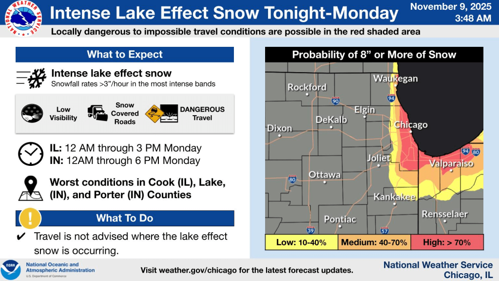
 Chicago could get eight-plus inches of snow overnight Sunday. Credit: National Weather Service Chicago Office
Areas of Chicago closest to the lakefront have a greater than 70 percent chance to see eight-plus inches of snow, according to the weather service.
Much of the snow will fall over night, making for treacherous driving conditions Monday morning, Izzi said. Not only can intense storms clog traffic as snowplows can’t cover large areas in short times, but the storm is the first snowfall of the year, and reacclimation to snowy weather – especially blizzard conditions – can be difficult.
“Just make sure you’re prepared if you go outside,” he said. “And worst case scenario, if you get stuck [on the road], be prepared to be stuck in your car for hours, potentially.”
The winter storm, which could include some lightning and thunder, will include lake-effect snow, which is when a storm system moves over warmer air above a body of water and absorbs that moisture before releasing it as snow.
November tends to be around the time when Chicago gets its first snowfall of the year, but what makes Sunday night’s system unusual is its intensity, Izzi said.
One of the last times the city saw conditions of up to 3 inches of snow per hour was in February 2021, he said.
The snow is expected to end Monday afternoon, when temperatures could rise above freezing, according to the weather service’s forecast. Temperatures will gradually rise through the week, with en expected high of 55 degrees Thursday.
Listen to the Block Club Chicago podcast:

