We hinted earlier in the week that the weekend forecast had big question marks. That’s cleared up a bit, but not entirely. One thing is locked in. California is the national hot spot for rain this weekend, and the bull’s-eye is squarely on Southern California.
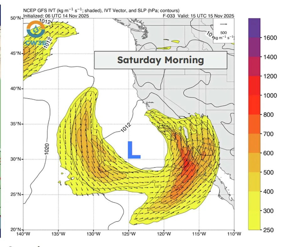
Saturday’s uncertainty comes down to what the atmosphere decides to do south of us. A cutoff low will spin off the Los Angeles coast Saturday morning and tug the core of the atmospheric river into a more south-to-north orientation.
That setup will spike precipitable water – the total amount of moisture in the atmosphere – to near-record levels over Los Angeles and San Diego. That deep moisture then runs up the Central Valley toward the Sierra and the Bay Area.
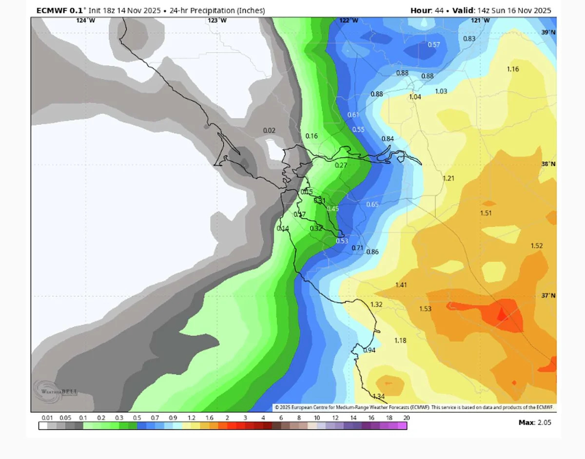
That puts us back in the line of fire for rain Saturday, but with nuance. Right now, the high-moisture boundary looks like it will stall just south of the Bay Area – close enough for rain to reach the South Bay and parts of the East Bay, but not far enough north for a full-region soak. But this is a tight gradient. A 20-mile shift north pulls San Francisco and the North Bay into steadier rainfall; a 20-mile shift south leaves most of us with mist and cloud cover.
For now, the most likely scenario is a mostly cloudy, cool Saturday with highs in the 60s. A shield of precipitation lifts from the south Saturday afternoon, with the best chances for showers from late afternoon through Sunday morning, especially in the South Bay, Santa Cruz Mountains and the East Bay interior. Totals look manageable: roughly 0.1 to 0.5 inches.
More to come
Sunday brings a brief dry window, about 12 hours of it, but skies stay cloudy and cool with occasional breaks of sun.
By late Sunday night, the next Pacific system arrives. This one is progressive, not meandering, and behaves more like a classic fall cold front. We should see a 6- to 10-hour period of light rain with gusty winds and rainfall totals under an inch for most. The bulk of the precipitation should fall from Sunday evening through Monday morning.
And we’re not done. Monday and Tuesday look fine with clouds, some sun breaks and temperatures in the 60s. But another system is lined up for midweek, bringing another round of rain.
Southern California soaker
The core of the atmospheric river will be pointed right at Los Angeles and San Diego on Saturday. Several rounds of moderate to heavy rain will rotate through the region on Saturday, generally dropping 2 to 4 inches of rain, with higher totals in the hills and mountains around both cities.

A cutoff low pressure system (blue L) will hover off the Southern California coast and align the core of the atmospheric river (orange and red) pointed south to north. That will drive another batch of rain northward towards the Bay Area on Saturday. (NOAA)
Flood watches are in place for the entire region on Saturday. Rainfall rates will exceed 0.5 inches per hour at times, causing flash floods, landslides and debris flows in wildfire burn scars. NOAA has also put Los Angeles under a moderate risk for excessive rainfall on Saturday. On past moderate-risk days in L.A., more than 80% of the region’s flood damage and over 30% of flood-related deaths have occurred.
Heavy rain in the desert and Sierra snow
Even the high deserts of interior Southern California will get soaked from this storm. The plume of high moisture will spread across the Antelope Valley and Mojave Desert on Saturday afternoon. One to 3 inches of rain will fall in Lancaster, Barstow and Ridgecrest. That’s enough to cause minor flooding. Even Death Valley should see over an inch of rain over the weekend.
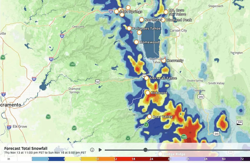
The Sierra Nevada will get a renewed shot at snowfall as well from the surge of moisture. After the last storm ended up much warmer than forecast, none of the Sierra ski resorts ended up with significant snow this week, prompting Mammoth Mountain to delay its season opening until the end of November.

The latest snowfall forecast for Tahoe resorts looks more promising than the last storm. By Sunday, a few inches of snow should be on the ground at most mountains. (OpenSnow )
This weekend’s system should have a bit more cold air to work with and snow levels will be around 6,000 feet at their lowest. The big wild card will be how far north the moisture surge makes it. The Tahoe region looks right on the edge of the moisture shield for now, but a few inches of snow are a good bet this weekend at the Tahoe resorts, with more chances on the horizon given the active storm pattern.
This article originally published at Atmospheric river targets Southern California while Bay Area rides the storm’s edge.

