QUICK LINKS|| Closings/Delays | Weather Advisories | Radar | Forecast | Email Alerts | Send us your pics |||| @wbaltv11 | @TTasselWBAL | @AvaWBAL | @TonyPannWBAL | @DalenciaWBAL | @AlenaLeeWX ||RESOURCES: WBAL-TV 11 Winter Weather Guide | Get Weather Push AlertsTRACK SNOW PLOWS: State | Anne Arundel | City | Baltimore Co. | Carroll | Harford | HowardCDC: Preventing Frostbite, HypothermiaREADY.gov: Disaster Kit | Car SafetyWEATHER TALK: Prepare Pets for Winter BALTIMORE — A winter storm is on track to bring heavy snow to Maryland from Saturday night to Sunday night.The National Weather Service upgraded its advisory to a Winter Storm Warning for snow this weekend in Baltimore. It takes effect Saturday night and lasts through Monday.States of Emergency issuedMaryland Gov. Wes Moore on Friday afternoon issued a State of Emergency to clear the way for immediate use of state resources across agencies, including the Maryland National Guard.”This winter storm has the potential to be remarkably dangerous,” Moore said Friday afternoon. “A storm of this magnitude demands an all government response that protects all of our people before, during and after the snowfall.”The State Emergency Operations Center and the Maryland State Highway Administration Emergency Operations Center will activate Saturday. Maryland State Police will increase staffing across the state.”We are asking Marylanders to be a part of this preparedness effort starting right now. We are asking to first and foremost stay off the roads throughout the storm,” Maryland Emergency Management Secretary Russell Strickland said.”Our ask, our plea to the people in the state is, if you can, stay off the roads. If you can, please hunker down. Do not think that this is an understatement or a game. It is not,” Moore said. “For people who are essential, for people who have to go out, I would say, please follow the instructions we have laid out.”Video below: Gov. Wes Moore, state leaders update storm preparednessThe Maryland Department of Transportation has readied thousands of pieces of equipment as crews pretreat roads with salt brine. Crews will work 12-hour shifts to clear the snow.”We will also be monitoring pavement conditions in real time with infrared technology in fixed weather stations and on more than 100 vehicles across the state. This technology helps us determine if the road is about to freeze. If that happens, we will dispatch crews and warn travelers with overhead messaging signs,” Maryland acting Transportation Secretary Katie Thomson said.The Maryland National Guard has mobilized more than 100 personnel to provide transportation, mobility and logistical support to preserve public safety, save lives, prevent human suffering, mitigate property damage, and enable recovery efforts.”We’ll be out in Hagerstown, Sykesville, Havre de Grace, Easton, Salisbury and Dundalk initially, with a small contingent in Baltimore at the Fifth Regiment Armory,” Maryland National Guard adjutant general Maj. Gen. Janeen Birckhead said.Video below: How the state is preparing for the stormThe Maryland Public Service Commission is coordinating utilities on storm preparedness efforts and outage response, particularly with the potential for heavy snow and ice accumulation.”We could have parts of the state where the snow is the least of the issues that we’re concerned about. It will actually be the ice that we’re concerned about,” Moore said.The governor said he has also requested a federal emergency declaration for personnel, equipment and funding for protective measures.Baltimore Mayor Brandon Scott also issued a State of Emergency for the city, and Phase 2 of Baltimore’s Snow Emergency Plan will take effect at noon Saturday.”Road pretreatment has already started, and we’ve lined up the tools that we need to manage the snow, including additional plow and salt contractors. We’re in close contact with our partners at the state and the federal level, including to coordinate assets like Humvees and high-clearance vehicles from the Maryland National Guard,” Scott said Friday.The Carroll County Board of County Commissioners also issued a State of Emergency.Here’s what we’re trackingHere’s what we’re watching on all the different computer models coming in to WBAL-TV.Download the WBAL-TV app NOW and turn on push alerts to receive winter weather advisories and warnings, listen to NOAA Weather radio, and watch WBAL-TV 11 News as impending snowstorms develop.The snow will begin on Saturday night and become heaviest on Sunday morning. Road conditions could deteriorate quickly on Sunday morning, with potential snowfall rates of up to 1 1/2 inches per hour.| WINTER GUIDE: Snow safety, driving hazards | Preparing your home for snowThe storm will change over to ice that could either come down as sleet (pellets of ice) or freezing rain (super-cold rain that freezes into ice when it hits cold surfaces). Either scenario could make for dangerous travel and increase the risk of downed trees and power outages, as it weighs down the already snow-covered trees and power lines.| SNOW TIMELINE: Futurecast shows snow transitioning to ice in BaltimoreDon’t expect the snow and ice to disappear anytime soon. Temperatures may remain below freezing all of next week. Now is a good time to protect any property that is sensitive to prolonged cold weather, including outdoor plumbing. Snow totals forecast updateMeteorologist Ava Marie on updated the snow totals forecast …In total, the Baltimore area is likely to get 8-12 inches of snow before the mixture begins to change over to ice.To the south, where the change to ice happens sooner, some areas could get as little as 6 inches of snow.Where the snow lasts longer, like in the northwest suburbs of Baltimore, those areas could receive more than a foot of snow.Video below: Futurecast timeline shows snow turning to iceBaltimore snow timeline Snow begins after 11 p.m. Saturday Heavy snow Sunday morning, changing to ice in the afternoon Ending by Sunday 11 p.m. 8-12 inches for most of Baltimore area, less south and more northwest Still some wiggle room on total amounts given the trickiness of the changeover to iceDon’t expect the snow and ice to disappear anytime soon. Temperatures may remain below freezing all of next week. Now is a good time to protect any property that is sensitive to prolonged cold weather, including outdoor plumbing.This article will be updated. The WBAL-TV 11 Weather team will keep you updated as soon as there is more confidence in the snow forecast models.Why a human touch mattersCellphone weather forecast apps are based on only one model solution while there are dozens of models.While you might see elsewhere some snow predictions that include accumulation forecasts, refresh WBALTV.com often for an updated interpretation from our team of meteorologists who know Baltimore weather, and its patterns, best.Video below: Baltimore City officials update storm preparednessVideo below: Baltimore County officials update storm preparedness Are you prepared?Video below: Crews prepare for winter snowstorm, offer tips With just days until the winter storm is expected to reach the Baltimore region, state and local officials are urging residents to be prepared for the winter blast, and experts are weighing in on how to stay safe.Grocery stores, like the Safeway in Canton, are stocking up on the essentials ahead of what they expect will be a big rush leading up to the storm.Meanwhile, experts shared several tips with WBAL-TV 11 News about how to make sure your car is winterized, should you need to drive somewhere during the storm. Officials, however, ask residents to stay home unless they need to leave. It’s been a while since Baltimore got a lot of snowA decade has passed since Baltimore received snowfall of more than 6 inches — could that change this weekend?Thursday marks the 10-year anniversary of Baltimore’s biggest snow event on record: The Blizzard of January 2016!Weather Talk video below: Remembering the Blizzard of 2016 in MarylandMeteorologist Tony Pann takes a look back at the data from the weather station at Baltimore-Washington International Thurgood Marshall Airport recorded 29.2 inches of snow, and other spots north of Baltimore reached over 30 inches.It has been 10 years since Baltimore received any storm produce more than 6 inches of snow at BWI-Marshall.WBAL-TV 11 Maryland Weather RadarApp users tap here for interactive radar.Alert Days vs. Impact DaysYou may see the WBAL-TV 11 Weather Team highlight Alert Days or Impact Days in the forecasts. Here’s what that means:An Impact Day is when weather will likely disrupt your normal daily schedule or routine.An Alert Day is when there’s a threat of extreme, severe and possibly life-threatening weather. Share your weather photos and videosWhen and where safe, show us your weather photos and videos, we may show them on 11 News or online!DIRECT UPLOAD: Use this form to upload photos or video.EMAIL: Just email your photos and video to news@wbaltv.com.PGlmcmFtZSB0aXRsZT0iRmxpZ2h0IGNhbmNlbGxhdGlvbnMsIGRlbGF5cyBieSBvcmlnaW4gYWlycG9ydCBvbiBOb3YuIDExIiBhcmlhLWxhYmVsPSJUYWJsZSIgaWQ9ImRhdGF3cmFwcGVyLWNoYXJ0LWY5RkRjIiBzcmM9Imh0dHBzOi8vZGF0YXdyYXBwZXIuZHdjZG4ubmV0L2Y5RkRjLzkyLyIgc2Nyb2xsaW5nPSJubyIgZnJhbWVib3JkZXI9IjAiIHN0eWxlPSJ3aWR0aDogMDsgbWluLXdpZHRoOiAxMDAlICFpbXBvcnRhbnQ7IGJvcmRlcjogbm9uZTsiIGhlaWdodD0iODEzIiBkYXRhLWV4dGVybmFsPSIxIj48L2lmcmFtZT48c2NyaXB0IHR5cGU9InRleHQvamF2YXNjcmlwdCI+d2luZG93LmFkZEV2ZW50TGlzdGVuZXIoIm1lc3NhZ2UiLGZ1bmN0aW9uKGEpe2lmKHZvaWQgMCE9PWEuZGF0YVsiZGF0YXdyYXBwZXItaGVpZ2h0Il0pe3ZhciBlPWRvY3VtZW50LnF1ZXJ5U2VsZWN0b3JBbGwoImlmcmFtZSIpO2Zvcih2YXIgdCBpbiBhLmRhdGFbImRhdGF3cmFwcGVyLWhlaWdodCJdKWZvcih2YXIgcixpPTA7cj1lW2ldO2krKylpZihyLmNvbnRlbnRXaW5kb3c9PT1hLnNvdXJjZSl7dmFyIGQ9YS5kYXRhWyJkYXRhd3JhcHBlci1oZWlnaHQiXVt0XSsicHgiO3Iuc3R5bGUuaGVpZ2h0PWR9fX0pOzwvc2NyaXB0Pg==PHNjcmlwdCB0eXBlPSJ0ZXh0L2phdmFzY3JpcHQiPiFmdW5jdGlvbigpeyJ1c2Ugc3RyaWN0Ijt3aW5kb3cuYWRkRXZlbnRMaXN0ZW5lcigibWVzc2FnZSIsKGZ1bmN0aW9uKGUpe2lmKHZvaWQgMCE9PWUuZGF0YVsiZGF0YXdyYXBwZXItaGVpZ2h0Il0pe3ZhciB0PWRvY3VtZW50LnF1ZXJ5U2VsZWN0b3JBbGwoImlmcmFtZSIpO2Zvcih2YXIgYSBpbiBlLmRhdGFbImRhdGF3cmFwcGVyLWhlaWdodCJdKWZvcih2YXIgcj0wO3I8dC5sZW5ndGg7cisrKXtpZih0W3JdLmNvbnRlbnRXaW5kb3c9PT1lLnNvdXJjZSl0W3JdLnN0eWxlLmhlaWdodD1lLmRhdGFbImRhdGF3cmFwcGVyLWhlaWdodCJdW2FdKyJweCJ9fX0pKX0oKTs8L3NjcmlwdD4=
QUICK LINKS
|| Closings/Delays | Weather Advisories | Radar | Forecast | Email Alerts | Send us your pics ||
|| @wbaltv11 | @TTasselWBAL | @AvaWBAL | @TonyPannWBAL | @DalenciaWBAL | @AlenaLeeWX ||
BALTIMORE — A winter storm is on track to bring heavy snow to Maryland from Saturday night to Sunday night.
The National Weather Service upgraded its advisory to a Winter Storm Warning for snow this weekend in Baltimore. It takes effect Saturday night and lasts through Monday.
States of Emergency issued
Maryland Gov. Wes Moore on Friday afternoon issued a State of Emergency to clear the way for immediate use of state resources across agencies, including the Maryland National Guard.
“This winter storm has the potential to be remarkably dangerous,” Moore said Friday afternoon. “A storm of this magnitude demands an all government response that protects all of our people before, during and after the snowfall.”
“This winter storm has the potential to be remarkably dangerous.”
The State Emergency Operations Center and the Maryland State Highway Administration Emergency Operations Center will activate Saturday. Maryland State Police will increase staffing across the state.
“We are asking Marylanders to be a part of this preparedness effort starting right now. We are asking to first and foremost stay off the roads throughout the storm,” Maryland Emergency Management Secretary Russell Strickland said.
“Our ask, our plea to the people in the state is, if you can, stay off the roads. If you can, please hunker down. Do not think that this is an understatement or a game. It is not,” Moore said. “For people who are essential, for people who have to go out, I would say, please follow the instructions we have laid out.”
Video below: Gov. Wes Moore, state leaders update storm preparedness
The Maryland Department of Transportation has readied thousands of pieces of equipment as crews pretreat roads with salt brine. Crews will work 12-hour shifts to clear the snow.
“We will also be monitoring pavement conditions in real time with infrared technology in fixed weather stations and on more than 100 vehicles across the state. This technology helps us determine if the road is about to freeze. If that happens, we will dispatch crews and warn travelers with overhead messaging signs,” Maryland acting Transportation Secretary Katie Thomson said.
The Maryland National Guard has mobilized more than 100 personnel to provide transportation, mobility and logistical support to preserve public safety, save lives, prevent human suffering, mitigate property damage, and enable recovery efforts.
“We’ll be out in Hagerstown, Sykesville, Havre de Grace, Easton, Salisbury and Dundalk initially, with a small contingent in Baltimore at the Fifth Regiment Armory,” Maryland National Guard adjutant general Maj. Gen. Janeen Birckhead said.
Video below: How the state is preparing for the storm
The Maryland Public Service Commission is coordinating utilities on storm preparedness efforts and outage response, particularly with the potential for heavy snow and ice accumulation.
“We could have parts of the state where the snow is the least of the issues that we’re concerned about. It will actually be the ice that we’re concerned about,” Moore said.
The governor said he has also requested a federal emergency declaration for personnel, equipment and funding for protective measures.
Baltimore Mayor Brandon Scott also issued a State of Emergency for the city, and Phase 2 of Baltimore’s Snow Emergency Plan will take effect at noon Saturday.
“Road pretreatment has already started, and we’ve lined up the tools that we need to manage the snow, including additional plow and salt contractors. We’re in close contact with our partners at the state and the federal level, including to coordinate assets like Humvees and high-clearance vehicles from the Maryland National Guard,” Scott said Friday.
The Carroll County Board of County Commissioners also issued a State of Emergency.
Here’s what we’re tracking
Here’s what we’re watching on all the different computer models coming in to WBAL-TV.
Download the WBAL-TV app NOW and turn on push alerts to receive winter weather advisories and warnings, listen to NOAA Weather radio, and watch WBAL-TV 11 News as impending snowstorms develop.
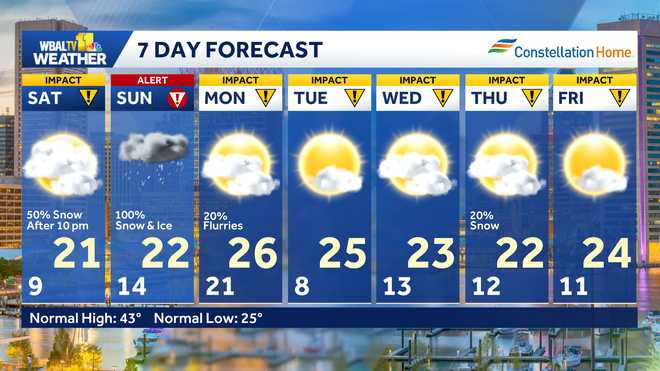
The snow will begin on Saturday night and become heaviest on Sunday morning. Road conditions could deteriorate quickly on Sunday morning, with potential snowfall rates of up to 1 1/2 inches per hour.
| WINTER GUIDE: Snow safety, driving hazards | Preparing your home for snow
The storm will change over to ice that could either come down as sleet (pellets of ice) or freezing rain (super-cold rain that freezes into ice when it hits cold surfaces). Either scenario could make for dangerous travel and increase the risk of downed trees and power outages, as it weighs down the already snow-covered trees and power lines.
| SNOW TIMELINE: Futurecast shows snow transitioning to ice in Baltimore
This content is imported from Twitter.
You may be able to find the same content in another format, or you may be able to find more information, at their web site.
Sleet & Freezing Rain. What’s the difference? Sleet comes down frozen. Little pellets of ice. Freezing Rain comes down in liquid form, then freezes into a glaze of ice when it hits the surface. See the graphic below about how the thermal profile sets up for each type. 👇 The… pic.twitter.com/IaEUJUEO6c
— Tony Pann (@TonyPannWBAL) January 23, 2026
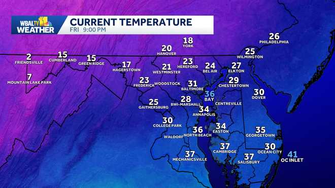
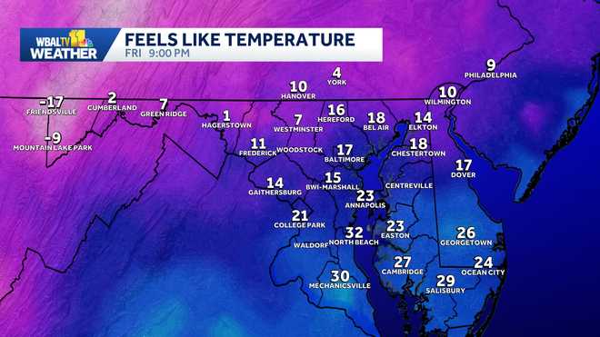
Don’t expect the snow and ice to disappear anytime soon. Temperatures may remain below freezing all of next week. Now is a good time to protect any property that is sensitive to prolonged cold weather, including outdoor plumbing.
Snow totals forecast update
Meteorologist Ava Marie on updated the snow totals forecast …
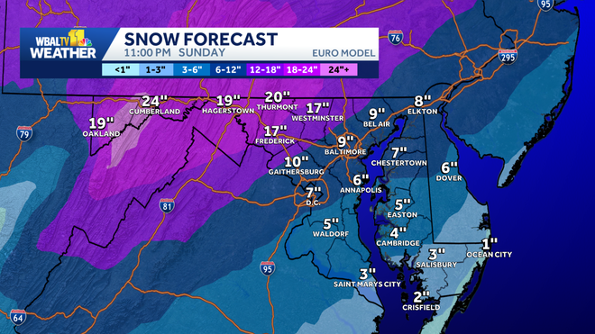
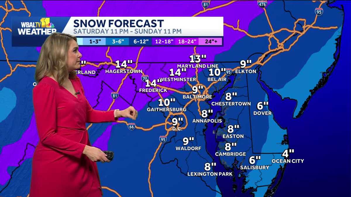
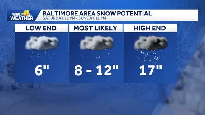
In total, the Baltimore area is likely to get 8-12 inches of snow before the mixture begins to change over to ice.
To the south, where the change to ice happens sooner, some areas could get as little as 6 inches of snow.
Where the snow lasts longer, like in the northwest suburbs of Baltimore, those areas could receive more than a foot of snow.
Video below: Futurecast timeline shows snow turning to ice
Baltimore snow timeline Snow begins after 11 p.m. Saturday Heavy snow Sunday morning, changing to ice in the afternoon Ending by Sunday 11 p.m. 8-12 inches for most of Baltimore area, less south and more northwest Still some wiggle room on total amounts given the trickiness of the changeover to ice
Don’t expect the snow and ice to disappear anytime soon. Temperatures may remain below freezing all of next week. Now is a good time to protect any property that is sensitive to prolonged cold weather, including outdoor plumbing.
This article will be updated. The WBAL-TV 11 Weather team will keep you updated as soon as there is more confidence in the snow forecast models.
Why a human touch matters
Cellphone weather forecast apps are based on only one model solution while there are dozens of models.
While you might see elsewhere some snow predictions that include accumulation forecasts, refresh WBALTV.com often for an updated interpretation from our team of meteorologists who know Baltimore weather, and its patterns, best.
This content is imported from Twitter.
You may be able to find the same content in another format, or you may be able to find more information, at their web site.
If the weather app on your phone is cranking out wild snow numbers like mine, ignore it. It’s most likely 6-10″ for the Baltimore Metro, 10-15″ possible in the coldest parts of N. Baltimore, Carroll, Frederick Counties, followed by a 0.10″ to 0.20″ glaze of ice on top. Details… pic.twitter.com/gd935gnCuU
— Tom Tasselmyer (@ttasselWBAL) January 23, 2026
This content is imported from Twitter.
You may be able to find the same content in another format, or you may be able to find more information, at their web site.
“Hey Tony, my phone says there will be 15″ of snow!” Heard a version of that a lot today. 😁 Phone weather forecast apps are based on only one model solution. There are dozens of models! It’s a pro forecaster’s job to sift through all of that information, and present the most… pic.twitter.com/aqn4m4GEVr
— Tony Pann (@TonyPannWBAL) January 20, 2026
Video below: Baltimore City officials update storm preparedness
Video below: Baltimore County officials update storm preparedness
This content is imported from YouTube.
You may be able to find the same content in another format, or you may be able to find more information, at their web site.
Are you prepared?
Video below: Crews prepare for winter snowstorm, offer tips
With just days until the winter storm is expected to reach the Baltimore region, state and local officials are urging residents to be prepared for the winter blast, and experts are weighing in on how to stay safe.
Grocery stores, like the Safeway in Canton, are stocking up on the essentials ahead of what they expect will be a big rush leading up to the storm.
Meanwhile, experts shared several tips with WBAL-TV 11 News about how to make sure your car is winterized, should you need to drive somewhere during the storm. Officials, however, ask residents to stay home unless they need to leave.
It’s been a while since Baltimore got a lot of snow
A decade has passed since Baltimore received snowfall of more than 6 inches — could that change this weekend?
Thursday marks the 10-year anniversary of Baltimore’s biggest snow event on record: The Blizzard of January 2016!
Weather Talk video below: Remembering the Blizzard of 2016 in Maryland
Meteorologist Tony Pann takes a look back at the data from the weather station at Baltimore-Washington International Thurgood Marshall Airport recorded 29.2 inches of snow, and other spots north of Baltimore reached over 30 inches.
It has been 10 years since Baltimore received any storm produce more than 6 inches of snow at BWI-Marshall.
This content is imported from Twitter.
You may be able to find the same content in another format, or you may be able to find more information, at their web site.
Today is the 10 year anniversary of the Blizzard of January 2016! Baltimore’s biggest snow event on record: 29.2″ at BWI! Tom Tasselmyer and I flipped a coin to see who would go out on the WBAL TV Weather Veranda to take a snow measurement. I won! 👇 I took this picture of him… pic.twitter.com/RUQyf3Wt6g
— Tony Pann (@TonyPannWBAL) January 22, 2026
WBAL-TV 11 Maryland Weather Radar
App users tap here for interactive radar.
Alert Days vs. Impact Days
You may see the WBAL-TV 11 Weather Team highlight Alert Days or Impact Days in the forecasts. Here’s what that means:
An Impact Day is when weather will likely disrupt your normal daily schedule or routine.An Alert Day is when there’s a threat of extreme, severe and possibly life-threatening weather. Share your weather photos and videos
When and where safe, show us your weather photos and videos, we may show them on 11 News or online!

