
Download the First Warn Weather app here
COPYRIGHT 2025 BY CHANNEL 3000. ALL RIGHTS RESERVED. THIS MATERIAL MAY NOT BE PUBLISHED, BROADCAST, REWRITTEN OR REDISTRIBUTED.
WHAT WE’RE TRACKING:

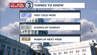
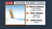
Subzero Wind Chills Grip The RegionFrigid Air Stays Through FridayNext Chance of Snow Sunday
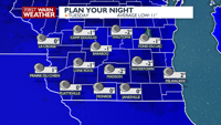
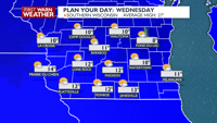
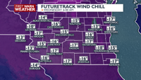
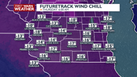
PLANNING THE NEXT 24 HOURS: Tonight will be frigid as temperatures drop below zero, with wind chills plummeting into the negative teens with clear skies. It will stay very cold Wednesday with highs struggling to get about ten with partly sunny skies. Expect clear skies and bitterly cold temperatures below zero Wednesday night. Wind chills will fall back into the negative teens.
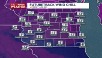
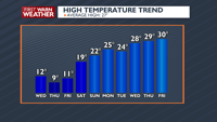
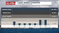
EXTENDED FORECAST: The deep freeze continues through Friday as high pressure keeps southern Wisconsin mostly dry but very cold. High temperatures will remain in the teens with sub-zero lows until a slight warming trend arrives on Saturday. We are monitoring the potential for snow showers by Sunday evening. Next week temperatures will return to normal readings, with highs getting back into the 20s to near 30.
COPYRIGHT 2026 BY CHANNEL 3000. ALL RIGHTS RESERVED.THIS MATERIAL MAY NOT BE PUBLISHED, BROADCAST, REWRITTEN OR REDISTRIBUTED
Humidity: 54%
Feels Like: -8°
Heat Index: 4°
Wind: 8 mph
Wind Chill: -8°
UV Index: 0 Low
Sunrise: 07:18:17 AM
Sunset: 05:04:07 PM
Dew Point: -9°
Visibility: 10 mi
Today
Mostly clear and bitterly cold. Wind chills near -15. Wind: W 6-12 MPH.
Tonight
Mostly clear and bitterly cold. Wind chills near -15. Wind: W 6-12 MPH.
Tomorrow
Partly sunny and very cold. Morning wind chills near -15.
Wind: W 6-12 MPH
Tue
Tuesday
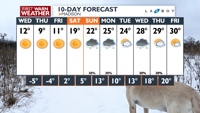
12°/-2°
Mostly clear. Lows overnight -4 to 0F.
Tuesday Night
Mostly clear and bitterly cold. Wind chills near -15. Wind: W 6-12 MPH.
Wed
Wednesday
12°/-5°
Partly cloudy. Highs in the mid teens and lows -7 to -3F.
Wednesday Night
Mostly clear and bitterly cold. Wind chills near -15 to -20. NW 5-10 MPH.
Thu
Thursday
9°/-4°
More sun than clouds. Highs in the mid teens and lows -2 to 2F.
Thursday Night
Mostly clear and bitter cold. Morning wind chills near -15 to -20.
Fri
Friday
11°/2°
Partly cloudy. Highs in the mid teens and lows in the mid single digits.
Friday Night
Mostly clear and very cold. Wind chills near -10.
Sat
Saturday
19°/5°
A few clouds. Highs in the low 20s and lows in the mid single digits.
Saturday Night
Mostly cloudy and very cold.
Sun
Sunday
22°/13°
Mix of sun and clouds. Highs in the mid 20s and lows in the mid teens.
Sunday Night
Mostly cloudy with a chance of snow showers overnight.
Mon
Monday
25°/10°
Cloudy. Highs in the upper 20s and lows in the low teens.
Monday Night
Mostly cloudy and seasonable.
Tue
Tuesday
24°/13°
Considerable cloudiness. Highs in the mid 20s and lows in the low 20s.
Tuesday Night
Mostly cloudy with a slight chance of snow showers at night.
Wed
Wednesday
28°/18°
Snow showers in the morning. Highs in the upper 20s and lows in the upper teens.
Wednesday Night
Mostly cloudy with a chance for snow showers at night.
Thu
Thursday
29°/20°
Mostly cloudy. Highs in the upper 20s and lows in the low 20s.
Thursday Night
Partly cloudy and a little warmer.