
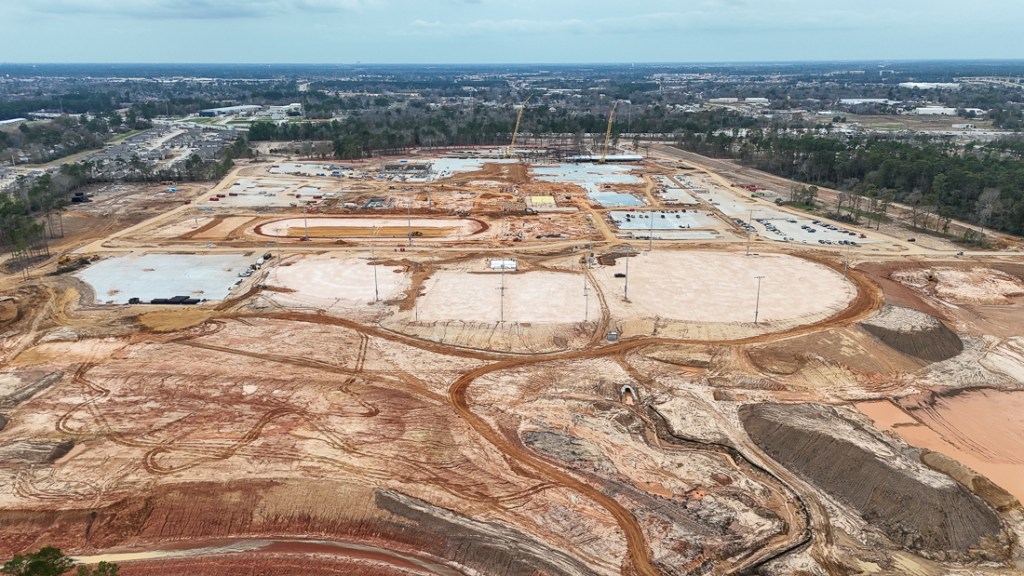
2/11/26 – Based on a tip from a reader, I learned that a large construction site along Spring Creek near the Hardy Toll Road and State Highway 99 was pumping muddy stormwater directly into Spring Creek.
Images Sent By Reader
The reader sent me pictures taken along the Spring Creek Greenway that suggested this was no accidental overflow. The images show neatly cut and stacked underbrush along a ditch cut between the construction site and the creek.
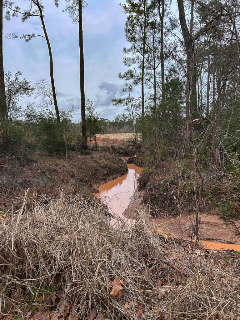 Photo taken by reader on 2/10/26. Reader wishes to remain anonymous.
Another photo taken from a greenway bridge shows the speed of the discharge.
 Note that the discharge appears to have been much higher at one point judging by the grass laying down.
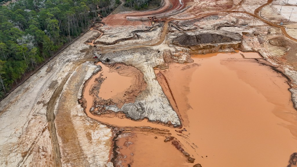
Aerial Images Taken on 2/10/2026
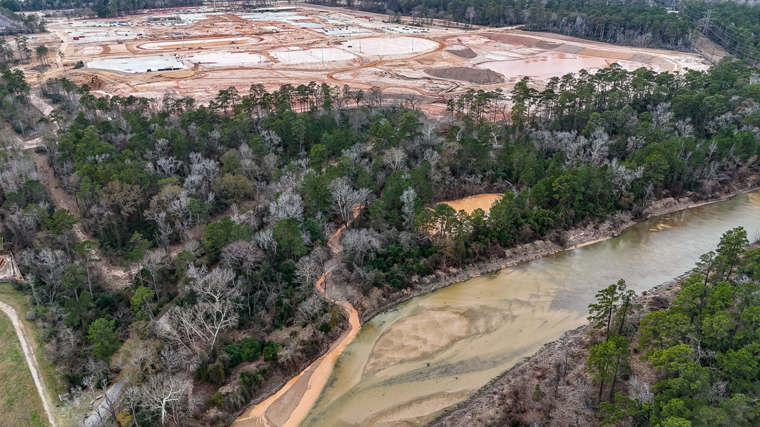
So, I grabbed my drone and headed over to nearby Harris County Precinct 3 Dennis Johnston Park. From the air, you could clearly see where the sediment-laden sludge was coming from.
 Construction site emptying detention basin straight into Spring Creek
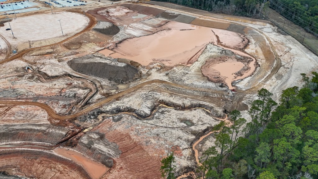 Someone had cut channels to drain silty stormwater from a drainage ditch and detention basin.
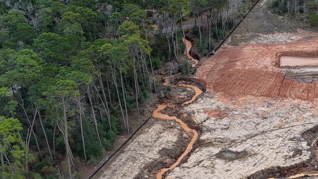
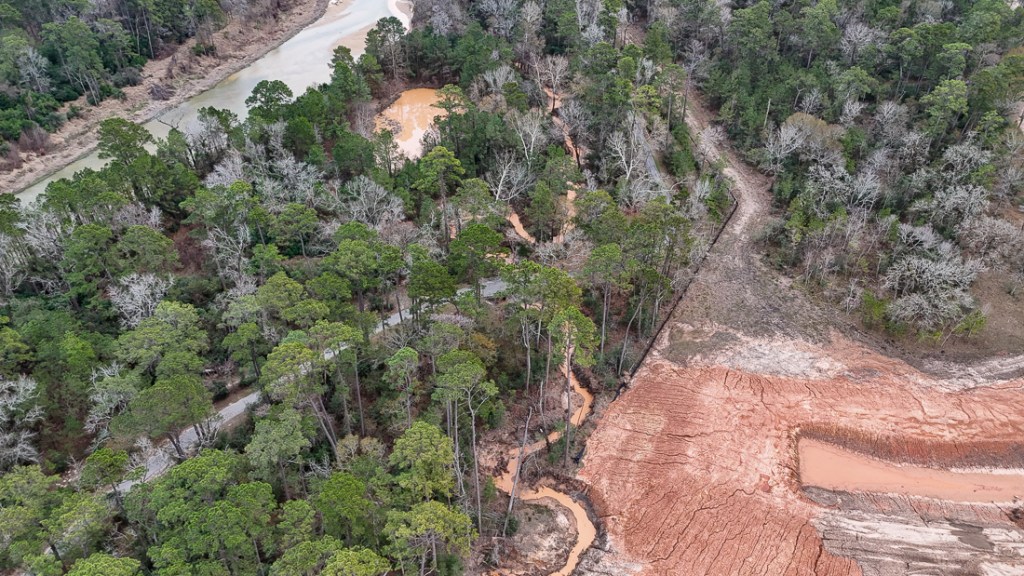 The path to Spring Creek took the sludge under the greenway in the forest.
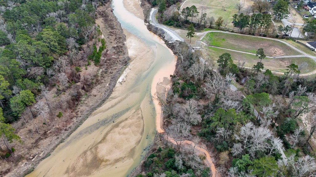
 Opposite angle shows muck flowing straight into Spring Creek.
 Silt migrating downstream toward Harmony, Benders Landing Estates, Humble, Kingwood and Lake Houston.
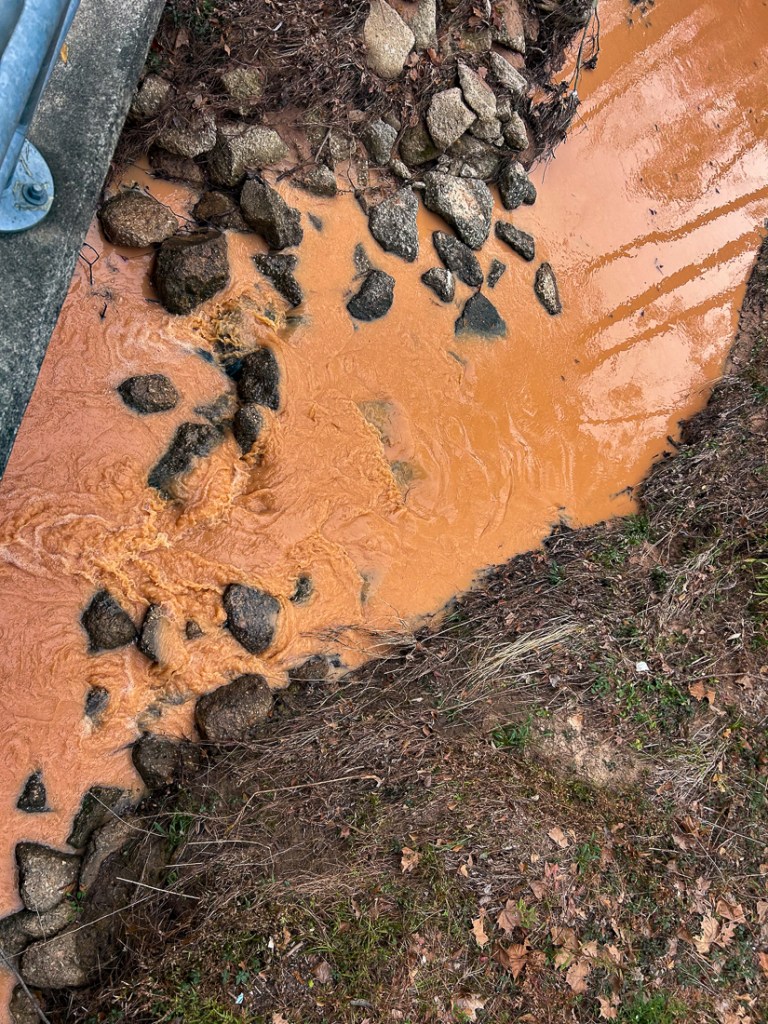
 They were actually pumping the sediment from the stormwater detention basin.
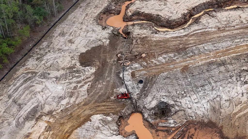
 What they were pumping
 …And those silt fences don’t do much good when you tear them down.
The Human Toll: Ruining a Community Asset
The reader who sent me the ground level images told me how she felt she had had a pleasant experience stolen from her. She was out for a fun bike ride during spring break. The Spring Creek Greenway is one of the longest urban trails in North America. It is supposed to be a refuge. But instead of clear water and a healthy ecosystem, she found this appalling sight.
She said the plume was migrating downstream toward Jesse Jones Park where she saw “tons of kids fishing today.”
An avid environmentalist, she says, “Siltation kills the fishing experience. The cloudy water makes it impossible for sight-feeding fish to hunt for insects. And the heavy sediment smothers the ‘honey holes’ where fish congregate.”
Silt Contributes to Flooding
When a developer pumps mud into the creek, that sediment eventually settles and raises the creek bed. That means the channel holds less water.
Spring Creek is a major tributary to the San Jacinto West Fork. Every ton of mud pumped into the Spring Creek eventually migrates downstream to the San Jacinto, exacerbating flood risks in Humble, Kingwood and the Lake Houston Area.
Pumping silt like this also creates a burden on taxpayers. Developers profit by taking “shortcuts” on-site. But the public pays the price. When the river fills with silt and flood risk increases, taxpayers bear the burden of multi-million dollar dredging projects to restore the river’s capacity.
Since Harvey, taxpayers have spent hundreds of millions of dollars dredging area rivers.
Ecological Suffocation
My source, who wishes to remain anonymous, talked about “gill clogging.” High concentrations of suspended solids can literally suffocate fish.
Silt settling into the gravel and woody debris on the creek floor also smothers the macro-invertebrates (bugs) that form the base of the food chain.
Just as bad, such activities kill the filtering mechanism that keeps creeks healthy. Oranizations, such as the Bayou Land Conservancy, work to protect the wetlands that filter our water. Dumping raw silt bypasses this natural filtration and destroys the very plants that help stabilize the banks.
Silt isn’t just dirt. Construction runoff often carries other pollutants attached to the soil particles, including fertilizers, heavy metals, or chemical residues from the site, which are now being “injected” into the local water supply.
That’s why pumping sediment-laden water directly into a creek is a flagrant violation of sediment-control protocols. Not preserving floodplains has many costs that most people don’t realize.
How to Report Such Violations
Readers who share my concerns should report such violations to the Texas Commission on Environmental Quality and the Harris County Flood Control District. You may also want to notify Harris County Precinct 3 and Montgomery County MUDs, as Spring Creek serves as the border between the two counties. Both have a vested interest in keeping that channel clear. Readers report that this is the site of the new Spring ISD High School.
I couldn’t find an entrance to the site with an address, sign, or stormwater pollution prevention plan. But for reporting purposes, the GPS coordinates are: 30°05’16.3″N 95°24’07.6″W.
Posted by Bob Rehak on 2/11/26
3088 Days since Hurricane Harvey
The thoughts expressed in this post represent opinions on matters of public concern and safety. They are protected by the First Amendment of the US Constitution and the Anti-SLAPP Statute of the Great State of Texas.