
DEDHAM, Mass. — Blizzard and winter storm warnings have been issued in Massachusetts ahead of a nor’easter that’s expected to bring heavy snow, strong winds, and coastal flooding concerns on Monday.
The nor’easter is expected to move in on Sunday night before tapering off Monday night into Tuesday.
“This is going to be a big impact storm,” said Boston 25 Meteorologist Vicki Graf. “We’re not just talking about the heavy wet snow; we’re also talking about some stronger wind and some coastal flooding concerns.”
“This is going to be a nor’easter, a classic one,” Boston 25 Meteorologist Tucker Antico said of the storm. “So, we have heavy snow, we’re going to have coastal flooding, mainly on the South Shore and Boston area too. I’m most concerned about power outages here because we have this heavy, wet snow and some very strong winds.”
“We’re looking at gusts anywhere from 30 to 60 mph, so with the heavy wet snow we’re looking at some power outages especially for the coast and southeastern Massachusetts. Something to keep in mind, Monday, the worst of the wind will be early on, eventually easing up late Monday,” said Graf.
Power outages are a top concern in our Monday blizzard. Heavy, wet snow and 50-70 mph gusts will lead to widespread issues. A lack of recent wind events, doesn’t help.
Make sure to charge devices ahead of time and have what you need to stay warm if the power goes out 🪫
— Tucker Antico (@tuckerweather) February 21, 2026
“The worst of it will be with us overnight throughout the day on Monday,” said Graf. “This is an all-day event. We’re looking at heavy wet snow initially, and then eventually a little bit of a lighter snow later in the day on Monday.”
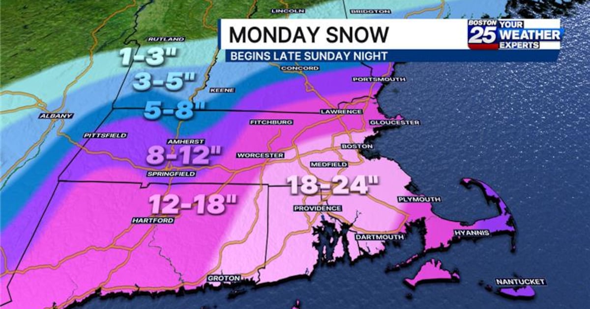
South of Boston into Rhode Island, including parts of the South Coast, South Shore, and Norfolk County are expected to see 18-24 inches.

From most of Connecticut to Worcester County, up to the New Hampshire border, up to a foot of snow is possible.
“The farther north and west you go, those totals will taper slightly,” Graf said.
Antico added, “Just from the numbers alone, this will be a big storm.”
Monday Blizzard Snowfall –
This will be our most impactful storm in several years. Primary impacts occur late Sunday night through Monday evening.
Powerful wind will cause widespread power outages. Minor-mod. coastal flooding will occur too. More of a wet than fluffy snowfall. pic.twitter.com/DlhvuMO3AM
— Tucker Antico (@tuckerweather) February 22, 2026
“Whiteout conditions are possible at times and may make travel treacherous and potentially life-threatening,” the National Weather Service of Boston warned.
A coastal flood watch has also been issued for Essex, Suffolk, Norfolk, Plymouth, Barnstable, Dukes, and Nantucket counties from late Sunday evening through Tuesday morning.
The Boston 25 Weather team will continue to monitor the forecast and provide updates as they develop.
For the latest forecast, visit the Boston 25 Weather page or download the Boston 25 Weather app.
Download the FREE Boston 25 News app for breaking news alerts.
Follow Boston 25 News on Facebook and Twitter. | Watch Boston 25 News NOW
©2026 Cox Media Group