
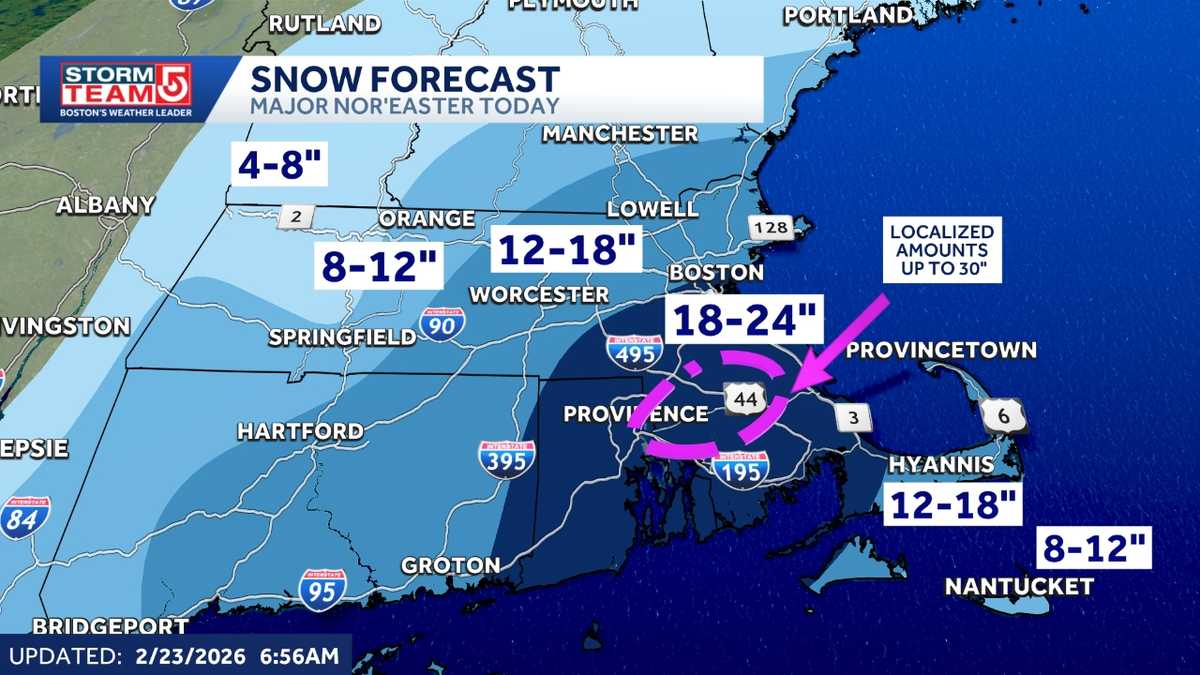
A powerful nor’easter that could bring 2 feet of snow to some parts of Massachusetts that triggered a blizzard warning and prompted the governor to declare a state of emergency is hitting the state Monday.StormTeam 5 tools: Alerts | Futurecast | Map Room | Radar | ClosingsBy 6:15 a.m., nearly 10 inches of snow fell in New Bedford, Massachusetts, as the heaviest bands of snow started moving into the region.”We are just getting into this. We are going to continue to see these intense bands of snow wrapping around the center of our storm through 11 a.m.,” StormTeam 5 Chief Meteorologist Cindy Fitzgibbon said. The state has already recorded 43.3 inches of snow this season and could add another foot and a half to 2 feet from this storm alone. A Blizzard Warning is in effect until 7 a.m. Tuesday for all of eastern and central Massachusetts, extending well beyond I-495 and into parts of western Massachusetts. Blizzard conditions are defined by visibility reduced to a quarter mile or less in falling or blowing snow, along with sustained winds or frequent gusts of at least 35 mph lasting three hours. Bomb cycloneWinds will peak from Monday morning into midday as the barometric pressure of the storm rapidly drops. “The wind, which is ramping up already, won’t peak until midday and won’t come down till about sunset,” Fitzgibbon said.Wind gusts of 70 mph or greater are possible in southeastern Massachusetts, where widespread power outages are possible. Strong winds are also a contributing factor in the definition of blizzard conditions. Dangerous travelWhiteout conditions will make travel nearly impossible across Massachusetts. “I can’t stress this enough. Stay off the roads,” StormTeam 5 Meteorologist David Williams said. The worst of travel will be from early Monday morning through midday, but strong winds and snow will continue, which is why the Blizzard Warning is in place throughout the day. Power outage potentialHeavy, wet snow and powerful winds could knock out electricity and delay repairs.While hundreds of crews were staged across the state by National Grid and Eversource, restoration efforts could be slowed by dangerous conditions. Utility workers operating bucket trucks can typically work only when winds are below 35 miles an hour. Coastal concernsCoastal communities face an added risk of flooding as those winds push water onshore during high tide. A coastal flood warning is in effect south of Boston through Monday morning, along with a flood watch from Monday afternoon to Monday night, while areas from Boston northward are under a coastal flood advisory. After the stormAfter the storm moves out Monday evening, sunshine is expected to return Tuesday with temperatures near freezing.The pattern remains active, with a chance of light snow Wednesday, a break Thursday and snow likely changing to rain Friday as temperatures approach 40 degrees, with milder weather and melting expected next weekend.
EAST BOSTON, Mass. —
A powerful nor’easter that could bring 2 feet of snow to some parts of Massachusetts that triggered a blizzard warning and prompted the governor to declare a state of emergency is hitting the state Monday.
StormTeam 5 tools: Alerts | Futurecast | Map Room | Radar | Closings
By 6:15 a.m., nearly 10 inches of snow fell in New Bedford, Massachusetts, as the heaviest bands of snow started moving into the region.
“We are just getting into this. We are going to continue to see these intense bands of snow wrapping around the center of our storm through 11 a.m.,” StormTeam 5 Chief Meteorologist Cindy Fitzgibbon said.
The state has already recorded 43.3 inches of snow this season and could add another foot and a half to 2 feet from this storm alone.

A Blizzard Warning is in effect until 7 a.m. Tuesday for all of eastern and central Massachusetts, extending well beyond I-495 and into parts of western Massachusetts. Blizzard conditions are defined by visibility reduced to a quarter mile or less in falling or blowing snow, along with sustained winds or frequent gusts of at least 35 mph lasting three hours.
Bomb cyclone
Winds will peak from Monday morning into midday as the barometric pressure of the storm rapidly drops.
“The wind, which is ramping up already, won’t peak until midday and won’t come down till about sunset,” Fitzgibbon said.
Wind gusts of 70 mph or greater are possible in southeastern Massachusetts, where widespread power outages are possible.
Strong winds are also a contributing factor in the definition of blizzard conditions.
Dangerous travel
Whiteout conditions will make travel nearly impossible across Massachusetts.
“I can’t stress this enough. Stay off the roads,” StormTeam 5 Meteorologist David Williams said.
The worst of travel will be from early Monday morning through midday, but strong winds and snow will continue, which is why the Blizzard Warning is in place throughout the day.

Power outage potential
Heavy, wet snow and powerful winds could knock out electricity and delay repairs.
While hundreds of crews were staged across the state by National Grid and Eversource, restoration efforts could be slowed by dangerous conditions. Utility workers operating bucket trucks can typically work only when winds are below 35 miles an hour.
Coastal concerns
Coastal communities face an added risk of flooding as those winds push water onshore during high tide. A coastal flood warning is in effect south of Boston through Monday morning, along with a flood watch from Monday afternoon to Monday night, while areas from Boston northward are under a coastal flood advisory.

After the storm
After the storm moves out Monday evening, sunshine is expected to return Tuesday with temperatures near freezing.
The pattern remains active, with a chance of light snow Wednesday, a break Thursday and snow likely changing to rain Friday as temperatures approach 40 degrees, with milder weather and melting expected next weekend.
