

AccuWeather meteorologists are sounding the alarm for a widespread multi-day severe risk stretching across the central and eastern United States from Sunday afternoon into Monday. Over a dozen states will be at risk for severe thunderstorms.
As the Triple-Treat March Megastorm moves across the central U.S., bringing blizzard conditions and high winds to parts of the Midwest, a large squall line of thunderstorms is expected to stretch along the associated Arctic front as it moves eastward Sunday into Monday. Some of these thunderstorms will be capable of producing destructive winds, tornadoes and torrential downpours.
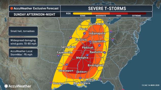
High risk severe weather day on Sunday
The severe risk will begin Sunday afternoon into Sunday night from Texas to southwestern Michigan as the front interacts with surging moisture streaming in from the Gulf.
AccuWeather.com
AccuWeather meteorologists are highlighting a ‘high’ risk for severe storms from northern Louisiana and central Mississippi to portions of southern Illinois and western Kentucky, warning of damaging winds, among other threats.
The main hazard will be widespread damaging wind gusts from 70-80 mph as the squall line moves across the region. Small hail, torrential downpours and even tornadoes can also occur. The AccuWeather Local StormMax™ is 95 mph.
Severe storms across parts of western Kentucky into western Tennessee, including cities such as Paducah, Kentucky; Nashville and Memphis, Tennessee, can occur at night, which can be especially dangerous,” said Senior Meteorologist Dan Pydynowski. “People in these areas should have their phones charged, a NOAA weather radio and audible alerts enabled on the AccuWeather app for when they go to bed at night so they can be woken up to take shelter if damaging winds or tornadoes approach their house.”
AccuWeather.com
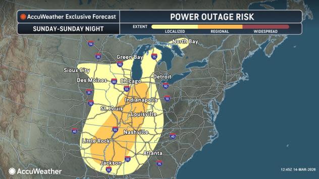
The widespread nature of damaging wind gusts will also raise the risk for power outages and downed trees across the Gulf Coast States and the Ohio Valley.
“One area of particular concern is the southern United States, where communities are still recovering from the major January ice storm, said AccuWeather Chief Meteorologist Jon Porter. “While this type of setup can cause significant tree damage and power outages at any time, the threat may be heightened in this region because many trees and branches could have been weakened by the recent ice storm.”
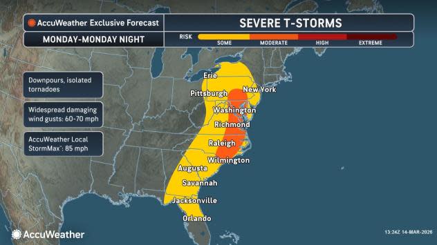
Severe risk shifts east Monday
As the front and associated line of thunderstorms moves eastward towards the Eastern Seaboard, so will the risk for severe weather. At least ‘some’ risk for severe thunderstorms is expected from Florida to New York.
AccuWeather.com
The primary hazard once again will be widespread damaging wind gusts, but there can also be downpours and isolated tornadoes in any severe storms. Winds can gust up to 70 mph with an AccuWeather Local StormMax™ of 85 mph.
Have the app? Unlock AccuWeather Alerts™ with Premium+
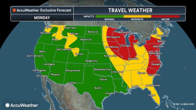
Severe storms could coincide with the evening commute in many metro areas, including Philadelphia, Baltimore, Washington D.C. and Raleigh, further slowing travel times, especially where there is downed trees or power lines. Downpours reducing visibility and causing ponding on roadways can also impact the evening commute. Ground stops can also occur at airports throughout the region.
AccuWeather.com
Want next-level safety, ad-free? Unlock advanced, hyperlocal severe weather alerts when you subscribe to Premium+ on the AccuWeather app. AccuWeather Alerts™ are prompted by our expert meteorologists who monitor and analyze dangerous weather risks 24/7 to keep you and your family safer.