
Chief Meteorologist Darby Bybee is tracking a strong storm system in part of the River Valley. Tornado warnings were issued overnight in Sequoyah, Sebastian, Crawford, and Franklin counties.2:15 a.m.: Emergency management in Crawford County has officers on the way to inspect possible storm damage around the Field of Dreams sports complex. 1:56 a.m.: Darby is tracking “clear circulation” near Hwy 282 north of Van Buren.1:50 a.m.: “Van Buren stay in your safe spots”, Darby said. We’re seeing strong winds and rain along I-40.The tornado warning in Sequoyah county expired at 1:45 a.m.Estimated winds speeds of more than 100 mph were seen on radar on the Arkansas, Oklahoma border near Dora, at 1:40 a.m. “Liberty, Remy, Lone Oak: get in your safe spots”, Darby said at 1:28 a.m.As of 1:22 a.m., a possible tornado was being tracked just north of Muldrow in Sequoyah County. There were wind speeds of greater than 100 mph estimated there.Isolated flash flooding also looks possible. But, for the most part, just some good, much-needed rain for us, with rain totals mostly between 1″ and 2″. Some places could see as much as 3″ to 4″, especially in the River Valley where the heaviest rain is expected to occur.The rain will impact Saturday morning plans for many. But, we will dry out for the remainder of the Easter Weekend! Dry conditions will emerge in NWA by mid or late morning on Saturday, and by late morning or very early afternoon in the River Valley. Saturday afternoon looks dry, though cooler. And Sunday looks beautiful! It may be a little chilly in the morning (and probably a little muddy) for those early Easter egg hunts. And sunny and mild for Easter Sunday afternoon!You can see the 7-day forecast for Northwest Arkansas and the River Valley anytime. We also have an interactive radar and live skycams.Subscribe to 40/29 News on YouTube for the latest weather and news.The 40/29 Get Ready Weather Team includes Chief Meteorologist Darby Bybee and meteorologists Laura Huckabee, Drake Foley and Cole Makos.Be sure to download and personalize the free 40/29 News app to stay safe during severe weather.
FAYETTEVILLE, Ark. —
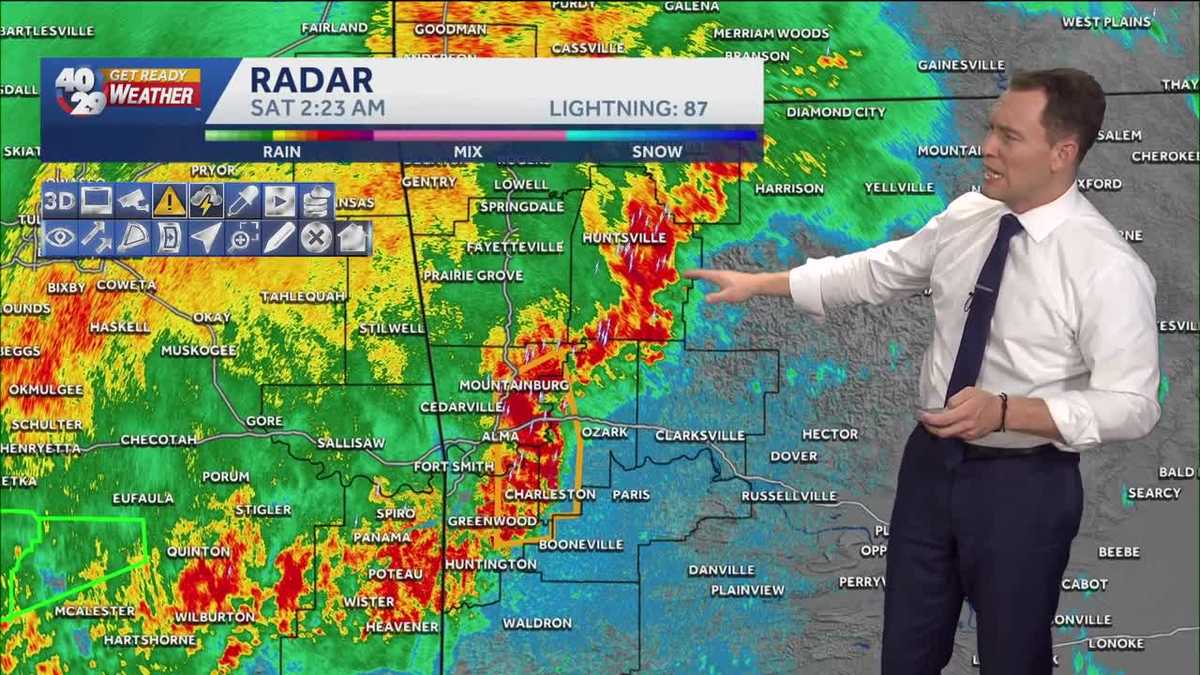
Chief Meteorologist Darby Bybee is tracking a strong storm system in part of the River Valley.
Tornado warnings were issued overnight in Sequoyah, Sebastian, Crawford, and Franklin counties.
2:15 a.m.: Emergency management in Crawford County has officers on the way to inspect possible storm damage around the Field of Dreams sports complex.
1:56 a.m.: Darby is tracking “clear circulation” near Hwy 282 north of Van Buren.

40/29 News
1:58 a.m.: You can see strong winds and rain hitting along I-40 east of Van Buren.
1:50 a.m.: “Van Buren stay in your safe spots”, Darby said. We’re seeing strong winds and rain along I-40.
The tornado warning in Sequoyah county expired at 1:45 a.m.
Estimated winds speeds of more than 100 mph were seen on radar on the Arkansas, Oklahoma border near Dora, at 1:40 a.m.
“Liberty, Remy, Lone Oak: get in your safe spots”, Darby said at 1:28 a.m.
As of 1:22 a.m., a possible tornado was being tracked just north of Muldrow in Sequoyah County. There were wind speeds of greater than 100 mph estimated there.
Isolated flash flooding also looks possible. But, for the most part, just some good, much-needed rain for us, with rain totals mostly between 1″ and 2″. Some places could see as much as 3″ to 4″, especially in the River Valley where the heaviest rain is expected to occur.

The rain will impact Saturday morning plans for many. But, we will dry out for the remainder of the Easter Weekend! Dry conditions will emerge in NWA by mid or late morning on Saturday, and by late morning or very early afternoon in the River Valley. Saturday afternoon looks dry, though cooler.

And Sunday looks beautiful! It may be a little chilly in the morning (and probably a little muddy) for those early Easter egg hunts. And sunny and mild for Easter Sunday afternoon!


You can see the 7-day forecast for Northwest Arkansas and the River Valley anytime. We also have an interactive radar and live skycams.
Subscribe to 40/29 News on YouTube for the latest weather and news.
The 40/29 Get Ready Weather Team includes Chief Meteorologist Darby Bybee and meteorologists Laura Huckabee, Drake Foley and Cole Makos.
Be sure to download and personalize the free 40/29 News app to stay safe during severe weather.