
NATIONAL HURRICANE CENTER
The 5-day forecast for Tropical Storm Henriette.
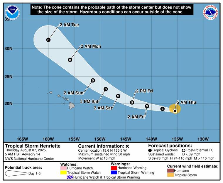
Tropical Storm Henriette remained far east of the Hawaiian Islands early today, as residents enjoy a temporary respite from the muggy, humid conditions slated to return this weekend.
At 5 a.m. the storm’s center was located about 1,462 miles east of Honolulu, moving west at 16 mph with maximum sustained winds of 50 mph, according to the National Hurricane Center in Miami. Henriette is forecast to maintain its strength for the next couple of days before gradually intensifying while turning northwest, keeping the storm’s center well north of Hawaii.
No coastal watches or warnings are in effect, and Henriette poses no direct threat to land at this time. However, its approach is expected to contribute to very warm, humid conditions and increasing interior showers across the islands from Sunday through Monday, the National Weather Service said.
Conditions are expected to stabilize starting Monday afternoon, when drier tradewind weather begins to return.
Meanwhile, minor coastal flooding remains a concern through Saturday afternoon as elevated water levels — running about half a foot higher than predicted — combine with peak afternoon high tides and a large south swell. Flooding of normally dry beaches, saltwater overwash on roadways and minor coastal erosion are possible, especially in vulnerable low-lying shoreline areas.
Weather officials are urging residents to avoid flooded roads, secure boats and watercraft and move valuables to higher ground.
Don’t miss out on what’s happening!
Stay in touch with breaking news, as it happens, conveniently in your email inbox. It’s FREE!