
DO MAKE IT HARDER FOR HURRICANES TO FORM IN THE ATLANTIC GULF COAST WEATHER. >> CERTIFIED MOST ACCURATE. >> AND THEN THERE ARE OTHER AREAS LIKE THE SOUTHWEST. THEY CAN DEAL WITH A LOT OF RAIN. SO EVEN THOUGH WE MIGHT GET SOME OF THE BENEFITS FROM HER FROM NOW ON, YOU KNOW, THERE ARE OTHER AREAS THAT WILL NOT SEE THE BENEFITS WAY TOO MUCH RAIN. DROUGHT. YOU COULD HAVE EXTREME STORMINESS OUT FROM THE JET STREAM GETTING DO LOW. SO IT’S ALL KIND OF DIFFERENT ACROSS THE COMPANY COULD GET MORE OF THOSE EXTREMES WITH YOU SO WE’LL KIND OF TALK ABOUT IT HERE IN JUST A BIT. BUT WHAT ARE WE EXPECTING IN THE NEAR FUTURE? AND WITHOUT NINO, RAINY PATTERN IS GOING TO CONTINUE. WE HAD SOME STORMS TODAY. RAIN IS GOING TO STICK INTO THE FORECAST FOR TOMORROW AND INTO THE WEEKEND. AND WHEN WE SAY THIS IS GOING TO BE A BIG EVENT, IT MEANS IT WILL BE SO FAR OFF FROM THAT AVERAGE SEA SURFACE TEMPERATURE. SO WHEN YOU’RE OVER 2 DEGREES CELSIUS ABOVE WHAT WE TYPICALLY EXPECT IN THIS REGION, THEY’RE GOING TO CALL IT A VERY STRONG EL NINO, SUPER EL NINO IS NOT A TECHNICAL TERM. IT’S NOT A SCIENTIFIC TERM. WAS JUST SAYING, YEAH, WE’RE ON THE TOP END OF THE SCALE HERE IT GOES FROM WEEK. MODERATE SOMEWHAT HURT AND THEN VERY STRONG. SO WE ARE GOING TO BE TRACKING THAT THROUGH THIS SUMMER AND IT WILL LAST INTO THE WINTER KNOW HAVE ITS IMPACTS WITH WINTER, TOO, SOMETIMES WITHOUT NINO WINTERS. WE HAVE A STORMIER WINTER WITH ACTIVE WEATHER THUNDERSTORMS. SO IT ALL IS GOING TO PLAY OUT OVER THE NEXT COMING MONTHS. THE BIGGEST IMPACTS, THE MOST IMMEDIATE IMPACT WILL BE CREATING WIND SHEAR IN THE MAIN DEVELOPMENT REGION THROUGH THE ATLANTIC BASIN, THROUGH BETWEEN WEST COAST OF AFRICA AND THE CARIBBEAN. AND IT’S NOT GOING TO BE EVERYWHERE. THERE WILL BE POCKETS FOR SOME STORMS WILL BE ABLE TO KIND OF FORM THE GREAT HERE. BUT WE’RE NOT EXPECTING SO MANY STORMS THIS YEAR. REMEMBER, IT ONLY TAKES ONE. SO WE’RE GOING TO BE TRACKING THAT. HERE’S OUR FIRST AREA OF INTEREST THAT BUDGE WILL CALL IT A LITTLE LEMON HERE. THIS IS A 10% CHANCE OF DEVELOPING OVER THE NEXT COUPLE OF DAYS AND IT WOULD NOT IMPACT US AT ALL IF YOU IF IT DOES DEVELOP. SO THAT KIND OF A STORMY PATTERN WILL CONTINUE FOR THE NEXT FEW WEEKS. A KIND OF AROUND CENTRAL AMERICA. YOU LOOK OFF INTO THE ATLANTIC BASIN. THERE IS NOTHING. LET’S HOPE THIS HOLDS FOR A WHILE. BUT THEN WHEN YOU GET CLOSER TO CENTRAL AMERICA, THIS IS WHERE WE WILL SEE A LOT OF CONVECTION AND A LOT OF STORMS ARE KIND OF GROW HERE. MOVE OFF TO THE EASTERN PACIFIC. WE WILL EXPECT A MORE ACTIVE EASTERN PACIFIC STORM IN THE ATLANTIC STORM THAT THE LIGHTNING OUT OF THE BEACH. IF YOU HAVE A VIEW OF THE WESTERN HORIZON, YOU’RE GOING WANT TO TAKE A LOOK BECAUSE YOU WILL SEE A LOT OF LIGHTNING STRIKES OVER THE NEXT HOUR OR SO. TEMPERATURES WILL STAY INTO THE 80’S. MOST OF THE RAIN IS STARTING TO FADE AWAY. I’LL SHOW YOU THE RADAR IN JUST A MOMENT. BUT TOMORROW, REPEAT, WE’RE GOING TO DO IT AGAIN. SHOWERS AND THUNDERSTORMS ARE BACK IN THE FORECAST. WE’LL STAY INTO 90’S AND WILL SANTA LOW 90’S ALL NEXT WEEK? VERY LITTLE CHANGE. DAY TO DAY. IT’S HOW MUCH RAIN DO WE SEE EACH AND EVERY AFTERNOON TOMORROW. SEE A GOOD BET AS WELL. HERE’S WHAT’S LEFT OVER OF THE RAIN FOR TONIGHT. AND I’M MOVING OUT INTO THE GULF IN JUST A FEW ISOLATED SHOWERS LEFT OVER. ONCE WE HEAD INTO TOMORROW MORNING AT 2 O’CLOCK COUPLE OF ISOLATED SHOWERS COULD EVEN LINGER AS WE HEAD THROUGH THE AFTERNOON TOMORROW, ONCE AGAIN, SHOWERS AND THUNDERSTORMS BEGINNING TO DEVELOP. AND THEN LOOK AT HERE. YEAH, WE ARE DEALING WITH SOME HEAVY RAIN, POSSIBLY SCATTERED DOWNPOURS AND SOME GUSTY WINDS ASSOCIATED WITH THIS. WE HAD SOME SOME STRONG STORMS WITH SOME HAIL POSSIBLE EARLIER TODAY. THAT COULD BE THE CASE AGAIN FOR TOMORROW. AND THEN IT FADES AWAY AFTER THE SUN SETS ON SATURDAY. AS YOU MAKE YOUR WEEKEND PLANS. SAME STORY. WE’LL SEE ISOLATED SHOWERS BEGIN TO DEVELOP 2 IN ONE AND 4 O’CLOCK. AND THEN AS WE HEAD INTO THE AFTERNOON, WE’LL SEE MORE DOWNPOURS DEVELOP AS WELL. MAYBE NOT AS MANY SHOWERS ON SATURDAY COMPARED TO FRIDAY. THIS BOTH LOWER THAT COVERAGE RATE DOWN TO ABOUT 40% COME SATURDAY. BUT IT WILL BE PRETTY ACTIVE TOMORROW.
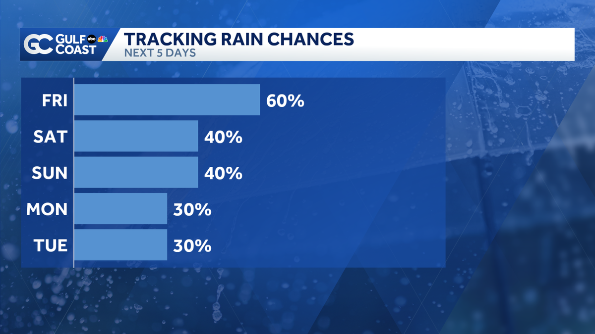
Rain chances stay elevated Friday, slightly drier for the weekend
Temperatures will only drop to the upper 70s by Friday morning.

Updated: 11:27 PM EDT Jun 11, 2026
Isolated showers will linger east of I-75 overnight Thursday. By Friday morning, temperatures will only make it to the upper 70s. Your Gulf Coast Weather Most Accurate Forecast has highs in the low 90s Friday afternoon. Scattered showers and thunderstorms will roll across the Gulf Coast during the evening commute. By the weekend, rain chances drop down to 40% coverage for Saturday and Sunday. It’ll still be hot and humid, though, with highs in the low 90s.Tropics:The National Hurricane Center has marked the southwestern Gulf as an area to watch for tropical development later this week. Remnant energy from Pacific Tropical Storm Cristina could redevelop into a weak tropical depression or storm in the area prior to moving onshore in eastern Mexico by Saturday. Development chances are low, however, at only 10%. Regardless of development, this system poses no threat to Florida.However you watch or scroll, we’re committed to delivering your Gulf Coast Weather Most Accurate Forecast, one you can rely on every day, wherever you are.Live Interactive Radar: Track conditions in real time with the Gulf Coast Live Radar.Watch Gulf Coast Weather: Find the latest weather forecast videos, streaming live or on demand, on TV and online.Stream on the Go: Download the free Gulf Coast News app to watch on your phone or tablet.Your Gulf Coast Weather TeamChief Meteorologist Allyson RaeMeteorologist Caroline CastoraMeteorologist Jim DickeyMeteorologist Lauren HopeMeteorologist Raphael TavernierMeteorologist Rob DunsMeteorologist Sara BlueFollow on Social: Follow, like and subscribe to Gulf Coast News on social media to share your tips and be part of the conversation with Southwest Florida’s most experienced, trusted weather team: Facebook | Instagram | YouTube | TikTok | Threads | Bluesky | Nextdoor | XDOWNLOAD the free Gulf Coast News app for your latest breaking news and weather alerts. And check out the Very Local Gulf Coast app to stream news, entertainment and original programming on your TV.
FORT MYERS, Fla. —
Isolated showers will linger east of I-75 overnight Thursday. By Friday morning, temperatures will only make it to the upper 70s.
Your Gulf Coast Weather Most Accurate Forecast has highs in the low 90s Friday afternoon. Scattered showers and thunderstorms will roll across the Gulf Coast during the evening commute.
By the weekend, rain chances drop down to 40% coverage for Saturday and Sunday. It’ll still be hot and humid, though, with highs in the low 90s.
Tropics:
The National Hurricane Center has marked the southwestern Gulf as an area to watch for tropical development later this week. Remnant energy from Pacific Tropical Storm Cristina could redevelop into a weak tropical depression or storm in the area prior to moving onshore in eastern Mexico by Saturday. Development chances are low, however, at only 10%. Regardless of development, this system poses no threat to Florida.
However you watch or scroll, we’re committed to delivering your Gulf Coast Weather Most Accurate Forecast, one you can rely on every day, wherever you are.
Live Interactive Radar: Track conditions in real time with the Gulf Coast Live Radar.
Watch Gulf Coast Weather: Find the latest weather forecast videos, streaming live or on demand, on TV and online.
Stream on the Go: Download the free Gulf Coast News app to watch on your phone or tablet.
Your Gulf Coast Weather Team
Follow on Social: Follow, like and subscribe to Gulf Coast News on social media to share your tips and be part of the conversation with Southwest Florida’s most experienced, trusted weather team: Facebook | Instagram | YouTube | TikTok | Threads | Bluesky | Nextdoor | X
DOWNLOAD the free Gulf Coast News app for your latest breaking news and weather alerts. And check out the Very Local Gulf Coast app to stream news, entertainment and original programming on your TV.