
Impact Day: Triple-digit feels-like temperatures stick around the Gulf Coast
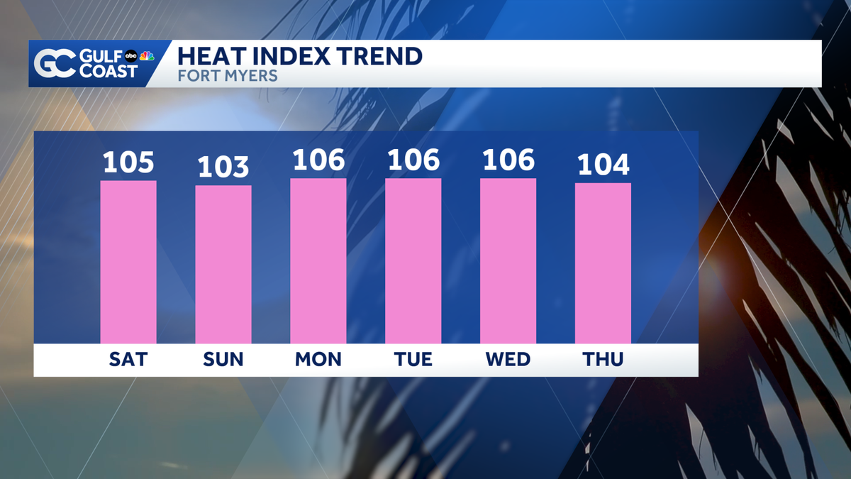
COUNTY. >> ON JEN SULLIVAN REPORTING. >> ANOTHER HOT ONE AND NOT EVERY DAY YOU GET A WEATHER IMPACT DAY WITHOUT MUCH RAIN. THERE IS A LITTLE RAIN IN THE FORECAST. BUT FOR US, IT’S THE HEAT. YOU WALK OUT THE DOOR. YOU NOTICE IT, YOU FEEL IT. AND IF YOU CAN’T REALLY DEAL WITH THE 2, WELL, THAT’S OKAY. I CAN EITHER I KIND OF HATE IT. AND IT’S ONE OF THOSE DAYS THAT YOU WANT TO STAY INSIDE. OUR FEELS LIKE TEMPERATURES COULD BE ANYWHERE FROM 100 TO 5 TO 110. BUT I WILL SAY WE’VE ALREADY SEEN SOME SPOTS EXCEED THAT 110 DEGREE MARK FOR THAT HEAT INDEX. IT’S BECAUSE THE HUMIDITY IS SO HIGHER. DEW POINTS ARE IN THE 80’S IN SOME SPOTS FEELS QUITE TROPICAL OUT THERE AND THAT’S CONTRIBUTING TO WHY IT FEELS SO HOT. ACTUAL TEMPERATURES ARE IN THE LOW 90’S AND UPPER 80’S SO FAR THIS FRIDAY AND WE STILL HAVE A WAYS TO GO BEFORE WE SEE OUR OFFICIAL SEE OUR OFFICIAL HIGH TEMPERATURE FOR THE AFTERNOON IN TERMS OF CURRENT FEELS LIKE TEMPERATURES ACROSS LEE COUNTY. I MENTIONED THAT BEFORE THE BREAK. I WANT TO TALK ABOUT IT AGAIN. GATEWAY 111 IS WHAT IT FEELS LIKE THERE RIGHT NOW. 106 FOR ESTERO BONITA SPRINGS, SAN CARLOS PARK FEELS LIKE 105 DEGREES AT THIS POINT IN CAPE CORAL. AND REMEMBER, WE COULD STILL SEE THOSE FEELS LIKE TEMPERATURES BUMP UP A COUPLE OF MORE DEGREES UP IN CHARLOTTE COUNTY, PORT CHARLOTTE FEEL LIKE 106 SAME THING FOR PIRATE HARBOR AND DEEP CREEK FEELS LIKE 104 OUT THERE IN INGLEWOOD IN ROTUNDA AND THEN FEEL LIKE 107. I’LL STEP OUT OF THE WAY THERE IN BABCOCK RANCH. SO FAR THIS FRIDAY, DOWN TOWARDS COLLIER. WE’RE STILL SEEING THOSE TRIPLE DIGIT FEELS LIKE TEMPERATURES 104 FOR NAPLES, 106 FOR NAPLES PARK VINEYARDS IN GOLDEN GATE ESTATES AS WELL AS LATELY TO THIS FRIDAY. I GUESS WE CAN SAY AFTERNOON THIS POINT OUR HIGH TEMPERATURES WILL NOT REALLY BREAKING RECORDS WERE NOT EXPECTING THAT. IT’S THE HUMIDITY. THAT’S THE PROBLEM. IT’S THE HUMIDITY THAT’S GOING TO CONTRIBUTE TO SOME SPOTS GETTING REAL CLOSE TO 110 FOR WHAT IT COULD FEEL LIKE THIS AFTERNOON. AND THOSE TRIPLE DIGIT FEELS LIKE TEMPERATURES. THEY’RE NOT GOING ANYWHERE THIS WEEKEND, EVEN THOUGH THEY’LL BUMP DOWN JUST A LITTLE BIT. IT’S STILL SOMETHING YOU’RE GOING TO HAVE TO MONITOR AS WE START THE 7 DAY OFF WITH THAT. IN FOR THE REST OF THIS FRIDAY THAT GOES THROUGH 7 SATURDAY AND SUNDAY. WE HAVE AFTERNOON SHOWERS AND THUNDERSTORMS POSSIBLE ESPECIALLY ON SATURDAY, 40% COVERAGE TOWARDS THE BEGINNING OF THE WORKWEEK. WE ACTUALLY BUMP THOSE TEMPERATURES UP A LITTLE BIT MORE 94. I MIGHT EVEN MOVE THAT NUMBER A LITTLE BIT HIGHER FLOOR MONDAY, RAIN CHANCE ONLY 20% TO START THE WEEK UP FOR BUILDS RIGHT BACK IN TOWARDS THE END OF THE FORECAST PERIOD. NOW, SPEAKING OF RAIN, WE HAVE A FEW LITTLE CELLS ON THE RADAR SO FAR THIS FRIDAY. BUT HERE’S WHAT WE’RE WORKING WITH. WE HAD ONE THAT WAS BUBBLING UP THERE IN BONITA SPRINGS, MAINLY ALONG. 75 THAT HAS SINCE WASHED OUT. I WAS SHOWING YOU THAT BECAUSE THE NATURE OF THE RAIN THAT HAVE ON THE RADAR RIGHT NOW, IT’S HERE ONE SECOND. IT’S THERE. IT’S GONE. 15 MINUTES LATER. WE HAVE A LITTLE BIT OF RAIN UP TOWARDS GLADES COUNTY AS WELL AS NORTHERN CHARLOTTE COUNTY THERE, TOO. WE’RE GONNA KEEP AN EYE ON THOSE THAT JUST WANT TO STRIKES OF LIGHTNING ASSOCIATED WITH THAT VERY, VERY SMALL POCKET OF RAIN THAT WE HAVE. THE MAIN EVENT WILL BE HERE UNTIL THIS AFTERNOON AND WILL LIKELY IMPACT PARTS OF GLADES AND HENDRY COUNTY WITH A LOW AND SEVERE WEATHER THREAT AS WELL. THIS BY ABOUT ONE, 30, MAYBE A CELL UP TOWARDS DESOTO COUNTY. THE MODELS ARE NOT PICKING UP ON THE VERY SMALL HIT OR MISS SHOWERS LIKE WHAT WE’RE SEEING AS OF RIGHT NOW, I WOULD EXPECT THAT TO PERSIST EVEN AS WE WAIT FOR THE HIGHER RAIN CHANCES TO BUILD BACK IN THIS BY ABOUT 4.30, THIS IS BY THE TIME WE GET TO 6.30, LOOK OUT TOWARDS WE SEE A POCKET OF HEAVY, HEAVY RAIN THAT COMES WITH THE SEVERE WEATHER RISK AS WELL WHERE WE COULD SEE THE POTENTIAL FOR SOME GUSTY WINDS, FREQUENT LIGHTNING, MAYBE EVEN SMALL HAIL ASSOCIATED WITH THE POCKETS OF RAIN. THE TRY TO A TAX FIGHT OUT TOWARDS BY 7.30 AND THEN WE HAD 8, 30, 30. THE RAIN. CHANCES SHOULD START TO BREAK
Impact Day: Triple-digit feels-like temperatures stick around the Gulf Coast

Updated: 3:04 PM EDT Jun 19, 2026
The heat and humidity aren’t going anywhere this weekend. Expect triple-digit feels-like temperatures with afternoon rain chances each day.Your Gulf Coast Weather Most Accurate Forecast has temperatures reaching the low 90s Saturday afternoon, but feels-like temperatures will likely exceed 105 degrees. Sunday’s temperature trend looks to be similar.In terms of rain chances, expect higher coverage Saturday, where scattered showers and thunderstorms will develop in the afternoon hours.Tropics: The remnants of Arthur are no longer expected to redevelop thanks to strong upper-level winds. It will then merge with a front that will take it farther out to sea over cooler waters.WEATHER ARTICLE END TEXTHowever you watch or scroll, we’re committed to delivering your Gulf Coast Weather Most Accurate Forecast, one you can rely on every day, wherever you are.Live Interactive Radar: Track conditions in real time with the Gulf Coast Live Radar.Watch Gulf Coast Weather: Find the latest weather forecast videos, streaming live or on demand, on TV and online.Stream on the Go: Download the free Gulf Coast News app to watch on your phone or tablet.Your Gulf Coast Weather TeamChief Meteorologist Allyson RaeMeteorologist Caroline CastoraMeteorologist Jim DickeyMeteorologist Lauren HopeMeteorologist Raphael TavernierMeteorologist Rob DunsMeteorologist Sara Blue Follow on Social: Follow, like and subscribe to Gulf Coast News on social media to share your tips and be part of the conversation with Southwest Florida’s most experienced, trusted weather team: Facebook | Instagram | YouTube | TikTok | Threads | Bluesky | Nextdoor | XDOWNLOAD the free Gulf Coast News app for your latest breaking news and weather alerts. And check out the Very Local Gulf Coast app to stream news, entertainment and original programming on your TV.
FORT MYERS, Fla. —
The heat and humidity aren’t going anywhere this weekend. Expect triple-digit feels-like temperatures with afternoon rain chances each day.
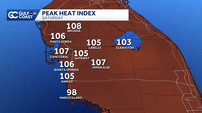
Your Gulf Coast Weather Most Accurate Forecast has temperatures reaching the low 90s Saturday afternoon, but feels-like temperatures will likely exceed 105 degrees. Sunday’s temperature trend looks to be similar.
In terms of rain chances, expect higher coverage Saturday, where scattered showers and thunderstorms will develop in the afternoon hours.
Tropics: The remnants of Arthur are no longer expected to redevelop thanks to strong upper-level winds. It will then merge with a front that will take it farther out to sea over cooler waters.
WEATHER ARTICLE END TEXT
However you watch or scroll, we’re committed to delivering your Gulf Coast Weather Most Accurate Forecast, one you can rely on every day, wherever you are.
Live Interactive Radar: Track conditions in real time with the Gulf Coast Live Radar.
Watch Gulf Coast Weather: Find the latest weather forecast videos, streaming live or on demand, on TV and online.
Stream on the Go: Download the free Gulf Coast News app to watch on your phone or tablet.
Your Gulf Coast Weather Team
Follow on Social: Follow, like and subscribe to Gulf Coast News on social media to share your tips and be part of the conversation with Southwest Florida’s most experienced, trusted weather team: Facebook | Instagram | YouTube | TikTok | Threads | Bluesky | Nextdoor | X
DOWNLOAD the free Gulf Coast News app for your latest breaking news and weather alerts. And check out the Very Local Gulf Coast app to stream news, entertainment and original programming on your TV.