

The dangerous heat sticks around through the rest of the week. A look at the updated forecast here.
COPYRIGHT 2026 BY CHANNEL 3000. ALL RIGHTS RESERVED. THIS MATERIAL MAY NOT BE PUBLISHED, BROADCAST, REWRITTEN OR REDISTRIBUTED.
Download the First Warn Weather app here
WHAT WE’RE TRACKING:
ALERT DAYs: Through Friday for dangerous heatWill feel between 100 and 110° each dayA few storm chances this week, mainly north

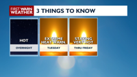
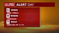
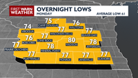
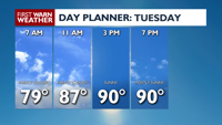
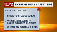
NEXT 24 HOURS: Weather conditions are going to remain breezy and hot overnight Monday into Tuesday as southern Wisconsin continues to sit under a heat dome; lows will likely struggle to dip below 80°F (normal low is 61°F). Temperatures climb back into the low to mid 90s on Tuesday with breezy, southerly winds and humid conditions. Remember to limit your time and your pets time outdoors, drink plenty of water and check in on those who may be more affected by the prolonged heat like the elderly.
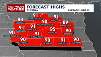
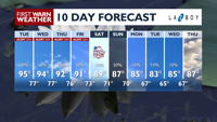
EXTENDED FORECAST: The dangerous heat sticks around through the rest of the week, with highs hanging steady in the low to mid 90s. While still above average, beginning on the Fourth there’ll be a chance for showers and thunderstorms. These storms will help break down the heat dome as we go into the rest of the weekend into the start of the following work week. Temperatures will dip into the low to mid 80s from Monday through Wednesday of next week.
COPYRIGHT 2026 BY CHANNEL 3000. ALL RIGHTS RESERVED. THIS MATERIAL MAY NOT BE PUBLISHED, BROADCAST, REWRITTEN OR REDISTRIBUTED.
COPYRIGHT 2026 BY CHANNEL 3000. ALL RIGHTS RESERVED. THIS MATERIAL MAY NOT BE PUBLISHED, BROADCAST, REWRITTEN OR REDISTRIBUTED.
Humidity: 92%
Feels Like: 77°
Heat Index: 77°
Wind: 9 mph
Wind Chill: 77°
UV Index: 9 Very High
Sunrise: 05:21:51 AM
Sunset: 08:41:30 PM
Dew Point: 75°
Visibility: 10 mi
Today
Hot and humid. Wind: SW 10-15 MPH.
Tonight
Mostly clear to party cloudy with a slight chance for showers and thunderstorm. Wind: SW 10-15 MPH.
Tomorrow
Mostly sunny, hot and humid. Wind: S 10 MPH.
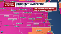
Extreme Heat Warning until WED 7:00 PM CDT
…EXTREME HEAT WARNING REMAINS IN EFFECT UNTIL 7 PM CDT WEDNESDAY…
* WHAT…Dangerously hot conditions with daytime heat index values
up to 106 degrees today and Wednesday, with overnight heat index
values in the upper 70s.
* WHERE…Portions of east central, south central, and southeast
Wisconsin.
* WHEN…Until 7 PM CDT Wednesday.
* IMPACTS…Heat related illnesses increase significantly during
extreme heat and high humidity events.
PRECAUTIONARY/PREPAREDNESS ACTIONS…
Drink plenty of fluids, stay in an air-conditioned room, stay out of
the sun, and check up on relatives and neighbors.
Take extra precautions when outside. Wear lightweight and loose
fitting clothing. Try to limit strenuous activities to early morning
or evening. Take action when you see symptoms of heat exhaustion and
heat stroke.
Stay cool, stay hydrated, stay informed.
&&
Tue
Tuesday
95°/77°
Mix of sun and clouds. Highs in the low 90s and lows in the mid 70s.
Tuesday Night
Mostly clear to party cloudy with a slight chance for showers and thunderstorm. Wind: SW 10-15 MPH.
Wed
Wednesday
94°/77°
Partly cloudy. Highs in the low 90s and lows in the mid 70s.
Wednesday Night
Partly cloudy with a chance for showers and thunderstorms.
Thu
Thursday
92°/76°
Showers and thunderstorms late. Highs in the mid 80s and lows in the low 70s.
Thursday Night
Mostly clear and partly cloudy with a slight chance for showers and thunderstorms.
Fri
Friday
91°/73°
Thunderstorms. Highs in the low 80s and lows in the upper 60s.
Friday Night
Mostly clear to partly cloudy.
Sat
Saturday
89°/71°
A few thunderstorms possible. Highs in the low 80s and lows in the mid 60s.
Saturday Night
Mostly cloudy with scattered showers and thunderstorms.
Sun
Sunday
87°/70°
Mostly cloudy. Highs in the low 80s and lows in the mid 60s.
Sunday Night
Partly cloudy.
Mon
Monday
85°/67°
Mix of sun and clouds. Highs in the low 80s and lows in the mid 60s.
Monday Night
Mostly clear.
Tue
Tuesday
83°/65°
Mix of sun and clouds. Highs in the mid 80s and lows in the mid 60s.
Tuesday Night
Mostly clear.
Wed
Wednesday
85°/67°
Partly cloudy. Highs in the mid 80s and lows in the mid 60s.
Wednesday Night
Mostly clear.
Thu
Thursday
87°/63°
Times of sun and clouds. Highs in the mid 80s and lows in the mid 60s.
Thursday Night
Partly cloudy skies. Low 63F. Winds light and variable.