

ALERT DAYs are expected Monday through Wednesday due to hot temperatures and humidity. How hot temperatures will get and how hot the feels like will be next week here.
COPYRIGHT 2026 BY CHANNEL 3000. ALL RIGHTS RESERVED. THIS MATERIAL MAY NOT BE PUBLISHED, BROADCAST, REWRITTEN OR REDISTRIBUTED.
Download the First Warn Weather app here
WHAT WE’RE TRACKING:
Patchy fog possible Sunday night into MondayALERT DAYs: Monday through Wednesday for heatLimited rain chances over the next 10 days

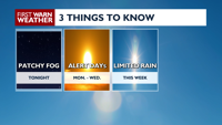
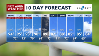
NEXT 24 HOURS: High pressure will continue to sit overhead; with light winds, temperatures are only going to dip into the upper 60s/low 70s with some patchy fog possible. Temperatures climb back into the low to mid 90s on Monday with feels like temperatures (heat index values) in the mid to upper 90s. A few low 100s may be possible but widespread low 100 heat index values are not expected on Monday.
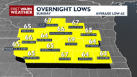
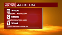
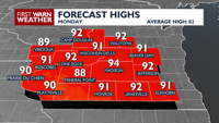
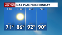
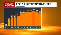
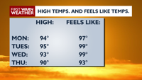
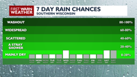
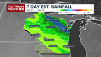
EXTENDED FORECAST: ALERT DAY conditions will continue through, at least, Wednesday of next week. High temperatures will remain in the low to mid 90s through Thursday however, the dangerous feels like temperatures will likely stick around on both Tuesday and Wednesday. Because of this high pressure system, there will be limited rain chances next week; the best chance for rain, while isolated, will be Wednesday.
COPYRIGHT 2026 BY CHANNEL 3000. ALL RIGHTS RESERVED. THIS MATERIAL MAY NOT BE PUBLISHED, BROADCAST, REWRITTEN OR REDISTRIBUTED.
COPYRIGHT 2026 BY CHANNEL 3000. ALL RIGHTS RESERVED. THIS MATERIAL MAY NOT BE PUBLISHED, BROADCAST, REWRITTEN OR REDISTRIBUTED.
Humidity: 79%
Feels Like: 68°
Heat Index: 68°
Wind: 2 mph
Wind Chill: 68°
UV Index: 0 Low
Sunrise: 05:29:44 AM
Sunset: 08:37:29 PM
Dew Point: 61°
Visibility: 10 mi
Today
Mostly clear to clear, muggy with some patchy fog possible. Wind: W 5 MPH.
Tonight
Mostly clear to clear, muggy with some patchy fog possible. Wind: W 5 MPH.
Tomorrow
Mostly sunny and very warm. Wind: W 5 MPH.
Sun
Sunday
89°/69°
Clear. Lows overnight in the mid 60s.
Sunday Night
Mostly clear to clear, muggy with some patchy fog possible. Wind: W 5 MPH.
Mon
Monday
94°/72°
Abundant sunshine. Highs in the low 90s and lows in the upper 60s.
Monday Night
Mostly clear and warm. Wind W 5 MPH
Tue
Tuesday
95°/73°
Sunshine. Highs in the upper 90s and lows in the low 70s.
Tuesday Night
Mostly clear to partly cloudy and muggy.
Wed
Wednesday
93°/70°
Partly cloudy. Highs in the upper 90s and lows in the low 70s.
Wednesday Night
Partly cloudy to mostly clear and muggy.
Thu
Thursday
90°/69°
Mostly sunny. Highs in the mid 90s and lows in the low 70s.
Thursday Night
Partly cloudy to mostly clear.
Fri
Friday
89°/70°
Partly cloudy. Highs in the low 90s and lows in the low 70s.
Friday Night
Mostly cloudy.
Sat
Saturday
87°/71°
Times of sun and clouds. Highs in the low 90s and lows in the upper 60s.
Saturday Night
Partly cloudy and breezy with a slight chance for showers and thunderstorms.
Sun
Sunday
88°/72°
Times of sun and clouds. Highs in the upper 80s and lows in the upper 60s.
Sunday Night
Mostly to partly cloudy.
Mon
Monday
85°/69°
Times of sun and clouds. Highs in the mid 80s and lows in the mid 60s.
Monday Night
Partly cloudy and breezy.
Tue
Tuesday
85°/65°
More sun than clouds. Highs in the low 80s and lows in the low 60s.
Tuesday Night
Partly cloudy to mostly clear.