
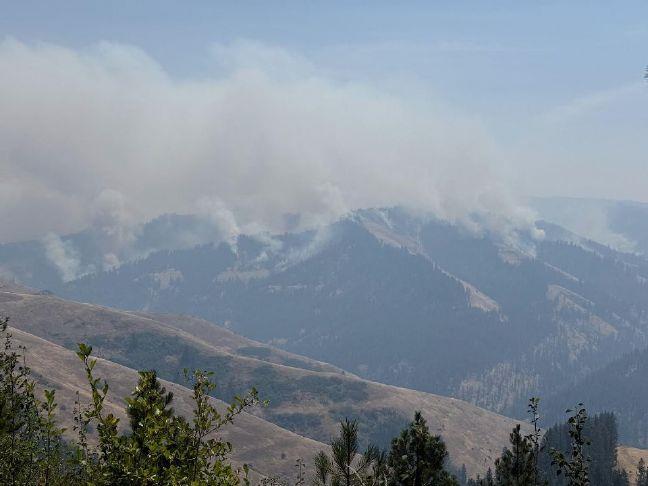
Umatilla County upgrades Hagan Fire evacuation levels
Published 3:39 pm Sunday, July 19, 2026
UMATILLA COUNTY — The Northwest Incident Management Team 7, an interagency complex incident management team, took command of four wildfires on the Umatilla National Forest at 6 a.m. Sunday, July 19. The team will assist and coordinate numerous firefighting resources as they work to suppress and extinguish the lightning-caused fires as quickly and safely as possible.
The fires under Team 7’s command are the Paradise Fire, burning about 10 miles southeast of Walla Walla; the Hagen Fire, burning about 9 miles southwest of Tollgate; the Horse Ridge Fire, burning about 5 miles northeast of Meacham; and the Ninemile Fire, 4 miles southwest of Tollgate within the North Fork Umatilla Wilderness.
The Umatilla County Sheriff’s Office and Umatilla County Emergency Operation Center in cooperation with the Confederated Tribes of the Umatilla Indian Reservation has issued the following evacuation notices immediately for the Hagan Fire.
LEVEL 1 (BE READY)
Evacuation Zones
UMC 151-F
UMC 151-H
UMC 151-G
UMC 151-D
UMC 155-A
UMC 155-B
UMC 157
UMC 215-A
UMC 215-E
UMC 1406007-B
Affected Area
The Level 1 evacuation area extends from the intersection of Wildhorse Road and Abel Road, north to Highway 204, and east to National Forest Road 37-15. This includes all areas north of Wildhorse Mountain and Grouse Mountain to Highway 204, between Wildhorse Road and National Forest Road 37-15.
Residents in these areas should stay informed of current fire conditions, monitor official emergency information sources, and be prepared to evacuate if conditions worsen.
LEVEL 2 (BE SET)
Evacuation Zones:
UMC 149-C
UMC 149-B
UMC 215-D
UMC 1406015-D
UMC 1406015-C
UMC 1406015-A
Affected Area
The Level 2 evacuation area includes Bingham Road from the Confederated Tribes of the Umatilla Indian Reservation boundary to Meacham Creek. It also includes all areas south of Wildhorse Road, between Reed Road and Hawley Road, extending east to the intersection of Abel Road and Bell Road.
Residents under a Level 2 evacuation should be prepared to leave at a moment’s notice. Those who require additional time to evacuate, including individuals with livestock, mobility concerns, or other special needs, should consider evacuating now.
LEVEL 3 – GO NOW!
Affected Area
The Level 3 evacuation area includes Bingham Road and Umatilla River Corridor and Hagen Creek area.
Residents Urged to Exercise Extreme Vigilance Amid Changing Fire Conditions
We are instructing residents in all these areas to take extra precautions. While every effort is being made to provide timely updates on evacuation levels and fire behavior, local terrain presents significant communication and access challenges. Due to the remote nature of these affected areas, residents must remain extremely vigilant and proactively monitor surrounding fire activity. Fire conditions can change rapidly and unpredictably.
Key Hazards in Affected Areas
• Access Limitations: Narrow roadways with limited ingress, egress, and vehicle turnaround space.
• Evacuation Risks: Few alternative routes available if main roads are compromised.
• High Risk Factors: Heavy surrounding vegetation (fuel) that accelerates fire spread.
• Communication Gaps: Potential delays in receiving official alerts due to remote geography.
Recommended Actions for Residents
1. Stay Alert: Do not wait for an official evacuation order if you feel unsafe or see immediate danger.
2. Prepare Early: Keep vehicles fueled, packed with essentials, and facing toward the exit route.
3. Monitor Local Channels: Keep a battery-powered radio handy and check official updates whenever connectivity allows.
Safety remains the top priority. Act early, stay aware, and prioritize life safety above all else.
Continue to follow official fire updates at Paradise, Hagen and Horse Ridge Fire. The most current evacuation Levels for Umatilla County can be found on our webpage Emergency Advisories— Umatilla County including an evacuation map.
The The Northwest Incident Management Team 7 reported firefighters are using full suppression tactics and strategies that provide the highest likelihood of success while mitigating risks to responders. Values at risk include human safety, structures and communities, municipal watersheds, railroad corridors, private timber and range lands, and recreation opportunities.
The team is working to establish a command post in Walla Walla and another operating base for firefighters closer to the Hagen and Horse Ridge Fires. More information will be shared in the coming days via email and on the platforms listed above, such as operational firefighting updates, maps, closures and evacuations, and weather, smoke and fire behavior updates.