
UPDATE: 8:40 p.m.
Hurricane Fausto is expected to weaken to a tropical storm as it approaches Hawaii early next week, but forecasters are urging residents to continue monitoring the system because even small changes in its track could affect the islands.
The National Weather Service in Honolulu said this evening that a strong high-pressure system north of the state will keep moderate to breezy trade winds in place through Monday before Fausto approaches the islands.
The latest forecast continues to bring the center of Fausto north of the island chain Tuesday into Wednesday while weakening. However, forecasters cautioned that subtle shifts in the storm’s track or intensity could change potential impacts from island to island.
“The latest forecast for Fausto shows a weakening trend to tropical storm strength as it moves closer to the island chain,” the weather service said. “Subtle shifts in the storm’s track or intensity will lead to forecast changes in island-by-island weather impacts.”
Forecasters said the greatest concerns remain elevated surf along east-facing shores, periods of heavy rain and locally strong winds if the storm tracks closer to the state.
Don’t miss out on what’s happening!
Stay in touch with breaking news, as it happens, conveniently in your email inbox. It’s FREE!
East shore surf is expected to rise above advisory levels beginning late Sunday and continue through Tuesday as swells generated by Fausto reach the islands.
The National Weather Service is encouraging residents to use the weekend to review hurricane preparedness plans and ensure households have enough food, water and other essential supplies to be self-sufficient for up to 14 days if needed.
Away from Fausto, Hawaii is expected to see typical trade wind weather through the weekend, with passing showers favoring windward and mauka areas, especially overnight and during the early morning hours.
5 p.m.
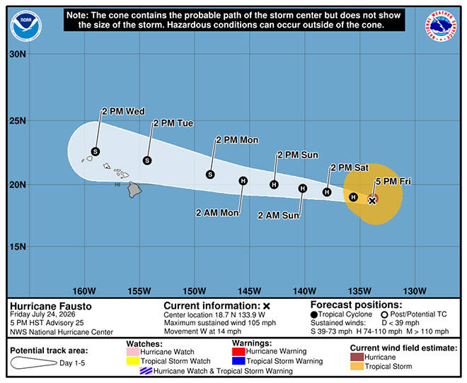
Hurricane Fausto maintained its strength as a Category 2 storm this afternoon, but forecasters expect it will begin to weaken this weekend as it continues on a track that should bring it just north of the islands early next week.
At about 5 p.m., Fausto was centered 1,385 miles east of Hilo with maximum sustained winds of 105 mph, moving west at 14 mph, forecasters said. Hurricane-force winds extend up to 45 miles from the center, and tropical storm-force winds extend up to 205 miles.
The storm is now forecast to still be a hurricane when it enters the Central Pacific on Sunday but weaken to a tropical storm by Monday. On Tuesday, the forecast has Fausto starting its pass north of the islands as a weakening tropical storm with 50 mph maximum sustained winds.
”Although Fausto is expected to weaken as it approaches the Hawaiian islands early next week, uncertainty remains regarding its exact track and intensity,” according to the National Hurricane Center. “The current forecast brings the center just north of the islands, but a track farther south would result in a greater risk of stronger winds and heavier rainfall. Interests across Hawaii should continue to monitor the progress of Fausto.”
Hawaii island is no longer in the forecast map’s so-called cone of uncertainty, but all other islands are inside the cone.
Forecasters said “confidence is high” that swells from Fausto will reach Hawaii ahead of the storm, producing increasing surf and dangerous rip currents. The storm-generated surf is expected to begin building across east shores of the eastern islands by Sunday, then spreading west Sunday night into Monday. Surf should continue building through Tuesday, officials said.
Further east, Tropical Storm Genevieve has 50 mph winds and was about 570 miles south of central Mexico and moving west-northwest far from land. It is forecast to grow into a major Category 3 hurricane by Monday before weakening still over the East Pacific.
>> RELATED STORY: City urges residents to prepare as Fausto nears Central Pacific
11 a.m.
Hurricane Fausto remains a Category 2 storm today while moving steadily west toward the Central Pacific, with forecasters saying the overall outlook for Hawaii has changed little since this morning.
As of 11 a.m., Fausto was centered about 1,460 miles east of Hilo with maximum sustained winds of 105 mph and was moving west at 15 mph, according to the National Hurricane Center in Miami.
The NHC said Fausto is expected to continue moving west for the next several days while gradually weakening over cooler ocean waters in an area with stronger wind shear.
There are still no coastal watches or warnings in effect, but the hurricane center said Hawaii residents should continue monitoring the storm’s progress.
The National Weather Service in Honolulu said its forecast remains largely unchanged, with Fausto expected to weaken into a tropical storm — or possibly a remnant low — as it approaches the islands early to mid next week.
Forecast confidence remains highest for marine impacts rather than direct wind or rainfall.
Weather officials continue to expect long-period swells generated by Fausto to begin arriving late Saturday, with east-facing shores likely reaching advisory-level surf Sunday or Monday. The largest surf is still expected Tuesday or Wednesday, depending on the storm’s eventual track and strength.
Meanwhile, a second tropical system has formed well to the southeast of Fausto. Tropical Depression Seven-E strengthened into Tropical Storm Genevieve today and was packing 45 mph sustained winds about 585 miles south of Zihuatanejo, Mexico, according to the NHC. Genevieve was moving west-northwest at 13 mph and is forecast to continue on that track over the next several days.
Forecasters expect Genevieve to strengthen significantly, with the storm likely reaching hurricane intensity over the weekend as it remains over the open waters of the East Pacific. There are currently no coastal watches or warnings in effect, and the NHC said the storm poses no threats to land at this time.
PREVIOUS COVERAGE
Hurricane Fausto strengthened into a Category 2 storm today while continuing west across the East Pacific, prompting forecasters to urge Hawaii residents to monitor its progress even as the system is expected to weaken before reaching the islands next week.
At 5 a.m., Fausto was centered about 1,560 miles east of Hilo with maximum sustained winds of 105 mph and was moving west near 16 mph, according to the National Hurricane Center in Miami.
The NHC said gradual weakening is expected during the next several days, but Hawaii residents should continue monitoring the hurricane’s progress.
Current forecasts call for Fausto to cross into the Central Pacific this weekend before weakening to a tropical storm or possibly a remnant low as it approaches Hawaii early to mid next week.
The National Weather Service in Honolulu said the latest forecast continues to show Tropical Storm Fausto, or its remnants, skirting north across the western half of the main Hawaiian islands in the middle of next week.
Forecasters cautioned that uncertainty remains over the storm’s eventual strength and track.
“The risk of some impacts from wind and rainfall is increasing,” the National Hurricane Center said Thursday night. “However, it is too soon to determine the exact location or magnitude of these impacts.”
Honolulu forecasters said Fausto is expected to weaken as it encounters cooler sea surface temperatures, stronger wind shear and drier air before reaching the Central Pacific.
While uncertainty remains regarding wind and rainfall, confidence is increasing that Fausto will generate large east shore surf beginning late Saturday.
The National Weather Service said long-period swell from Fausto is expected to produce advisory-level surf along east-facing shores Sunday or Monday, with the largest waves expected Tuesday or Wednesday depending on the storm’s eventual track.
In the meantime, a separate long-period south-southwest swell continues to produce hazardous surf along south-facing shores.
A high surf advisory remains in effect through 6 p.m. today for south-facing shores statewide, where surf of 8 to 12 feet is expected this morning before lowering to 7 to 10 feet this afternoon. Forecasters said another pulse of south swell this weekend could require the advisory to be extended.
Strong breaking waves and dangerous currents will make swimming hazardous along south shores, the weather service said.
Breezy to strong tradewinds also continue across the state.
A small craft advisory remains in effect through 6 p.m. today for most Hawaiian waters due to east winds of 15 to 25 knots. The advisory has been extended through 6 a.m. Sunday for typically windier waters around Maui County and Hawaii island, where winds of 25 to 30 knots are expected.
Away from Fausto, Hawaii’s weather is expected to remain relatively typical through the weekend, with breezy to locally windy trades carrying scattered showers into windward and mauka areas while leeward communities remain mostly dry.
High temperatures are forecast to reach the mid-80s to lower 90s statewide.