
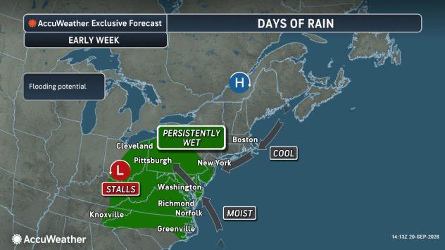
A storm is forecast to form and strengthen into a nor’easter along the mid-Atlantic coast this week. Depending on its track and intensity, gusty winds and erosive surf could accompany heavy rain in the coastal Northeast later this week.
Since late last week, storms have been moving east along a frontal zone stretching from the northern and central Plains to the Midwest. Downpours from this series of storms recently reached the mid-Atlantic coast.

“As a large buckle develops in the jet stream due to a blocking pattern, the storms moving through the Midwest will stall,” AccuWeather Senior Meteorologist Chad Merrill said.
This setup will cause clouds, drizzle, fog and drenching rain to persist from the Carolinas to Ohio, Pennsylvania and New Jersey into Tuesday. Enough rain may fall to trigger flash flooding and travel delays.
“As the dip in the jet stream becomes more pronounced, a new storm is forecast to form either along the coast or up to a couple of hundred miles offshore,” Merrill explained.

The closer to the coast the storm forms and strengthens into a nor’easter, the greater the risk of heavy rain, strong winds and pounding surf. The storm may initially move out to sea then drift west and return closer to the coast later this week.
A track close to the coast could produce enough rain to cause flooding, especially in areas that have been drenched since Saturday night.
“The rain could extend far enough north to ease the ongoing drought in Maine,” Merrill said. “Regardless of how close to the coast the storm tracks, it has the potential to become strong enough to bring rain and gusty winds in coastal areas, while prolonged rough surf may cause above-normal tides and beach erosion.”

A full-blown nor’easter could lead to major travel disruptions due to flooding rain, wind gusts that could trigger power outages and significant coastal flooding.
The full moon will raise astronomical tide levels later this week, and the storm could push water levels even higher.

Coastal flooding, especially around high tide, is likely from North Carolina to New York from Tuesday through Friday. The threat may persist along the northern mid-Atlantic coast and expand into southeastern New England this weekend.
Depending on the storm’s strength, dangerously rough seas could develop offshore, potentially rivaling those produced by a hurricane or midwinter nor’easter. Small-craft operators are urged to closely monitor the forecast.
“Regardless of the severity of the nor’easter, there will be no shortage of cool autumn air in the Northeast, especially over the Appalachians this week,” Merrill said.

Highs will generally range from the 50s to the 60s Fahrenheit in the mountains and from the 60s to lower 70s near the coast.
Autumn officially will arrive at 8:05 p.m. EDT on Tuesday.
Want next-level safety, ad-free? Unlock advanced, hyperlocal severe weather alerts when you subscribe to Premium+ on the AccuWeather app. AccuWeather Alerts™ are prompted by our expert meteorologists who monitor and analyze dangerous weather risks 24/7 to keep you and your family safer.