>> AND THIS MORNING AS IT IS NOW CATEGORY 4. BUT IT IS PICKING UP SOME STRENGTH THIS MORNING. GOOD MORNING, GULF COAST. THANK YOU FOR JOINING US HERE ON YOUR TURDAY MORNING. A MERCEDES MARTINEZ AND I’M SAMANTHA MOMENTUM. SO CAROLINE KUSTURA, SHE’S BEEN TRACKING THISAJOR HURRICANE HERE. SO CAROLINE. >> IT’S ONLY GETTING STRONGER IT IS THIS MORNING. IT’S BEEN VERY BUSY NIGHT. MENTIONED A COUPLE MINUTES AGO THAT I WAS TELLING YOU THAT I WOULDN’T BE SURPRISED IF IT MADE A RUN FOR AT CATEGORY 5 STRENGTH WITH THE MOST RECENT UPDATE ON THE MOST RECENT UPDATE JUST CAME OUT. THEY HELD IT JUST BELOW CAT 5 STRENGTH, BUT THEY BUMPED UP THE INTENSITY FORECAST DOWN THE LINE. IT DOES HAVE IT BECOMING A CATEGORY 5 STORM. >> LATER ON TODAY. SO YESTERDAY IT WAS STILL A TROPICAL STORM. IT BECAME A CATEGORY ONE HURRICANE LAST NIGHT. SO THE FACT THAT IT MADE SUCH A JUMP SUCH RAPID INTENSIFICATION IS VERY, VERY INTERESTING WITH THIS OVERALL TRACK FOR THE STORM. YOU CAN SEE THOSE FIVES ADDED ON. YOU NEVER LIKE TO SEE THAT. HOWEVER, THE TRACK ONCE AGAIN IS BEST CASE SCENARIO BECAUSE DID OVER OPEN WATER. YES, PLACES LIKE PUERTO RICO WILL STILL SEE SOME HEY RAIN FROM THIS. SOME GUSTY WINDS AS WELL. BUT THEY SHOULD STAY AWAY FROM THE WORST OF HURRICANE ERIN. AND SO SHOULD THE BAHAMAS IN THE BUNCH OF OTHER ISLANDS OUT THERE IN THE ATLANTIC. BERMUDA IS ONE TO WATCH, THOUGH, BECAUSE IT IS FURTHER INTO THE FUTURE AND INTO THE CONE OF UNCERTAINTY. BUT THEY HAVE TI AND IT DOES HAVE IT OUTSIDE OF BERMUDA AT THIS POINT. BUT I WAS WAITING FOR THIS UPDATE BECAUSE THIS UPDATE A BUMP. THOSE WIND EEDS UP TO 155 MILES PER HOUR. THE PRESSURE 923 MILLIBARS WITH THIS UPDATE. IT JUST CONTINUES TO BOMB OUT OF CONTINUES TO INTENSIFY. THAT PRESSURE CONTINUES TO DEEPEN, WHICH MEANS THAT IT’S GETTING STRONGER. SO, YES, IT’S SET TO MAKE THAT CATEGORY 5 STRENGTH LATER ON TODAY. BUT WHAT DOES THAT LOOK LIKE? WELL, CATEGORY 5 AS WIND SPEEDS GREATER THAN 156 MILES PER HOUR. BUT REMEMBER, I JUST SAID THE SPEEDS ARE 155 MILES PER HOUR. SO WE’RE RIGHT ON THE CUSP ALREADY. AND THOSE HURRICANE HUNTERS ARE GOING TO CONTINUE TO INVESTIGATE THE STORM. GIVE US THE VITAL INFORMATION NEEDED TO TELL US HOW STRONG IT ACTUALLY IS. BUT FOR THE FIRST HURRICANE OF THE 2025 SEASON IN THE ATLANTIC, CERTAINLY TRYING TO MAKE A MARK. BUT IN A WAY THAT LUCKILY ISN’T TOO IMPACTFUL TO LAND OR ANY ISLANDS OR ANYTHING LIKE THAT, NOT SET TO HIT THE U.S. EITHER. SO THAT IS GOOD NEWS. AND HERE’S WHAT THAT TRACK LOOKS LIKE. I WILL SAY THERE’S A LITTLE MORE UNCERTAINTY WITH WHERE AIR IS GOING TO GO WITH. THAT’S EXPECTED WHEN IT RAPIDLY INTENSIFY. BUT IT’S NOT A CRAZY SPAGHETTI MODEL EITHER WHERE THEY’RE STILL GOOD CONSENSUS OVER THE NEXT FEW DAYS. AND THEN THAT’S WHEN IT STARTS TO SPREAD OUT. LUCKILY THAT OUTLIER DOES HAVE A GOING A LITTLE BIT FURTHER EAST, WHICH COULD MEAN MORE PROBLEMS FOR PLACES LIKE BERMUDA, BUT ALSO IT DOESN’T LOOK LIKE IT’S THE NORM AT THIS TIME. SOMETHING FOR US TO PAY ATTENTION TO FOR SURE SOMETHING THAT METEOROLOGISTS ARE GOING TO BE WATCHING. REMEMBER, THOUGH, SINCE IT CURVES BACK OUT TO THE ATLANTIC, THE ONLY IMPACTS FOR THE EASTERN U.S. WOBE IN THE FORM OF REST. RU
Major Hurricane Erin rapidly intensifies into a category 5 storm

Updated: 11:47 AM EDT Aug 16, 2025
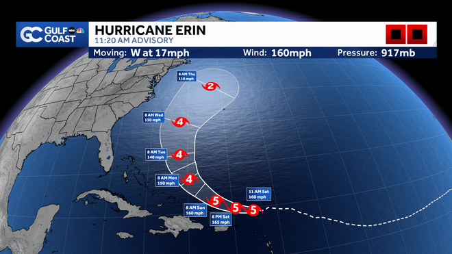
The Gulf Coast Hurricane Tracking team continues to monitor the movement of Hurricane Erin over the Atlantic Ocean. As of 11:30 a.m. Saturday, Erin’s wind strength has increased to 160 mph, making the storm a major category 5 hurricane. Erin has been rapidly intensifying this morning and has increased wind speeds by 85 mph over the last 18 hours. The latest pressure was noted at 917 mb and the storm’s forward motion is west at 17 mph. This is the first major hurricane in the Atlantic for this season.Hurricane Erin’s center is currently located 195 miles northeast of Anguilla. Hurricane Week: Stories of survival, science, and recovery on the Gulf CoastErin will continue on a west-northwest track through the first half of the weekend. As it moves, Erin is expected to continue to be a major hurricane as it tracks north of the Caribbean this weekend. The term major hurricane includes all storms that are at least category 3 intensity and stronger, whether they impact any areas of land or not. By Monday, the current forecast calls for Erin to downgrade to a category 4 hurricane and remain there through Wednesday as it turns northward. What The Models Say Forecast models remain in agreement that the storm will stay north of the Caribbean and turn north prior to reaching the Bahamas. This would allow Florida to avoid any direct impacts from the storm.Erin will produce dangerous seas in the Atlantic, however, as it parallels the east coast of Florida. Our models show wave heights up to 35 feet near the center of the storm, with 10-foot wave heights possible near the east coast of Florida next week.We will continue to track Erin closely and alert you of any changes in the forecast. Other Areas We’re WatchingAlong with Hurricane Erin, we are also monitoring an area of lower pressure off the coast of North Carolina. The National Hurricane Center says this area of disturbed weather has a small window of time this weekend to potentially show some signs of organization, but by early next week, the environment looks hostile for development. Regardless of development, the area of weather will have no impact on Southwest Florida. Hurricane WeekIsland Park neighbors concerned about flooding, Lee County working on solutionsMatlacha pushes forward as last storm-damaged buildings set for demolitionFort Myers resident installs flood barriers to protect home and car’Each tree and each site is going to be different’: Ways to prepare trees for hurricane seasonIs your home really hurricane-resistant? Inspector shares what to checkManasota Key bounces back from Hurricane Milton, prepares for future stormsParadise shaken, not broken: Manasota Key residents look back on Hurricane Milton’s tollThe Atlantic hurricane season runs from June 1 through Nov. 30. Follow Gulf Coast News online and on air for Southwest Florida’s Most Accurate weather forecast.Be prepared with the Gulf Coast News 2025 Hurricane GuideLive Interactive RadarCheck out the interactive Gulf Coast Live RadarWatch your Gulf Coast Weather forecasts on TV or onlineHere’s where to find our latest weather forecast videoYou can also watch newscasts live or on demand hereOr download the Gulf Coast News app to stream on your phone or tabletFollow the Gulf Coast Storm Team on social mediaChief Meteorologist Allyson Rae on Facebook and XMeteorologist Caroline Castora on Facebook and XMeteorologist Jim Dickey on Facebook and XMeteorologist Jason Dunning on Facebook and XMeteorologist Rob Duns on Facebook and XMeteorologist Lauren Hope on Facebook and XMeteorologist Raphael Tavernier on Facebook and XDOWNLOAD the free Gulf Coast News app for your latest breaking news and weather alerts. And check out the Very Local Gulf Coast app to stream news, entertainment and original programming on your TV.
FORT MYERS, Fla. —
The Gulf Coast Hurricane Tracking team continues to monitor the movement of Hurricane Erin over the Atlantic Ocean.
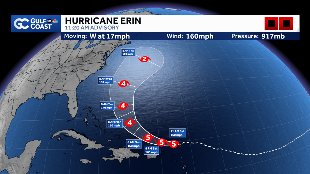
As of 11:30 a.m. Saturday, Erin’s wind strength has increased to 160 mph, making the storm a major category 5 hurricane. Erin has been rapidly intensifying this morning and has increased wind speeds by 85 mph over the last 18 hours. The latest pressure was noted at 917 mb and the storm’s forward motion is west at 17 mph. This is the first major hurricane in the Atlantic for this season.
Hurricane Erin’s center is currently located 195 miles northeast of Anguilla.

Gulf Coast News
Hurrican Erin rapidly intensifies into a cat 5 storm
Hurricane Week: Stories of survival, science, and recovery on the Gulf Coast
Erin will continue on a west-northwest track through the first half of the weekend.
As it moves, Erin is expected to continue to be a major hurricane as it tracks north of the Caribbean this weekend.
The term major hurricane includes all storms that are at least category 3 intensity and stronger, whether they impact any areas of land or not.
By Monday, the current forecast calls for Erin to downgrade to a category 4 hurricane and remain there through Wednesday as it turns northward.
What The Models Say
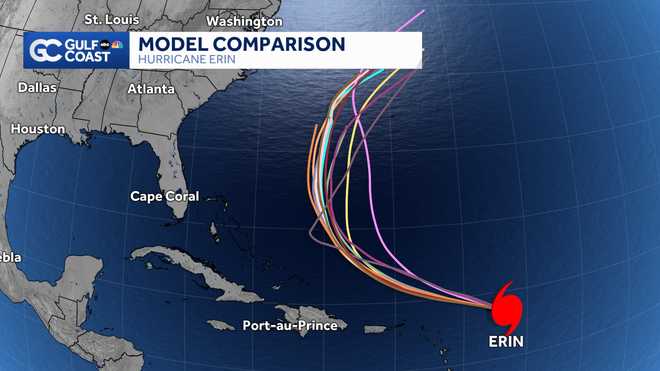
Forecast models remain in agreement that the storm will stay north of the Caribbean and turn north prior to reaching the Bahamas. This would allow Florida to avoid any direct impacts from the storm.

Gulf Coast New
Forecast model comparison
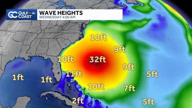
Erin will produce dangerous seas in the Atlantic, however, as it parallels the east coast of Florida. Our models show wave heights up to 35 feet near the center of the storm, with 10-foot wave heights possible near the east coast of Florida next week.

Gulf Coast News
Model Wave Heighs
We will continue to track Erin closely and alert you of any changes in the forecast.
Other Areas We’re Watching
Along with Hurricane Erin, we are also monitoring an area of lower pressure off the coast of North Carolina.
The National Hurricane Center says this area of disturbed weather has a small window of time this weekend to potentially show some signs of organization, but by early next week, the environment looks hostile for development.
Regardless of development, the area of weather will have no impact on Southwest Florida.
Hurricane Week
The Atlantic hurricane season runs from June 1 through Nov. 30. Follow Gulf Coast News online and on air for Southwest Florida’s Most Accurate weather forecast.
Live Interactive Radar
Watch your Gulf Coast Weather forecasts on TV or online
Follow the Gulf Coast Storm Team on social media
Chief Meteorologist Allyson Rae on Facebook and XMeteorologist Caroline Castora on Facebook and XMeteorologist Jim Dickey on Facebook and XMeteorologist Jason Dunning on Facebook and XMeteorologist Rob Duns on Facebook and XMeteorologist Lauren Hope on Facebook and XMeteorologist Raphael Tavernier on Facebook and X
DOWNLOAD the free Gulf Coast News app for your latest breaking news and weather alerts. And check out the Very Local Gulf Coast app to stream news, entertainment and original programming on your TV.

