
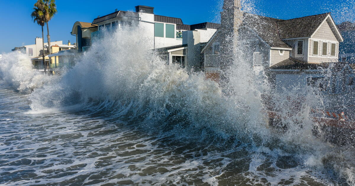
Coastal communities from Newport Beach to Long Beach were hit by significant flooding from large waves on Friday as Southern California braces for the arrival of Tropical Storm Rachel, which is expected to make landfall near the California- Mexico border early Sunday.
Rachel’s arrival brings the potential for strong winds, rain and more damaging coastal flooding. If the current storm trajectory continues, Rachel’s effects will be felt mostly in San Diego County. However, Orange and Los Angeles counties are still forecast to see widespread rain and isolated coastal flooding as a result of the system, according to the National Weather Service.
“Even though the center of Tropical Storm Rachel will be well south of Los Angeles County, the significant swell in the ocean coming initially from the south, and then also phasing with a swell from the west, will bring coastal flooding concerns from any time from now through Tuesday, peaking on Sunday,” said National Weather Service Meteorologist-in-Charge Ariel Cohen.
The National Weather Service office in San Diego on Friday issued a rare tropical storm watch for most of San Diego County, including areas like San Diego, Chula Vista, Carlsbad and Oceanside, meaning that tropical storm-force winds are possible somewhere in the area over the next 48 hours. It’s only the second time a tropical storm watch has been issued in California.
The incoming storm could damage porches, awnings, carports, sheds and unanchored mobile homes, and snap off large tree branches, posing a safety risk, the weather service office said. It warned of hazardous driving conditions on bridges and other elevated roadways.
Predictions that Rachel, currently spinning about 800 miles off the coast of San Diego, will actually strengthen as it approaches the West Coast is unusual and remarkable, said UC Agriculture and Natural Resources climate scientist Daniel Swain.
Typically, once storms enter the cooler water in the eastern tropical Pacific they weaken significantly. But a marine heat wave and El Niño conditions — bringing ocean temperatures 10 to 13 degrees higher than normal — have provided a more conducive environment for Rachel.
“It’s notable that this is an unusual event that’s being made possible by both coincidence of this early arriving low-pressure trough off the coast of California and the record warm — and I do mean record warm — ocean temperatures off the coast of California right now,” Swain said during a briefing Friday.
On Friday morning, Southern Californians got a preview of what’s to come with Rachel’s arrival.
Streets on the Balboa Peninsula in Newport Beach were flooded with at least a foot of water during high tide, with the police department advising residents and motorists to avoid the area. The flooding was remarkable even in a neighborhood that has been prone to regular water inundations in the past, particularly during El Niño.
“This is the worst I’ve seen it in my 20 years on the Peninsula,” said Councilman Joe Stapleton.
Water from a massive swell — double the size that was initially predicted — blasted through 20-foot berms erected at the Wedge and washed out roads from about 21st Street to 6th Street, officials said.
“This swell was very unprecedented coming up that high,” said Georgia Rios, a spokesperson for the city of Newport Beach. “We knew we were going to have a high swell due to Tropical Storm Rachel, but along with El Niño it really has been a combination force here in Newport.”
The city declared a local emergency Friday and urged residents to pick up sandbags to protect their homes over the weekend. City crews are pumping out water on the streets, rebuilding beach berms and opening tide valves to help mitigate water intrusion.
“This is not even the worst that is expected,” Rios said. “It’s forecast to get even worse on Sunday with rain.”
In Laguna Beach, Coast Highway and Broadway was inundated with water from big waves and high tide. The typically sandy sections of Main Beach — where locals often gather to walk along the sand and play beach volleyball — were transformed into a sea of water.
At San Onofre State Beach, the road that surfers and beachgoers use to access the iconic spot was damaged resulting in a myriad of parking issues. The beach has been undergone significant coastal erosion in recent years and advocates say it could be hit hard this winter.
Hurricane Isaias will not be the only tropical system affecting the U.S. in the coming days. Moisture from T.S. Rachel will create the potential for locally heavy rainfall and bring the risk of flash flooding Saturday-Monday from Southern California into Utah. pic.twitter.com/2n3dZ8qbHI
— NWS Weather Prediction Center (@NWSWPC) October 9, 2026
In Long Beach, which has been hit hard this season by a series of back-to-back distant hurricanes, powerful waves crumbled large sections of the boardwalk on the peninsula and left several homes with severe structural damage. Video showed waves slamming against the bulkhead that protects beachfront homes.
The city has already been besieged by an unusually active, El Niño-fueled hurricane season, taking damage from Hurricane Marie over Labor Day weekend and Hurricane Polo last month.
“We’ve had three storms back pretty much back to back to back,” said Laath Martin, a spokesperson for the city. “This is definitely not something that we see very often.”
Officials have red-tagged two properties, including a duplex with three units. Three buildings have also been yellow-tagged after sustaining damage from Hurricane Marie ahead of Rachel’s arrival.
Long Beach has already distributed more than 7,500 sandbags, as residents prepare for what could feel like a very long weekend.
“It’s hard to predict exactly what will happen, but just based on forecasts, we’re preparing for more damage,” Martin said.
Rain timing
Across Southern California, the highest chances of rain are between Sunday morning and Monday night, forecasters say. In Los Angeles County, rain is expected to be light to moderate, ranging from about a quarter of an inch to an inch across much of the region. A bit more rain is expected in the San Gabriel Mountains, according to the weather service office in Oxnard.
Rain rates are probably going to be a quarter of an inch per hour or less, making debris flow and landslides unlikely.
“There will be a couple thunderstorms out and about, especially later on Sunday. But we’re not looking at any long duration excessive rainfall,” Cohen said on Friday.
A bit more rain is expected in Orange and San Diego counties with coastal areas receiving half an inch to an inch over the weekend and into early next week. Higher elevations, including Big Bear and Julian, could get up to an inch and a half of precipitation.
While tropical moisture from the remnants of Rachel is expected to deliver only light rain to much of Southern California, the Mojave Desert and the Inland Empire could see more significant precipitation.
The weather service is warning that there is a moderate, or 40% chance, of excessive rainfall that could lead to flash flooding in places like San Diego, El Cajon, Chula Vista, Escondido, Palm Springs and Twentynine Palms. A moderate risk means that numerous flash floods are likely, and that many streams may flood. There is a potential that the San Diego River near Fashion Valley could reach minor flood stage.
There’s also a 15% chance of that occurring in Oceanside, San Clemente, Laguna Niguel, Riverside, San Bernardino, Las Vegas and the California-Arizona border; and a 5% chance in places like Huntington Beach, Santa Ana, Long Beach, Anaheim, Pomona, Victorville, Barstow, and most of Arizona and southern Utah.
Wind
The tropical storm watch in San Diego County means that there is a potential for winds of 39 mph to 57 mph. “Act now to complete preparations before the wind becomes hazardous,” the weather service said. “Prepare for limited wind damage.”
Other potential sources of damage could include shallow rooted trees that could snap or uproot, “especially in coastal and valley locations that don’t typically experience strong winds.”
The weather service also warned of hazardous seas off the San Diego County coast.
“Very strong winds will cause hazardous seas, which could capsize or damage vessels and reduce visibility,” the weather service said. “Tropical storm-force winds could begin as early as Saturday night but are most likely to occur during the day Sunday.”
Flooding risk
Coastal flooding will remain the biggest concern for the region in the coming days, particularly for south-facing shores including Long Beach, Malibu and Point Mugu. Swells will not only bring the potential for water intrusion, but also life threatening surf — ranging from 3 feet to 6 feet in some areas — and rip currents, according to the weather service.
Tides in Southern California are expected to be 1 foot to 1.5 feet above what would ordinarily be expected without the abnormally warm ocean temperatures wrought by El Niño. The high tides and surf, a Kelvin wave, and winds up to 40 mph could all contribute to coastal flooding, forecasters say, though it’s too soon to say how severe.
“Even though the main traditional tropical storm direct impacts will be well south of the Los Angeles area, folks from Long Beach, San Pedro, all the way up through Malibu, Zuma Beach area and Catalina Island, especially south to west-facing beaches, need to be aware that especially Sunday we will see an escalation in coastal flooding concerns, with the potential for some major damage in some areas,” Cohen said.
A coastal flood advisory for Ventura, Los Angeles, Orange and San Diego counties — warning of the potential for flooding in beach parking lots, boardwalks and roads, with isolated road closures expected, along with minor coastal erosion — is expected to remain in effect through Tuesday afternoon.
The tropical storm watch issued for San Diego County is only the second time in state history such a warning has been issued. The first was for Tropical Storm Hilary in 2023, which had degenerated into a post-tropical low by the time it reached California.
Hilary still brought record-breaking rain to the region, resulting in washed out streets, damaged homes and widespread power outages. It unleashed debris flows in San Bernardino County, flooded the Coachella Valley and damaged roads in Death Valley National Park.
This time around, the real problem will be coastal flooding, said Miguel Miller, a meteorologist with the weather service office in San Diego.
“We’ve got water that’s already high and then we’re going to have periods of high tides each morning and evening and then on top of that we have high surf,” he said. “We have all these things stacking up on each other and we’ve already seen in recent weeks how just the high tides, even without the large surf, is putting water into places where it doesn’t usually go.”
This comes as forecasters say odds are increasing that this El Niño will be the strongest in the modern record, which goes back 76 years.
El Nino update
On Thursday, the National Oceanic and Atmospheric Administration’s Climate Prediction Center said the chance of a historic, record-breaking El Niño is now 83%, up from the probability of 75% issued last month. The climate pattern typically emerges every two to seven years and is marked by the heating of ocean waters in the central and eastern equatorial Pacific, which spurs changes in the atmosphere that can affect weather around the world.
In Southern California, strong El Niños are generally associated with higher-than-average rainfall. Some of the strongest El Niño years, like in 1982-83 and 1997-98, left a swath of devastation across the state.
But not all of them turn out that way. The 2015-16 El Niño season didn’t deliver elevated rainfall, but resulted in record coastal erosion.
“From the big picture standpoint … all that warmth in the Pacific Ocean means there is a whole lot more energy available to convey to the atmosphere to create those storm systems that come along,” Michael Anderson, a state climatologist with the Department of Water Resources, said during a California Natural Resources Agency webinar on Thursday.
“There is all the energy we have ever seen available for these wintertime storms to make use of, and that’s why we want to pay attention,” he added.