
Published Oct. 22, 2026 5:00 a.m. GMT
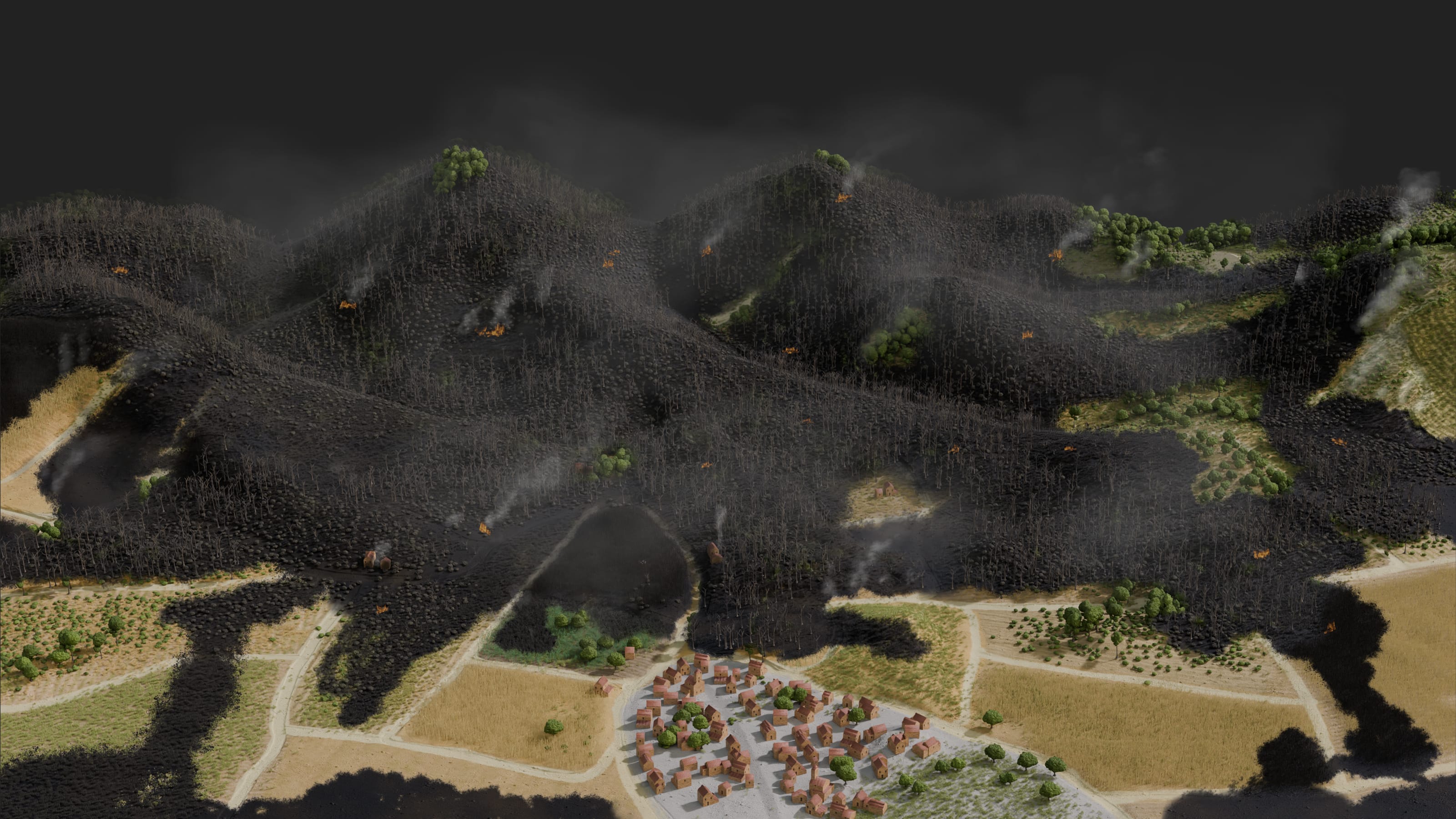
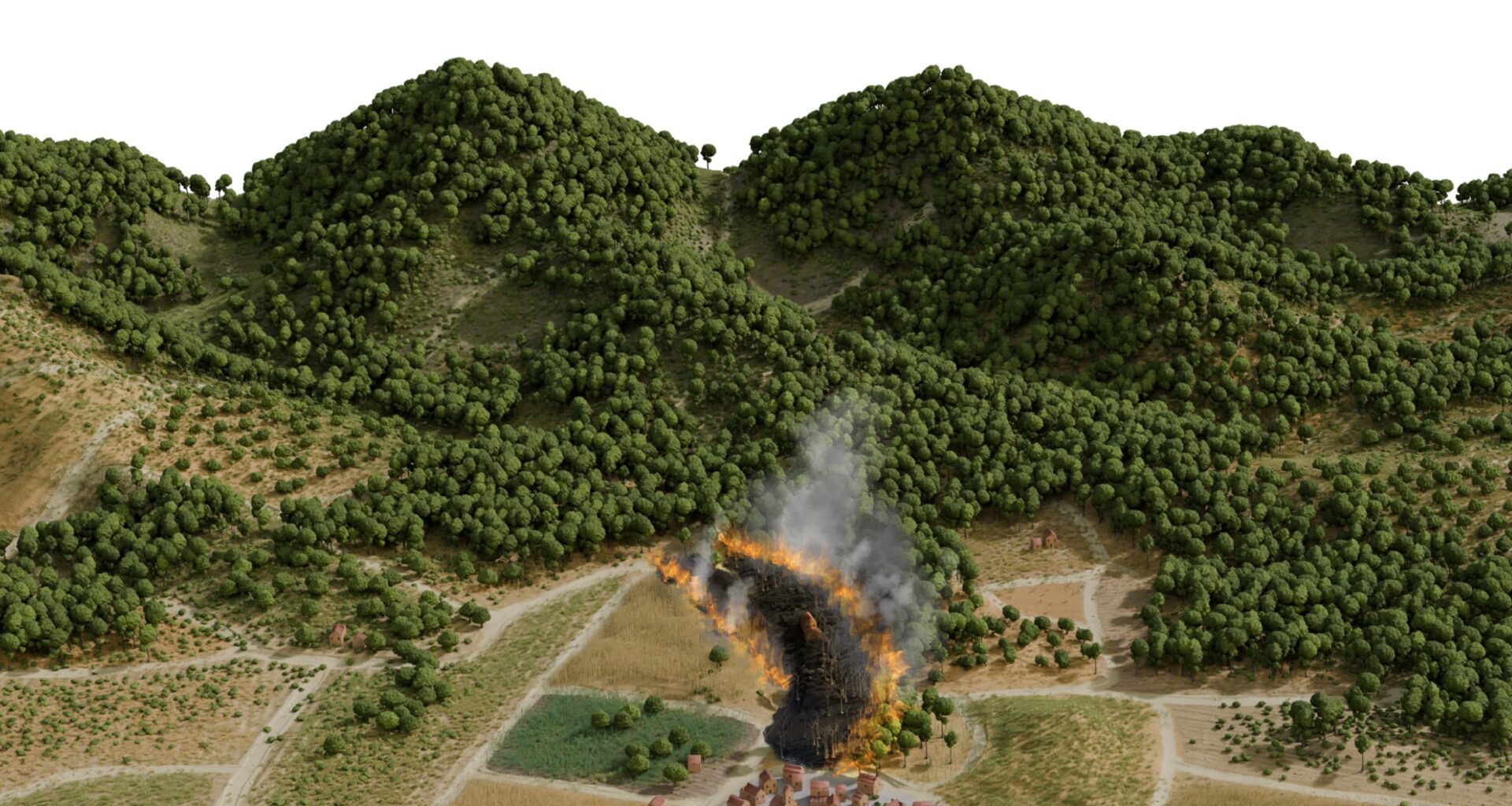
Crops Crops Crops Fire Trees Shrubs Young forest Fire
Europe is emerging from one of its worst wildfire seasons on record. Deadly blazes this year ripped through countries including Spain, France and Greece, forcing hundreds of thousands to evacuate and burning 699,000 hectares (1.7 million acres) – an area more than four times the size of London.
The disasters highlighted how climate change is fuelling hot and dry conditions that amplify wildfires. But another, often-overlooked factor played a pivotal role in some instances: How governments and private landowners are managing Europe’s emptying countryside.
In the 1950s, the countryside west of Madrid, Spain’s capital, was a mosaic of crop fields and pastures, intersected by rural roads. If a fire ignited, the fragmented landscape would limit its spread, half a dozen experts told Reuters.
By 1975, the first signs of declining rural activity were visible in aerial photographs: shrubs and trees were starting to take over abandoned farmland, building up vegetation in the landscape.
In the decades that followed, young forests took root. The woodland spread across old parcel boundaries, growing denser and joining together to form more continuous forest.
Now, if a fire starts, the continuous vegetation provides fuel for the flames to spread. If another breaks out nearby, the two can quickly merge into a vast blaze that overwhelms firefighters.
As climate change pushes temperatures to new peaks, the consequences of this landscape evolution are becoming clear: This summer, tinder-dry stretches of untended forest and shrubland served as the perfect fuel for Spain’s biggest wildfire in recent history.
It began on July 22, when sparks from heavy machinery ignited a fire near Burgohondo, a mountain village about 90 km (56 miles) west of Madrid, in the central province of Avila, according to Spain’s Civil Guard police force. Propelled by strong winds, the fire spread fast and far, prompting the evacuation of more than 60,000 people.
By July 26, it had merged with two other fires that started near the towns of Almorox, in Toledo province, and San Martin de Valdeiglesias, in the Madrid region. By the time the last hotspots were extinguished on October 3, the blaze had consumed 63,000 hectares, according to regional tallies, destroying homes, restaurants, sports facilities and farms.
Satellite fire detections
Fire origin
Burgohondo
ÁVILA
San Martín de
Valdeiglesias
MADRID
Satellite fire detections
Fire origin
Burgohondo
ÁVILA
San Martín de
Valdeiglesias
MADRID
Satellite fire detections
Fire origin
Burgohondo
ÁVILA
San Martín de
Valdeiglesias
MADRID
Source: Active fire detections are from NASA’s Fire Information for Resource Management System (FIRMS), using Visible Infrared Imaging Radiometer Suite (VIIRS) observations. Points indicate thermal anomalies associated with active fires.
It was one of dozens of large wildfires in Spain this summer. More than 300,000 hectares were burned in all, according to the European Forest Fire Information System (EFFIS). That is roughly three times the country’s average annual burn area over the past two decades.
At least 21 people died, making 2026 one of Spain’s deadliest wildfire seasons in decades.
A wildfire spreads over the Burgohondo mountains in Spain’s Avila province on July 23, 2026. REUTERS/Ana Beltran
Flames rise above the forest near the town of San Martin de Valdeiglesias in the Madrid region on July 26, 2026. REUTERS/Ana Beltran
The charred remains of a deer lie in the forest near the small Avila town of El Tiemblo on July 28, 2026. REUTERS/Umit Bektas
Reuters analysed aerial and satellite imagery in the area affected by the megafire, reviewed land cover inventories and ownership records, and interviewed more than a dozen wildfire experts, forestry officials and landowners to understand how changes to the landscape and the way it is managed increase Spain’s vulnerability.
The people who spoke to the news agency all said land maintenance and fire prevention efforts in the country’s expanding forests fall short of what is needed in today’s hotter climate.
Fire perimeter
July 22-31, 2026
Fire perimeter
July 22-31, 2026
Fire perimeter
July 22-31, 2026
Secondary annotation @14px
Tertiary annotation @12px
Locator map showing the wildfire perimeter west of Madrid and the area enlarged in the aerial and satellite image comparison below.
Before-and-after comparison of aerial imagery from 1956–57 and satellite imagery from 2026, showing how a patchwork of farmland west of Madrid has become more continuous woodland.
Sources: The 1956–57 orthophoto is from the Spanish National Geographic Institute (American Flight, 1956–57). The 2026 satellite image is from Google Maps.
A changing landscape
In the second half of the 20th century, millions of people moved out of Spain’s countryside, an exodus spurred by the mechanisation of farming and new employment opportunities in rapidly industrialising cities and towns.
In 1960, about 56% of Spaniards lived in urban areas, World Bank data shows. By 2024, that had risen to 80%. Over time, the rural landscapes people left behind became neglected and overgrown with vegetation.
Spain’s forest cover increased 38% between 1990 and 2025, to 19.1 million hectares, United Nations-compiled data shows, a trend driven in part by European Union-backed schemes to plant trees on former farmland.
In 2005, Spain’s woodland exceeded its agricultural land.
In 2005, Spain’s woodland exceeded its agricultural land.
In 2005, Spain’s woodland exceeded its agricultural land.
Chart showing changes in Spain’s agricultural land, scrubland and woodland from 1860 to 2009, with woodland overtaking agricultural land in 2005.
Note: Some historical figures are estimates. Points show available data.
Source: Spanish Society of Forest Sciences (SECF), Report on the State of Forests and the Forest Sector in Spain (2010).
Inside the perimeter of the July megafire, forest cover increased 54% between 1990 and 2018, to 35,000 hectares, the Reuters analysis found. That’s 12,000 additional hectares of pines, oaks and other vegetation added to the landscape in less than three decades.
Between 1990 and 2018, the area classified as forest within the fire
perimeter increased by 54.1%.
Between 1990 and 2018, the area classified as forest within the fire
perimeter increased by 54.1%.
Between 1990 and 2018, the area classified as forest within the fire
perimeter increased by 54.1%.
Between 1990 and 2018, the area classified as forest within the fire
perimeter increased by 54.1%.
Between 1990 and 2018, the area classified as forest within the fire
perimeter increased by 54.1%.
Map comparing CORINE Land Cover data from 1990 and 2018, highlighting areas classified as forest in 2018 that were other land cover types in 1990.
Note: The map compares CORINE Land Cover inventories for 1990 and 2018, the latest available in the series. Forests include broad-leaved, coniferous and mixed forests. “New forest” refers to land classified as forest in 2018 that was listed in other land-cover categories in 1990, mainly shrubland and transitional woodland.
Source: Copernicus Land Monitoring Service’s CORINE Land Cover dataset (1990, 2018)
Land-cover inventories compiled by the European Environment Agency’s Copernicus Land Monitoring Service show how farmland transitioned to shrubland and woodland inside the burn zone between 1990 and 2018, the most recent year for which data is available.
Of the area mapped as forest in 2018 within the fire perimeter, 34.9% was classified as shrubland or transitional woodland in 1990, and 5.7% agricultural land.
Of the area mapped as forest in 2018 within the fire perimeter, 34.9% was classified as shrubland or transitional woodland in 1990, and 5.7% agricultural land.
Of the area mapped as forest in 2018 within the fire perimeter, 34.9% was classified as shrubland or transitional woodland in 1990, and 5.7% agricultural land.
Of the area mapped as forest in 2018 within the fire perimeter, 34.9% was classified as shrubland or transitional woodland in 1990, and 5.7% agricultural land.
Of the area mapped as forest in 2018 within the fire perimeter, 34.9% was classified as shrubland or transitional woodland in 1990, and 5.7% agricultural land.
Sankey diagram showing how land cover changed between 1990 and 2018, highlighting which land cover types became woodland and contributed to the new forest area.
Note: CORINE Land Cover is a European inventory of land cover and land use with more than 40 categories. Reuters consolidated detailed classifications into five broad groups — forest, shrubland and transitional woodland, agricultural land, natural grassland and other land cover — to track how areas changed classification between the 1990 and 2018 maps.
Source: Copernicus Land Monitoring Service’s CORINE Land Cover dataset (1990, 2018)
Similar shifts have been taking place across Spain and in other Mediterranean countries, where wildfire risk is high. Europe’s forest cover increased 11% between 1990 and 2025, to 232 million hectares, the UN-compiled data shows.
Alex Held, a wildfire expert at the European Forest Institute, said there was less vegetation to fuel blazes in parts of Spain, Portugal, Italy and Greece, when more land was used for farming, grazing animals and firewood collection. Now, many areas have become overgrown, Held said, “and very often this recolonisation is with very flammable vegetation.”
The growing risk to lives and property
If these new forests aren’t managed, it can create conditions for fires to burn out of control, said Victor Resco de Dios, a professor of forest science at Spain’s University of Lleida.
Wet winter weather in Spain fuelled explosive growth in vegetation this year, much of which dried out over the summer due to record-breaking temperatures and drought. In areas where dead wood and dry undergrowth weren’t cleared away, fires built to an intensity far beyond what firefighters can manage, Resco de Dios said.
Flames can climb a fire ladder of grass, shrubs and low branches
into the treetops. When this happens, firefighters say they can become
impossible to control.
Reducing undergrowth through controlled burns, brush clearing and animal
grazing breaks the ladder and reduces the chance that fires
will get into the treetops, making them easier to fight.
Diagram showing how grass, shrubs and lower branches form a fuel ladder that allows fire to reach treetops, and how clearing undergrowth and livestock grazing can break this connection.
Expanding forests are bringing wildfire risks closer to where people live. The July blaze reached to within 35 km of Madrid – the first time the city has been threatened by a wildfire of this magnitude, officials said.
Watching through security cameras installed at his home, Cesar Gallardo saw flames sweeping through his garden and damaging the windows of his house in the small Avila town of El Tiemblo. When he returned the next day, the forest around him was scorched black.
He counted himself lucky not to have sustained more losses.
“Practically everything was burning,” Gallardo, 41, told Reuters TV in July.
Why fire prevention falls short
Regional governments have primary responsibility for fire prevention and response in Spain. The national government deploys resources to support them as needed, including aircraft and ground units to fight large wildfires.
Authorities in the Castilla y Leon region, which includes Avila, said they budgeted €16 million ($17.94 million) for recent or ongoing forest management and fire prevention efforts on public land in the area hit by the fire. They include initiatives to remove dry vegetation, thin trees and maintain forest tracks and defensible lines called firebreaks.
But much of the forest in Avila – about 68% – is on private land, where responsibility for this kind of maintenance rests with the owner, government data shows. That includes most of the forested land closest to villages and towns like El Tiemblo, Reuters found.
Satellite imagery and property records show the forest near El Tiemblo has advanced over a kilometer since 1957, spreading from public land into hundreds of small, private plots once used to grow olive trees, vineyards, vegetables and grains.
In July, the fire reached El Tiemblo’s edge, where dense forest had spread to
within 200 metres of the town.
Much of the forest land closest to towns such as El Tiemblo lies on private parcels that may belong to different owners.
In July, the fire reached El Tiemblo’s edge, where dense forest had spread to
within 200 metres of the town.
Much of the forest land closest to towns such as El Tiemblo lies on private parcels that may belong to different owners.
In July, the fire reached El Tiemblo’s edge, where dense forest had spread to
within 200 metres of the town.
Much of the forested land closest to El Tiemblo lies on private parcels that may belong to different owners.
Much of the forested land closest to El Tiemblo lies on private parcels that may belong to different owners.
In July, the fire reached El Tiemblo’s edge, where dense forest had spread to
within 200 metres of the town.
This fragmentation can make it harder to coordinate vegetation clearance
and other fire-prevention measures.
Secondary annotation @14px
Tertiary annotation @12px
Map showing public and private forests alongside newly wooded areas, illustrating how fragmented private land ownership complicates firefighters’ work where woodland has expanded.
Note: White lines show the boundaries of individual plots of land, as recorded in Spanish property records. Forested land also includes some shrubland and other non-wooded areas.
Sources: Spanish property records from El Catastro Inmobiliario; Spain’s Ministry for Ecological Transition and the Demographic Challenge (MITECO); Regional Government of Castilla y Leon. Bing Maps.
Over 90% of the region’s more than 700,000 landowners have tiny plots of less than 1 hectare.
That complicates efforts to reduce fire risk, said Olga Gonzalez, managing director of the Federation of Forestry Associations of Castilla y Leon, which represents private owners. Some owners can’t afford to do costly maintenance work, and joining forces with neighbours can be a challenge when they don’t know who holds the derelict plot next door.
The regional government subsidises some fire prevention work on private land but only if it covers at least 25 hectares, a requirement aimed at ensuring the work is effective.
“In the end, forest management is not done because it is not economically profitable,” Gonzalez said.
Her federation is pushing for tax incentives and compensation for small landowners. It is also trying to organise them into groups to jointly manage their plots, to share costs and benefit from existing subsidies.
Stronger legal requirements for landowners to do prevention work could also help if backed by funding, said Victor Fernandez-Garcia, an assistant professor in pyrogeography, the study of wildfires, at Spain’s University of Leon.
Jorge Nieto, a park ranger who helped manage Castilla y Leon’s response to the Avila fire, said controlled burns to reduce the fuel load ahead of the fire season are underutilised there, in part because they are unpopular with locals. While there are firebreaks in some areas, he said, many were no match for July’s blaze. The fire jumped them.
How wildfires jump firebreaks
Flames can reach two to three times the height of burning vegetation.
Wind can carry burning bark, pine cones and embers across firebreaks, starting new
fires beyond them.
15 metres
Minimum firebreak width
in wooded areas in Spain
How wildfires jump firebreaks
Flames can reach two to three times the height of burning vegetation.
Wind can carry burning bark, pine cones and embers across firebreaks, starting new
fires beyond them.
15 metres
Minimum firebreak width in wooded areas in Spain
How wildfires jump firebreaks
Flames can reach two to three times the height of burning vegetation.
Wind can carry burning bark, pine cones and embers across firebreaks, starting new
fires beyond them.
15 metres
Minimum firebreak width in wooded areas in Spain
How wildfires jump firebreaks
Flames can reach two to three times the height of burning vegetation.
Wind can carry burning bark, pine cones and embers across firebreaks, starting new
fires beyond them.
15 metres
Minimum firebreak width in wooded areas in Spain
How wildfires jump firebreaks
Flames can reach two to three times the height of burning vegetation.
Wind can carry burning bark, pine cones and embers across firebreaks, starting new
fires beyond them.
15 metres
Minimum firebreak width in wooded areas in Spain
Diagram showing how wildfires can cross firebreaks as wind carries burning bark, pine cones and embers beyond the cleared strip, igniting new fires on the other side.
Source: Flame length estimate: Ferran Dalmau, a forest engineer who was part of a specialised team deployed by Spain’s environment ministry to respond to the Avila fire. Firebreak minimum width: Spain’s Ministry for Ecological Transition and the Demographic Challenge (MITECO).
Many firebreaks aren’t maintained as often as they should be, Nieto said. “It’s a question of funding.”
The available data indicates that Spain’s regions budgeted at least €1.8 billion for wildfire prevention and suppression in 2025, according to an analysis by economists Maria-Luisa Chas-Amil and Emilio Nogueira-Moure from the University of Santiago de Compostela. But the vast majority – 78% – was for firefighting, they wrote in a July article published in the Conversation, which carries commentary by academics.
Investing more in prevention could save money in the long run, said Steven King, senior vice president at Resource Management Service, which manages forestry investments around the world. “We can’t control the weather, but we can control the fuel load.”
Spain’s environment secretary, Hugo Moran, denied the country prioritises wildfire suppression over prevention, saying the figures cited in the recent article are far from complete. So did regional authorities in Castilla y Leon and Castilla-La Mancha, which includes Toledo.
Castilla-La Mancha’s sustainable development department said about 60% of its wildfire spending goes toward fire prevention, including tree pruning, brush removal and other measures around built-up areas — measures that helped avoid any damage to homes during the July fire. The two other regions did not provide breakdowns of their spending.
Moran and some regional officials said lessons learned from the recent fires are being incorporated into local and national land-use plans. Measures are planned to promote the restoration of mosaic-like landscapes, create buffer zones around settlements and roads, and help small landowners do more fire prevention work.
But Moran said a more coordinated response is needed, given the growing risks posed by climate change.
“Fire knows no boundaries,” he said.
Mariano Zafra and Pietro Lombardi in Madrid and Kate Abnett in Brussels
Alexandra Zavis and Jon McClure