Hurricane Erin impacts begin along coast: Here’s the latest track and timing of impacts
All eyes on air and as it’s finally making its northerly turn. However, it’s growing in size. Let me show you what I’m talking about. That new track shows the storm system moving toward the north. Thankfully, drier air is getting on the west side, which is going to keep it at its same strength or near it. Though the core is going to stay just offshore because the system is getting wider, the outer banks are going to have some high impacts, not to mention the rip currents. Be up and down from Florida to the Carolinas through the mid-Atlantic. Simply put, just don’t get in the water through the rest of the week. It is just too, too dangerous. Let me show you this. I mean, folks, it’s worth counting our blessings here because if we would have had *** direct landfall with this system, it is *** monster storm moving toward the north right here. The worst of the storms could be just offshore, but those wind impacts are going to be expanded. And because of that, Almost *** 500 mile wide storm here is going to send *** lot of water into the Outer Banks right here, which is why they’ve evacuated. 2025 ft waves on top of that moving toward the north and east. It’s going to be *** very windy, rough surf day on Thursday. Wednesday and Thursday are the roughest of the days with this system. The good news I have for you, because this system is so strong, it’s upwelling, bringing up colder. Water from the bottom of the Atlantic. What that’s doing is making not so great of an environment for this secondary system. The models are really, really pushing down the chance that that’s going to develop into much of any concern for the United States. But back toward the east, we do have an invest. The models do show that will likely become *** tropical storm in the coming days, so *** lot to unpack as you watch Aaron getting out of the way and then map out those other two.
Hurricane Erin impacts begin along coast: Here’s the latest track and timing of impacts

Updated: 6:23 PM EDT Aug 19, 2025
Hurricane Erin is now a Category 2, but the storm continues to grow in size. While dry air and wind shear on its west side are keeping it from strengthening further right now, its expanding wind field means the storm’s impacts will spread wider. Dangerous rip currents have already led to water rescues along parts of the coast, and conditions will only worsen heading into midweek.Hurricane Stats:The track is now looking more locked in. As of Tuesday afternoon, Erin began its expected turn to the north, keeping the core “just offshore” of the East Coast rather than continuing its westward nudge. That’s good news, but the margin for error remains small — every mile matters.Hurricane Track:South Carolina Impacts Rip Currents & Surf: The biggest hazard continues to be rip currents, which are already proving dangerous. Swells and surf will build Tuesday into Wednesday and Thursday with waves of 5–7 feet possible along the coast. Rain/Wind: Direct wind and rain impacts remain limited unless Erin jogs west, but feeder bands could spark scattered storms. Spaghetti Models: North Carolina Impacts Outer Banks: This remains the area most at risk for direct impacts. If the track holds just offshore, winds of 60–70 mph are likely Wednesday night into Thursday. Coastal Flooding: Waves could reach 20–25 feet along the Outer Banks, leading to overwash and flooding of vulnerable coastal roads. Mandatory evacuations are already underway. Inland NC: Rainfall amounts remain limited and little to no wind impacts.Timing Tuesday: Storm is turning north, surf already building, rip currents high. Wednesday–Thursday: Peak impact window. Strongest winds, highest waves, and worst flooding risk for the Outer Banks. Friday onward: Erin accelerates northeast, pulling impacts away from the Southeast.
GREENVILLE, S.C. —
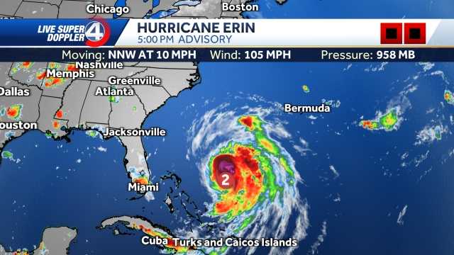
Hurricane Erin is now a Category 2, but the storm continues to grow in size.
While dry air and wind shear on its west side are keeping it from strengthening further right now, its expanding wind field means the storm’s impacts will spread wider.
Dangerous rip currents have already led to water rescues along parts of the coast, and conditions will only worsen heading into midweek.
Hurricane Stats:

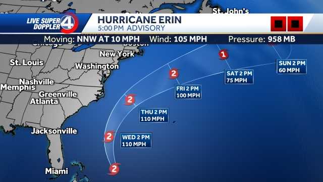
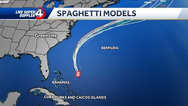
The track is now looking more locked in. As of Tuesday afternoon, Erin began its expected turn to the north, keeping the core “just offshore” of the East Coast rather than continuing its westward nudge. That’s good news, but the margin for error remains small — every mile matters.
Hurricane Track:

South Carolina Impacts
Rip Currents & Surf: The biggest hazard continues to be rip currents, which are already proving dangerous. Swells and surf will build Tuesday into Wednesday and Thursday with waves of 5–7 feet possible along the coast. Rain/Wind: Direct wind and rain impacts remain limited unless Erin jogs west, but feeder bands could spark scattered storms.
Spaghetti Models:

North Carolina Impacts
Outer Banks: This remains the area most at risk for direct impacts. If the track holds just offshore, winds of 60–70 mph are likely Wednesday night into Thursday. Coastal Flooding: Waves could reach 20–25 feet along the Outer Banks, leading to overwash and flooding of vulnerable coastal roads. Mandatory evacuations are already underway. Inland NC: Rainfall amounts remain limited and little to no wind impacts.
Timing
Tuesday: Storm is turning north, surf already building, rip currents high. Wednesday–Thursday: Peak impact window. Strongest winds, highest waves, and worst flooding risk for the Outer Banks. Friday onward: Erin accelerates northeast, pulling impacts away from the Southeast.

