Hurricane Erin nears Outer Banks: Here’s the latest track and timing of impacts
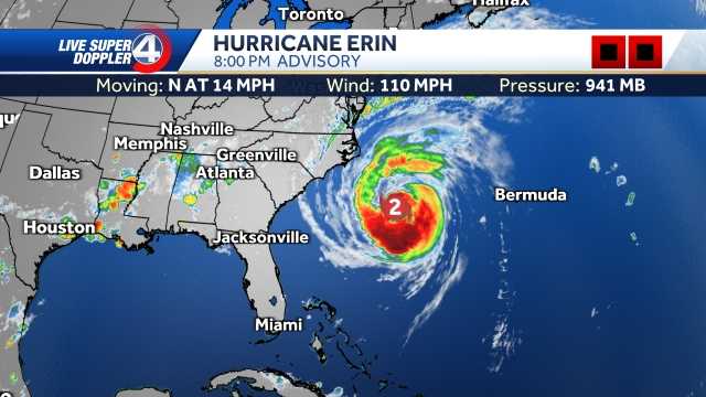
Hurricane Arin getting stronger. It is also getting larger. Let me show you what it’s doing right now just off the Carolina and Georgia coast as it moves toward the north. Winds are sustained at 110 MPH. This thing has gone through another eyewall replacement cycle, which means that inner eye wall is getting very, very strong, approaching *** Category 3 as we speak. Now, as it moves toward the north, the conditions are going to continue to go downhill for, uh, parts of the Outer Banks as this does. Back to CAT 3 status 120 MPH as it’s just offshore. That powerful push of water is going to cover *** lot of the Outer Banks underwater, and we’re going to get those waves on top of that as well. Now this begins to pull away. Look at the latest high resolution model. Some of those inner bands trying to get very close to the Outer Banks. Most of the eastern seaboard will be dry. It’s just the water is what’s going to be so dangerous as this powerful storm continues to move. toward the north and east and impacting all the way up toward the mid-Atlantic, even the Northeast seeing some impacts with this system. And look at the wind field. It is expanding. This is *** very wide storm that expands almost 550 miles wide. That’s why this storm, even though it’s not going to make landfall, it’s going to have some big impacts. Let’s bring in meteor meteorologist Grace Lau. She’s got some impacts here on the coast because these waves are so big. And that’s been what we’ve been talking about. I know since early last. Right? The wave height, something that’s caught my eye already. Take *** look at this. Within the eyewall, we’re looking at wave heights up to 50 ft. That’s taller than buildings. Now, that impact is being felt right along the North Carolina coast, the Outer Banks as well, up into, uh, Virginia Beach, and we’re seeing not only 6 to 8, but potentially 10 to 12 ft breakers out there. So the wave heights on top of onshore winds, right, pushing that water on. To the shore, which means we could see those issues, especially with life threatening rip currents on top of that large swell we just talked about that and storm surge. This is why parts of North Carolina, of course, are watching this storm as it makes its way up the coast. Dangerous boating conditions as well. So impacts really hasn’t changed that much since I know earlier this morning. However, impacts were beginning to see those now right along the Carolina coast.
Hurricane Erin nears Outer Banks: Here’s the latest track and timing of impacts

Updated: 8:08 PM EDT Aug 20, 2025
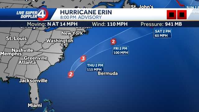
Erin is expected to re-intensify into a major hurricane as it draws closer to the coast. As of Wednesday, the hurricane is still a Category 2, but it is intensifying as a new eye wall has developed and the storms are better organized. The latest track keeps it “just offshore” of the East Coast, but shows the storm return to Cat. 3 status in the overnight hours.South Carolina Impacts:Rip Currents & Surf: The biggest hazard continues to be rip currents, which are already proving dangerous. Swells and surf will build through tonight and Thursday with waves of 5–7 feet possible along the coast.Rain/Wind: Direct wind and rain impacts remain limited unless Erin jogs west, but feeder bands could spark scattered storms.North Carolina Impacts:Outer Banks: This remains the area most at risk for direct impacts. If the track holds just offshore, winds of 60–70 mph are likely tonight into Thursday.Coastal Flooding: Waves could reach 20–25 feet along the Outer Banks, leading to overwash and flooding of vulnerable coastal roads. Mandatory evacuations are already underway.Inland NC: Rainfall amount remain limited and little to no wind impacts.Timing:Wednesday–Thursday: Peak impact window. Strongest winds, highest waves, and worst flooding risk for the Outer Banks.Friday onward: Erin accelerates northeast, pulling impacts away from the Southeast.Hurricane Stats:Hurricane Track:Spaghetti Models:A Storm Surge Warning is in effect for Cape Lookout to Duck, North Carolina.A Tropical Storm Warning is in effect for Beaufort Inlet, North Carolina to VA/NC state line. Life-threatening rip currents continue to be an issue for much of the East Coast. These dangerous conditions have already led to water rescues along parts of the coast, and conditions will only worsen as the storm moves in closer.
Erin is expected to re-intensify into a major hurricane as it draws closer to the coast.
As of Wednesday, the hurricane is still a Category 2, but it is intensifying as a new eye wall has developed and the storms are better organized. The latest track keeps it “just offshore” of the East Coast, but shows the storm return to Cat. 3 status in the overnight hours.
South Carolina Impacts:
Rip Currents & Surf: The biggest hazard continues to be rip currents, which are already proving dangerous. Swells and surf will build through tonight and Thursday with waves of 5–7 feet possible along the coast.Rain/Wind: Direct wind and rain impacts remain limited unless Erin jogs west, but feeder bands could spark scattered storms.
North Carolina Impacts:
Outer Banks: This remains the area most at risk for direct impacts. If the track holds just offshore, winds of 60–70 mph are likely tonight into Thursday.Coastal Flooding: Waves could reach 20–25 feet along the Outer Banks, leading to overwash and flooding of vulnerable coastal roads. Mandatory evacuations are already underway.Inland NC: Rainfall amount remain limited and little to no wind impacts.
Timing:
Wednesday–Thursday: Peak impact window. Strongest winds, highest waves, and worst flooding risk for the Outer Banks.Friday onward: Erin accelerates northeast, pulling impacts away from the Southeast.
Hurricane Stats:

Hurricane Track:

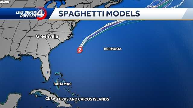
Spaghetti Models:

A Storm Surge Warning is in effect for Cape Lookout to Duck, North Carolina.
A Tropical Storm Warning is in effect for Beaufort Inlet, North Carolina to VA/NC state line.
Life-threatening rip currents continue to be an issue for much of the East Coast. These dangerous conditions have already led to water rescues along parts of the coast, and conditions will only worsen as the storm moves in closer.

