
Hurricane Kiko’s course has shifted and the major storm is now headed straight for Hawaii in a rare weather event for the islands.
New spaghetti models of the Category 2 hurricane project that the storm will strike Hawaii’s Big Island by next week.
Kiko has been building in strength in the eastern Pacific Ocean, with local meteorologists now predicting it will become major Category 3 hurricane Wednesday.
The storm has sustained winds of more than 100 mph after reaching hurricane status early Tuesday morning.
The last major hurricane to directly strike Hawaii was Hurricane Iniki in September 1992.
It struck as a Category 4 hurricane with sustained winds of 145 mph on September 11, resulting in six deaths, destroying over 1,400 homes, and causing an estimated $3 billion in damage.
As forecasters in Hawaii feared, Kiko’s path appears to have shifted slightly to the right, taking it towards the US islands and away from turbulent air that would have broken up the hurricane’s structure.
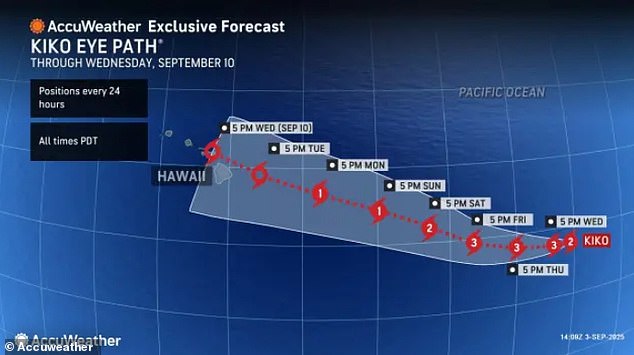
AccuWeather meteorologists agreed with the new spaghetti models, projecting that Kiko will make landfall in Hawaii at night on Tuesday, September 9.
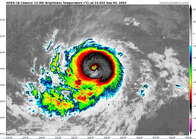
Hurricane Kiko entered Wednesday as a Category 2 storm with sustained winds of more than 100 mph
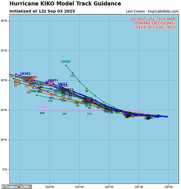
New prediction models for Hurricane Kiko warn that the storm may make a direct hit on Hawaii’s Big Island in the coming days
Up to eight inches of rain could pound the eastern side of the Big Island (Hawaii Island) once the storm hits, with around two inches predicted for the rest of the state next week.
Officials in Hawaii have not issued any hurricane warnings or alerts as of Wednesday morning.
The weather team from Hawaii News Now noted that it’s still too early to say for sure if the hurricane will make landfall on the Big Island, but the number of models projecting a direct hit have been growing.
A spaghetti model shows the different possible paths a tropical storm or hurricane might take, based on predictions from multiple weather computer programs.
Each line represents one model’s guess about where the storm could go. If the lines are close together, it means most models agree on the path, and the prediction is more certain.
Forecasters at NHC have projected that Kiko will continue to strengthen, churning into a major hurricane, until Saturday.
At that point, meteorologists expect the hurricane to weaken as it moves into cooler waters closer to Hawaii and encounters more wind shear.
That means Kiko is expected to run into stronger winds blowing at different heights in the atmosphere which can tear apart a hurricane’s structure.
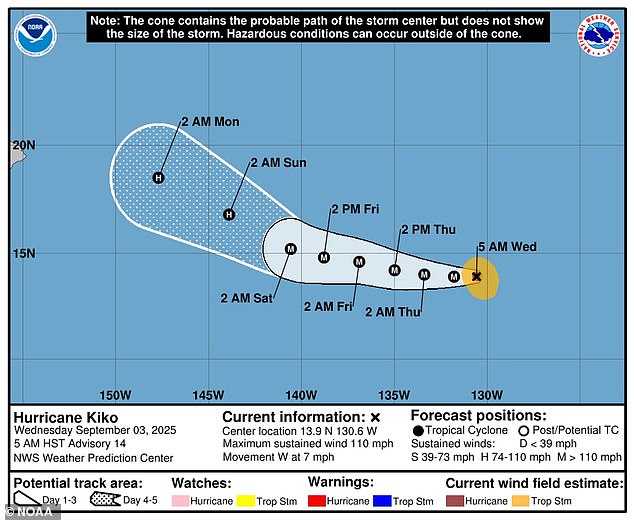
The National Hurricane Center has revealed that Hurricane Kiko’s path has shifted, putting it on a course for the Hawaiian Islands next week
The last major hurricane above Category 3 to directly strike Hawaii was Hurricane Iniki in 1992
Kiko is already the 11th named system in the eastern Pacific this year, and the Pacific hurricane season still has three months left to go.
The season runs from May 15 until November 30, making it two weeks longer than the Atlantic hurricane season.
Previously, the National Oceanic and Atmospheric Administration (NOAA) had predicted a ‘below-normal season’ for the eastern Pacific, with 12 to 18 named storms, five to 10 hurricanes, and up to five major hurricanes.
Another Pacific hurricane formed early Wednesday morning, Lorena, which is swirling off the coast of Mexico and could threaten states like Arizona and New Mexico this weekend.
On the other side of the US, NOAA projected an ‘above average’ season in the Atlantic which would likely more named storms than there were in 2024.
Overall, NOAA predicted up to 19 named storms, 10 hurricanes, and five major hurricanes affecting the US in 2025 .
NHC forecasters have been tracking the latest disturbance headed toward the East Coast, which now has a 70 percent chance of becoming a tropical depression by the end of the week, setting up the potential for the next named storm, Gabrielle.