
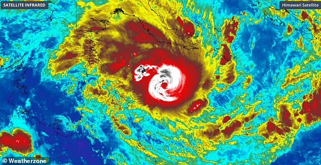
One of the most powerful cyclones in recent history has slightly weakened to a category four system but conditions remain just as dangerous as it bears down on Australia’s coastline.
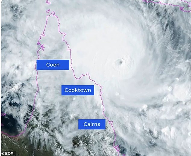
Residents are urged to take immediate shelter as Tropical Cyclone Narelle brings destructive winds of more than 270km/h near its centre when it crosses Queensland‘s Cape York Peninsula on Friday morning.
After intensifying in the Coral Sea to a peak category five system on Thursday, the Bureau of Meteorology confirmed the system had been downgraded early Friday, but warned conditions remained dangerous.
The monster storm was expected to make landfall about 7am on Friday near the remote community of Coen, north of Cairns, triggering downpours and ferocious winds that could ‘blow apart sheds’.
Emergency alerts have been issued urging residents in the remote communities of Lockhart River, Coen, and Port Stewart to take immediate shelter.
‘Take shelter now in the strongest part of the building you are in,’ the warning said.
Meteorologist Angus Hines said on Thursday afternoon that Narelle was an extremely powerful weather system.
‘They do not get more powerful than this.’
Cyclone Narelle has slightly weakened to a category four but conditions remain just as dangerous
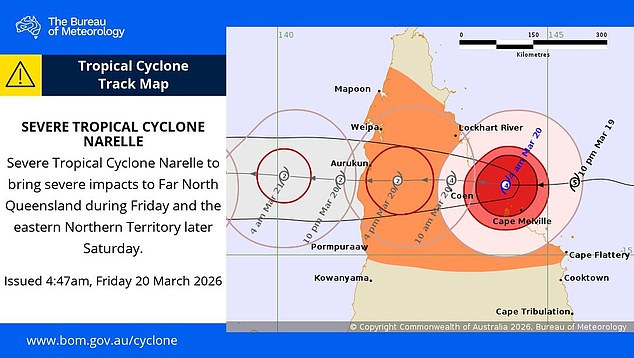
The cyclone will cross coast between Cape Melville and Lockhart River this morning as a Category 4 system after weakening slightly overnight. Very destructive wind gusts in excess of 250 km/h possible near the centre of the system as it crosses the coast
Vulnerable residents have been evacuated, tourists have returned home and schools have closed.
More than 100 emergency services personnel have been deployed as police go door-to-door to ensure locals are prepared.
After crossing Cape York, the storm is expected to lash the Northern Territory’s Top End before moving to Western Australia’s Kimberley coast.
About 500 people will be evacuated from NT’s remote Gulf of Carpentaria community of Numbulwar in the coming days.
Residents choosing to ride out the storm have been warned emergency services will not respond if conditions are too dangerous.
However, some far north Queensland residents reckon they will be fine – they have beer.
‘Everyone’s line of thought is that you can’t actually do anything during a cyclone, so let’s have a beer,’ Tim Layton, of Greenhoose family-run accommodation near the Lockhart River, told AAP.
‘Let’s make it a cyclone party because there’s going to be one hell of a clean-up.’
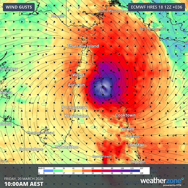
Forecast wind gusts at 10am AEST on Friday, March 20, according to the ECMWF-HRES model. Source: Weatherzone.
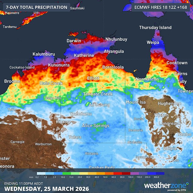
Image: Forecast accumulated rain during the next seven days. Source: Weatherzone.
His family is no stranger to storms, with flooded roads every wet season ensuring the only way in or out is by plane or barge.
‘We’re all battened down,’ Mr Layton said.
‘The generators are primed, fingers are crossed and hoping for the best – the calm before the storm, right?’
What to expect when Narelle hits Queensland
Very destructive wind gusts in excess of 250 km/h near the eye of the tropical cyclone as it makes landfall. Destructive winds with gusts of up to 160 km/h are also likely between about Lockhart River and Cape Flattery, and may extend further south to Cooktown if Narelle takes a more southerly track.Heavy rainfall leading to flash flooding is likely between Cape Melville and Cape Tribulation, initially near the coast but also extending across the Cape York Peninsula after landfall. Heavy rain could also extend south along the coast towards Port Douglas, Cairns and Innisfail on Thursday and Friday.Abnormally high tides and large waves may cause coastal inundation near and to the south of Narelle’s eye as it approaches and crosses the coast, most likely between Coen and Cape Tribulation. Tides in Princess Charlotte Bay may rise significantly above the normal high tide to cause a dangerous storm tide.
Northern Territory next in line
Narelle is likely to weaken after it makes landfall and moves across the Cape York Peninsula on Friday. It will then continue on a westerly track and pass over the Gulf of Carpentaria on Friday night into Saturday.
Computer models suggest that Narelle will re-intensify over warm water in the Gulf before making a second landfall over the Northern Territory’s eastern Top End, possibly over Groote Eylandt, later on Saturday. At this stage, Narelle could be a category 3 severe tropical cyclone when it reaches Groote Eylandt.
Narelle will weaken again after making landfall in the NT, most likely dropping below tropical cyclone strength as it moves across the Top End and Western Australia’s Kimberley district on Sunday and Monday. This could cause more heavy rain over flood-ravaged areas of the NT around Daly Waters and Katherine.