
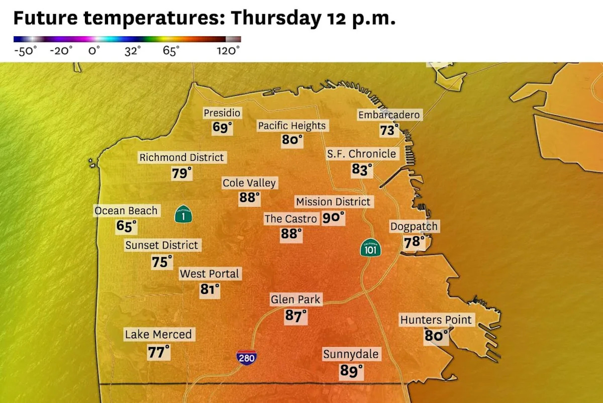
Parts of San Francisco are likely to hit 90 degrees on Thursday, in what will be the hottest day for the city since this year’s historic March heat wave that brought the city its first 90-degree March day on record.
A heat advisory begins at noon Thursday across much of the Bay Area. For the San Francisco Bay shoreline and North Bay, the advisory runs through Thursday evening. Farther inland, including parts of the East Bay and Santa Clara Valley, heat concerns may linger into Friday.
By Thursday morning, temperatures had already climbed into the mid- to upper 80s across the Mission, Potrero Hill and parts of the southeastern neighborhoods, while some of the city’s hills were recording temperatures in the low 90s.
Oakland and Berkeley have a shot at hitting 90 degrees as well. Inland valleys will run 15 to 30 degrees above normal, with the first triple-digit readings of the year likely in parts of the North Bay, East Bay and South Bay.
The hottest spots will include Concord, Walnut Creek, Antioch, Livermore, Santa Rosa and portions of southern Santa Clara County, where highs may reach the upper 90s to around 105 degrees. A handful of climate stations may flirt with or exceed daily records for June 11.
This will not be a long-duration heat wave for everyone. But it also may not end at the same time everywhere.
Along the coast in San Francisco and parts of the North Bay, temperatures should turn cooler Friday, though still above normal, as a weak sea breeze begins to return. But farther inland, especially in the East Bay and South Bay, the marine push may be too weak to bring meaningful relief right away. That means some inland communities should stay hot Friday and possibly remain well above normal into the weekend.
Despite a gust of 69 mph at 5:30 am at Mount St. Helena, early morning wind gusts did not materialize as expected and the red flag warning for the North Bay interior mountains and East Bay hills has been canceled.
Why it’s hot, and why the cooldown will be uneven
The culprit is a strong but transient ridge of high pressure centered off the Pacific Northwest coast. The Bay Area sits on the southeast side of that ridge, where dry offshore wind flow pushes the marine layer offshore and allows temperatures to rise, even near the water.

The offshore high pressure ridge (dark red) will shift north towards the Pacific Northwest and British Columbia over the weekend. S.F. and the bayshore should cool down, but interior locations will remain hot. (WxBell )
The ridge will shift north toward British Columbia by Friday, which should open the door for some onshore flow. But forecast models are not showing a strong marine surge. Instead, relief may arrive first along the coast and near San Francisco Bay, while inland valleys remain largely cut off from the cooling influence of the Pacific.
That makes Friday’s temperature forecast more varied. San Francisco and areas near the bayshore should see temperatures fall back into the 70s. But inland areas like Walnut Creek, Livermore, Antioch and San Jose will still see daytime highs in the mid-90s.
Dangerous beach conditions
The heat will likely send more people toward the coast Thursday. But the ocean will not be calm just because the weather is warm.
A long-period southerly swell will continue to bring an increased risk of sneaker waves and strong rip currents to south- and southwest-facing beaches. The highest concern includes the North Bay coast, San Mateo County coast and Santa Cruz County beaches.
A beach hazards advisory statement is set to expire at 5 a.m. Thursday for the coastal North Bay including Point Reyes, the San Francisco Peninsula coast and northern Monterey Bay, but elevated rip current and sneaker wave risk will linger throughout the day.
And long-period swells will keep the risk of sneaker waves and strong rip currents in place into the weekend.
Thursday breakdown
San Francisco: Thursday will be hot everywhere in the city. The marine layer will retreat back over the ocean and temperatures will quickly heat up. Highs will top out in the mid to upper 80s, with some low 90s, in the Mission, SoMa and Mission Bay. A light ocean breeze will be enough to keep Ocean Beach in the 70s, but the Sunset and Richmond districts should see highs in the low 80s. Overnight lows will stay warm, mostly in the upper 50s to mid-60s.
North Bay: The interior North Bay will be toasty on Thursday, with some daily records being challenged. The hills will start the day under elevated fire danger after a windy and dry night, especially in the North Bay interior mountains. Winds should ease after sunrise, but humidity will remain very low through the afternoon. Santa Rosa, Novato, Vacaville and Fairfield should all hit triple digits. Napa, San Rafael and Petaluma should see temperatures in the upper 90s. It should stay clear and warm overnight with lows ranging in the upper 50s in valleys to the 60s and low 70s in the hills.
East Bay:
The interior East Bay will have some of the hottest weather in the region on Thursday. Concord, Walnut Creek, Pleasanton, Livermore and Antioch will likely reach the low 100s, with a few spots pushing higher. Oakland, Alameda, Berkeley and Richmond will warm into the mid-80s or even to 90, with warmer pockets in the Berkeley foothills and away from the bay. Winds won’t be an issue overnight, but it will be warm again in the hills with lows in the 70s. Elsewhere, temperatures will fall back into the low 60s.
Pacific Coast and Peninsula: The marine layer should be weaker than usual on Thursday, allowing Pacifica, Daly City and Half Moon Bay to warm into the upper 70s to around 80 degrees. Across the Peninsula, South San Francisco, Burlingame and San Mateo should see highs in the mid to upper 80s. Redwood City should spike into the mid-90s. Beach hazards will be a concern along the San Mateo County coast, with sneaker waves and rip currents possible. Overnight lows will be mild, mostly in the upper 50s to 60s.
South Bay and Santa Cruz: San Jose, Mountain View, Sunnyvale and Cupertino should climb well into the 90s on Thursday, while Morgan Hill and Gilroy will likely top 100 degrees. Santa Cruz will be cooler, but still warm with highs in the mid-80s. The Santa Cruz Mountains will be warm and dry, with elevated fire concerns lingering through the morning. It will be clear and warm overnight with lows in the 60s.
Subscribe
There’s more to San Francisco with the Chronicle. Subscribe today for just 25¢.
This article originally published at San Francisco is likely to hit 90 degrees on Thursday.