
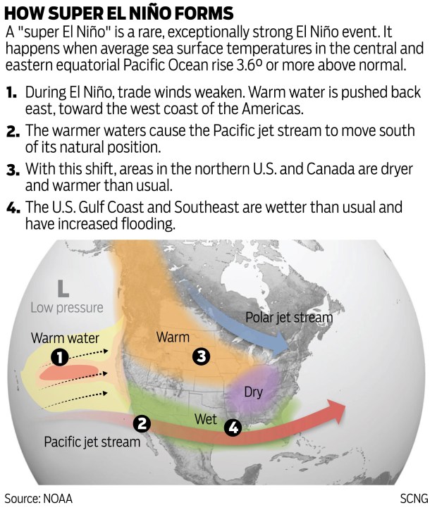
Heavy rains, damaging floods, debris flows from burn scar areas, beach erosion, high surf, even growth of fire-prone dry grasses by spring are results of a wet winter triggered by a warming ocean phenomenon known as El Niño.

These three images released on May 29, 1997, depict the evolution of a warm water Kelvin wave in the equatorial Pacific Ocean during March and April 1997. Kelvin waves are often precursors to El Nino events which can disrupt global weather patterns. These data were collected by the altimeter onboard the joint US/French TOPEX/Poseidon satellite and these images show sea surface height relative to normal ocean conditions. The white and red areas indicate unusual patterns of heat storage where the sea surface is elevated up to about 20 centimeters (about 8 inches) and 10 centimeters (4 inches) respectively. The El Nino phenomenon is thought to be triggered when the steady westward blowing trade winds weaken and even reverse direction. This change in the winds allows the large mass of warm water (the red and white area) that is normally located near Australia to move eastward along the equator until it reaches the coast of South America. The warm water mass can affect where rain clouds form and, consequently, alter the typical atmospheric jet stream patterns around the world. Using these data, the National Oceanic and Atmospheric Administration, (NOAA) has issued an advisory indicating the presence of the early indications of El Nino conditions. A number of El Nino forecast activities supported by NOAA indicate the likelihood of a moderate or strong El Nino in late 1997. The forecast model operated at NOAA’s National Centers for Environmental Prediction (NCEP) used data collected by the TOPEX/Poseidon satellite. (Courtesy, JPL/NASA)

In this Feb. 24, 1998 file photo, a woman waits for a tow truck on the hood of her brother’s pickup after a wall of mud plowed down Laguna Beach Canyon Road in Orange County, Calif. forcing her to evacuate her home, in background. A long anticipated El Nino weather warping is finally here. (AP Photo/Nick Ut, File)

In Irwindale, the Santa Fe Dam spillway was spilling at 75% capacity, opening 12 of it’s 16 gates because the system was at flood stage on Feb. 24, 1998. They were releasing water at the rate of 11,000 cubic feet per second, and it’s the first time the dam has released water since 1993. According to the operator, this rate is far higher than in recent memory. A cubic foot of water is equivalent to 7.5 gallons. (Photo by Tim Berger, Pasadena Star-News/SCNG)

A luxury home in the Orange County suburb of Laguna Niguel slips down a hillside on March 19, 1998, eroded by heavy El Nino generated rains earlier in the month. Two homes and seven condominiums have been destroyed in the slide and several more are threaten with destruction. More rains are expected early next week. (Photo by Vince Bucci/AFP via Getty Images)

Workers cover an entire house with blue plastic tarp to protect the home at the corner of Santa Anita Ave and Calaveras Street in Altadena, from water leaking through the roof. El Nino storms arrived on Dec. 5, 1997, in the southland bringing anticipated heavy rains. (Photo by Walt Mancini, Pasadena Star-News/SCNG)

Two inspectors survey the damage done to luxury condominiums in the Orange County suburb of Laguna Niguel, CA after they slipped down a hillside on March 19, 1998, eroded by heavy El-Nino generated rains earlier in the month. Two home and 7 condominiums have been destroyed in the slide and several more are threaten with destruction. (Photo by VINCE BUCCI/AFP via Getty Images)

MANHATTAN BEACH, UNITED STATES: A surfer rides a wave off Manhattan Beach on January 16, 1998, where the El Nino weather phenomenon has created larger waves. In the background is an anchored cargo ship. (Photo by Mike Nelson/AFP via Getty Images)
Show Caption
1 of 7
These three images released on May 29, 1997, depict the evolution of a warm water Kelvin wave in the equatorial Pacific Ocean during March and April 1997. Kelvin waves are often precursors to El Nino events which can disrupt global weather patterns. These data were collected by the altimeter onboard the joint US/French TOPEX/Poseidon satellite and these images show sea surface height relative to normal ocean conditions. The white and red areas indicate unusual patterns of heat storage where the sea surface is elevated up to about 20 centimeters (about 8 inches) and 10 centimeters (4 inches) respectively. The El Nino phenomenon is thought to be triggered when the steady westward blowing trade winds weaken and even reverse direction. This change in the winds allows the large mass of warm water (the red and white area) that is normally located near Australia to move eastward along the equator until it reaches the coast of South America. The warm water mass can affect where rain clouds form and, consequently, alter the typical atmospheric jet stream patterns around the world. Using these data, the National Oceanic and Atmospheric Administration, (NOAA) has issued an advisory indicating the presence of the early indications of El Nino conditions. A number of El Nino forecast activities supported by NOAA indicate the likelihood of a moderate or strong El Nino in late 1997. The forecast model operated at NOAA’s National Centers for Environmental Prediction (NCEP) used data collected by the TOPEX/Poseidon satellite. (Courtesy, JPL/NASA)
Meteorologists put the likelihood of an El Niño at 90% or more this winter, meaning the warmer jet stream is likely to direct above-average rainfall into Southern California, as a lineup of storms drop rain that play havoc with local infrastructure and everyday life.
At the invite of the Los Angeles County Board of Supervisors on Tuesday, Sept. 1, close to a dozen Los Angeles County department heads laid out their plans for preparing for an El Nino-powered, possibly record-setting, wet 2026-2027 winter.
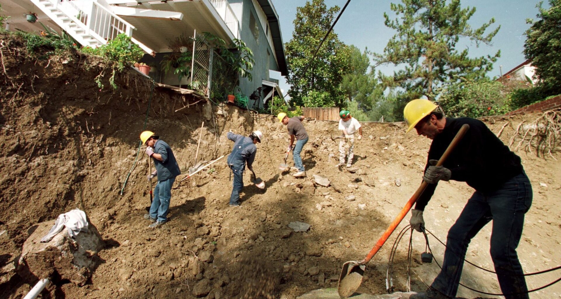
Areas denuded by wildfires are focal points for warnings and possible evacuation orders, said county officials. This includes Altadena and the Pacific Palisades-Malibu areas, both devastated by the January 2025 fires and more prone to mudflows.
“We will be prioritizing vulnerable communities where we deploy resources in relation to the risk,” said Public Works Director Mark Pestrella. “We are placing significant attention on Altadena,” he said, concerned about rains moving rocks and sediments from hills and surrounding mountain areas blackened by the Eaton fire.
Next on the watch list are low-lying areas prone to flooding, such as Pacific Coast Highway, which can experience erosion and slipping slopes, he said. Also, the north county area is where significant damage has occurred in the past due to poor drainage and dangerous roadway washouts, he added.
If a heavy storm is predicted to flood the burn areas, that could trigger evacuations. Without referencing the problems with evacuation orders during the Eaton fire in Altadena that killed 19 people and destroyed 9,400 homes and buildings, Pestrella said: “This year, Public Works will be making the calls on evacuations. I will take that responsibility.”
Public Works is also responsible for making sure all county debris basins, channels and dams are functioning. Pestrella said they will have been cleaned out and ready for holding water by October 15 — the start of the rainy season, Pestrella said.
He also said 600 county Public Works employees will be on 24/7 standby through April.
Kevin McGowan, director of the county Office of Emergency Management, spoke of personal responsibility.
“Every resident should understand their flood risk and consider purchasing flood insurance,” he said. “Residents should act now and not wait.”
If homeowners need assistance, get tips on preparation, or learn how the water drains off their property, they can call Public Works at: or visit www.ready.lacounty.gov. Pestrella urged them to clear out gutters. Also, he urges parents to keep their children far away from flood channels or creeks during a storm.
“The most tragic losses is children entering into the flood control system,” he said.
During the February 1998 storms, the largest El Niño in the 20th Century, there were 17 storm-related deaths in California from rainstorms, mudslides, floods and fallen trees. That month set precipitation records at 19 stations in California. Many were not expecting this much rain.
On Feb. 7, 1998, 20-year-old Nathan Cook was riding his mountain bike in the normally quiet Arroyo Seco in Altadena when a wall of water swept him away. In an instant, the experienced mountain biker and Occidental College student was dead. They found his body four days later pinned against a tree near Devil’s Gate Dam.
That same month, a eucalyptus tree on College Avenue in Claremont fell, crashed through a car and killed two Claremont College sophomores, Brian G. Cressner and Yuta Peter Kurahashi. The ground was soaked and unstable.
In the San Fernando Valley, Frank Metz, 84, of Los Angeles, died when his car plunged off a road that had been undermined by rains and runoff.
“It is very dangerous to drive in rain,” Pestrella said. “If you don’t have to drive in a day when it is raining hard, don’t drive. Because there are roads that are vulnerable.”
Some debated whether too much warning can lead to “warning fatigue.”
Supervisor Janice Hahn, who represents the Fourth District, took issue with TV station weather reporters blasting viewers with “Storm Watch 2027!” when what only falls is a sprinkling. She also said the cable TV Emergency Alert System that fills the screen with tiny fonts of vague information gets ignored by most.
“That kind of emergency messaging people become numb to. Most feel it is irrelevant,” Hahn said.
“We need to be more specific about what we are asking the public to do,” she said. She asked McGowan to find a way to change that alert system. She suggested the county use its cable channel to broadcast alerts prior to a storm or earthquake.
Andrew Vies, acting director of County Communications, said that could be done on the county cable channel. He also suggested putting a banner on every county website whenever an extreme rainstorm is coming.
The departments spoke of ways they would help when or if there is a severe rainstorm:
• County OEM will work on evacuation planning, particularly in burn scar areas. A list of county-owned properties also will be protected from flooding and wind damage.
• County Public Works is pre-deploying resources at areas more flood prone and clearing out debris basins and dams.
• Sheriff Robert Lunda said the Homeless Outreach Services Team (HOST) will be going to unhoused populations in riverbeds (L.A. River, Rio Hondo River, San Gabriel River) to provide warnings and help with evacuations. They also do swift water rescues.
• Homeless Services and Housing will identify emergency interim housing sites. It’s also looking to set up more, since there’s not enough. Carter Hewgley, chief strategy officer, said the department is working on getting more emergency motel vouchers.
• Beaches and Harbor’s Gary Jones said like every winter, they will set up 15-foot-tall sand berms to stop surging waves from rushing over the flat beach or into the parking lots. Also, if necessary, lifeguard towers will be moved.
• Department of Public Social Services, which serves 4 million clients, will do wellness checks and pre-identify potential shelter sites with the American Red Cross.
• Department of Aging and Disabilities will tie in personnel from 200 senior centers in the county with communication on how to be prepared for a rainstorm.
To learn about active emergencies, or to register for emergency alerts, visit: lacounty.gov/emergency.